
Nontronnais
The Nontronnais is a French landscape in the northern Dordogne department in the Nouvelle-Aquitaine region . It corresponds to the surroundings of the sub-prefectural town of Nontron , which is located in its center. Jules Verne had given the Nontronnais the name Périgord vert (Green Périgord). This term is now mainly used in the tourism industry. However, it is not congruent with the actual Nontronnais, but rather covers a much larger area.
geography

The Nontronnais occupies the extreme north of the Dordogne department. In administrative terms , it is composed of the Communauté de communes du Périgord vert nontronnais and the Communauté de communes du Haut-Périgord , which have since merged to form the Communauté de communes du Périgord Nontronnais . It therefore consists of 28 municipalities with a total of 15,567 inhabitants (as of 2014) and an area of 560.25 square kilometers. With a resulting population density of 28 inhabitants per square kilometer, the Nontronnais is very sparsely populated.
Some authors limit the nontronnais in the narrower sense only to the 17 communities of the former Communauté de communes du Périgord vert nontronnais.
The Nontronnais is surrounded by the following landscape regions:
- from the Pays de la Vienne in the Haute-Vienne department in the north
- from the Pays d'Uzerche and the Pays de Brive in the Corrèze department to the east
- from Périgord central and Ribéracois in the Dordogne department in the south
- from the Pays d'Horte et Tardoire in the Charente department in the west.
In a broader sense, the Nontronnais can be assigned to four additional partial landscapes in addition to its core area:
- the surroundings of Bussière-Badil - the Pays de Bussière-Badil
- the surroundings of Thiviers - the Pays de Thiviers
- the surroundings of Jumilhac-le-Grand - the Pays de Jumilhac
- the surroundings of Lanouaille - the Pays de Lanouaille .
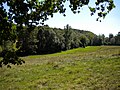
Topographically, the Nontronnais covers the northwestern foothills of the Massif Central , which is why it is sometimes referred to as the Périgord limousin . Its relief is made up of undulating plateaus, the altitude of which varies between 200 and 370 meters and slopes gently towards the southwest. The rivers of the Auvézère , Bandiat , Loue and Isle have cut into these plateaus, sometimes forming green gorges. The climate is under the influence of the Atlantic Ocean and is very humid with around 1000 millimeters of precipitation per year. This in turn requires a rather lush growth of vegetation, which is dominated by chestnuts , spruce , Scots pine , ferns , heather , gorse and reeds .
The term Périgord vert used in tourism is broader. It contains not only the actual Nontronnais still a small part of northern Périgord central as well as the Périgord blanc belonging Ribéracois - these two lands are underlain by limestones and therefore are fundamentally different in their geological structure.
geology

The geologically significant boundary between the Variscan basement of the Massif Central in the northeast and the relatively flat sediments of the Aquitaine Basin in the southwest runs through the Nontronnais . The boundary is usually marked by a major disruption . The crystalline basement consists of high-grade paragneiss of the sillimanite facies as well as granitoids such as the Piégut-Pluviers-granodiorite and the Saint-Mathieu-leuco granite . From Thiviers onwards, the rocks of the Thiviers-Payzac unit appear in the basement to the southeast . To the north of Saint-Jean-de-Côle there are mainly gneiss of the lower gneiss cover of the Limousin and rare oceanic rocks.
The sediments of the Aquitaine Basin are home to arcs , dolomites and slate clays from the Lias and various limestone from the Great Dane . The separating marginal fault runs from Saint-Pardoux-la-Rivière through the lower town of Nontron on towards Saint-Martin-le-Pin . It is mineralized and was therefore mainly mined for lead , zinc and some silver . The mining is now no longer profitable and has therefore come to a standstill.
history

Until the French Revolution , only a few communities in the north of what is now the Dordogne department belonged to the Périgord . The parishes of the archpriest of Nontron depended on the diocese of Limoges . The vast majority of these parishes, however, were then integrated into the newly created Dordogne department. These included the following municipalities: Ajat (today's Abjat-sur-Bandiat ), Augignac , Busseroles (now Busserolles ), Champniers et Reillac (from 1847 Champniers-et-Reilhac ), La Chapelle-Montmoreau , Connezac , Javerlhac, Saint-Robert ( since 1823 Javerlhac-et-la-Chapelle-Saint-Robert ), Millac (today's Milhac-de-Nontron ), Nontron , Nontronneau (now Lussas-et-Nontronneau ), Pluviers (today's Piégut-Pluviers ), Quinsac , Romain (now the Champs-Romain ), Saint-Angel (now Sceau-Saint-Angel ), Saint-Barthélemy (now Saint-Barthélemy-de-Bussière ), Saint-Etienne (now Saint-Estèphe ), Saint-Front-de -la-Rivière (now Saint-Front-la-Rivière ), Saint-Martial (now Saint-Martial-de-Valette ), Saint-Martin-le-Peint (now Saint-Martin-le-Pin ), Saint- Pardoux (now Saint-Pardoux-la-Rivière ), Saint-Saud (now Saint-Saud-Lacoussière ), Teyjac (now Teyjat ) and Varaigne (now Varaignes ).
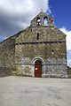
Monuments and sights

- Teyjat cave
- Peyrouse Monastery
- Notre-Dame-de-la-Nativité (Bussière-Badil)
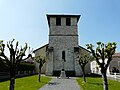
- St-Martial (Busserolles)
- St-Paul (Reilhac)
See also
Photo gallery

The Saint-André church in Abjat

Roche Eyside at Augignac

The Étang Grolhier at Busserolles

The Saint-Paul church in Reilhac

The Saint-Pierre church in La Chapelle-Montmoreau

Saint Martin in Connezac

The Saint-Robert church in La Chapelle-Saint-Robert
The Saint-Jean church in Nontronneau
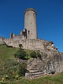
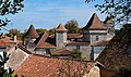
The tower of Piégut
The Saint-Saturnin church in Quinsac
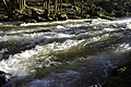
The Saut du Chalard in the Dronne near Champs-Romain

The Saint Michel church in Saint-Angel

Megalithic burial chamber in La Courarie

The Roc branlant near Saint-Estèphe
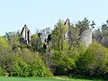
The castle ruins of Château de la Renaudie near Saint-Front-la-Rivière

The Saint-Martial church in Saint-Martial-de Valette

Church portal in Saint-Martin-le-Pin

The Saint-Pardoux church in Saint-Pardoux-la-Rivière
The Marcourive at Teyjat
The castle in Varaignes

The bandiat at Saint-Martial-de-Valette


.JPG)


.JPG)


_%C3%A9glise_(6).JPG)


.JPG)
.JPG)


literature
- Bernard Briand et al: Châlus XIX-32 . In: Carte géologique de la France at 1/50 000 . BRGM, Orléans.
- J.-P. Floc'h et al: Nontron XVIII-33 Anticlinaux du Périgord blanc . In: Carte géologique de la France at 1/50 000 . BRGM, Orléans.
- P.-L. Guillot et al.: Thiviers XIX-33 Vallée de la Côle . In: Carte géologique de la France at 1/50 000 . BRGM, Orléans.
- G. Le Pochat et al .: Montbron . In: Carte géologique de la France at 1/50 000 . BRGM, Orléans 1986.
Individual evidence
- ^ Jacques Lagrange: Nontron et le pays nontronnais . vol. 1, Pilote24, 1996, ISBN 2-9509149-1-8 , pp. 251 .
- ↑ Frederic Zégierman: Le Guide des pays de France, Sud . Fayard, 1999.
- ^ Bénédicte and Jean-Jacques Fénié: Dictionnaire des pays et provinces de France . Éditions Sud-Ouest, Bordeaux 2000, ISBN 978-2-87901-367-1 , p. 349 .
- ↑ Alexis de Gourgues: La Dordogne. Dictionnaire topographique du département. In: Chaulnes: Res Universis. Reprise de l'édition restaurée de 1873 . 1992, ISBN 2-87760-904-9 .