
Champs-Romain
|
Champs-Romain Los Champs e Romanh |
||
|---|---|---|
|
||
| region | Nouvelle-Aquitaine | |
| Department | Dordogne | |
| Arrondissement | Nontron | |
| Canton | Périgord Vert Nontronnais | |
| Community association | Périgord Nontronnais | |
| Coordinates | 45 ° 32 ' N , 0 ° 47' E | |
| height | 155-344 m | |
| surface | 20.33 km 2 | |
| Residents | 286 (January 1, 2017) | |
| Population density | 14 inhabitants / km 2 | |
| Post Code | 24470 | |
| INSEE code | 24101 | |
 Champs-Romain Town Hall |
||

Champs-Romain , Occitan Los Champs e Romanh , is a French municipality with 286 inhabitants (at January 1, 2017) of the North department Dordogne in the region Nouvelle-Aquitaine (before 2016 Aquitaine ). It belongs to the Arrondissement of Nontron and the canton of Périgord Vert Nontronnais ( Saint-Pardoux-la-Rivière until 2015 ). The responsible community association is the Communauté de communes du Périgord Nontronnais .
etymology
The North Occitan champs , derived from the Latin campus , means fields . Romanh emerged from the Gallo-Roman proper name Romanius .
geography
Champs-Romain is nine kilometers east of Nontron and five kilometers north-northeast of Saint-Pardoux-la-Rivière (as the crow flies).
The community is surrounded by the following 4 neighboring communities:
| Abjat-sur-Bandiat | Saint-Saud-Lacoussière | |
| Savignac-de-Nontron |
.svg)
|
Saint-Saud-Lacoussière |
| Saint-Pardoux-la-Rivière | Saint-Pardoux-la-Rivière |
In addition to the town center, the municipal area of Champs-Romain includes the following hamlets, farmsteads, castles, a mill and landmarks:
Bellevue , Bord , Champs-Romain , Château le Verdoyer , Croix de Mâlemorts , Fresseing , La Bruyère , La Chabaudie , La Courière , La Croix , La Forge , La Pinière , La Robertie , La Valade , Le Caillou Blanc , Le Claud Durand , Le Codert , Le Communal de Bord , Le Grand Bols , Le Jolivet , Le Petit Bois , Le Piélut , Le Terme , Le Terme de la Motte , Le Verdoyer , Le Verthamont , Les Bessines , Les Bruneries , Les Charbonnières , Les Grands Clauds , Les Gravoux , Les Juilleries , Les Pinquelies , Les Placiaux , Marmeix , Moulin de la Valade , Paugnac , Pierres Blanches , Plaisance , Puyhardy , Romain , Saut du Chalard and Verlaine .
The topographically lowest point of the municipality is 155 meters above sea level on the Dronne in the extreme south, the highest point at 344 meters north of Verlaine in the northeast. The town center is at 302 meters. The maximum difference in altitude is 189 meters.
Transport links

The town center is crossed by the D 83, which branches off after Saint-Saud-Lacoussière near Les Bessines from the D 79 leading to Nontron in a south-westerly direction to Saint-Pardoux-la-Rivière. The D 85 runs from Châlus ( Haute-Vienne ) to Nontron along the north-western border of the municipality . Coming from the east, the D 79 joins the D 85 from Saint-Saud-Lacoussière and the D 96 from Les Gravoux from the southeast, a cross-connection that branches off the D 79 to Abjat-sur-Bandiat and on to Piégut-Pluviers .
Hydrography
The southeast border of the municipal area of Champs-Romain is formed by the Dronne , meandering in a narrow gorge to the southwest , which has cut 100 meters deep into the basement. Its right tributary, the Ruisseau de Lachenaud , defines the southwest border to Saint-Pardoux-la-Rivière. The Le Manet , coming from the northeast, flows into it and drains the municipal area roughly centrally. A right branch of the Le Manet is the Ruisseau de la Grand Mère . The Ruisseau la Malencourie , also a right branch of the Dronne, which flows in a north-south direction , marks the eastern border with Saint-Saud-Lacoussière. The municipality belongs to the catchment area of the Dronne.
geology

The municipal area of Champs-Romain lies entirely on the metamorphic , Variscan basement of the northwestern Massif Central . In particular, it belongs to the Saint Mathieu Cathedral . The western part is built up by neoproterozoic paragneiss ( ζ 1 and ζ 1-2 ), which are replaced in the eastern part by structurally deeper mica schists ( ξ 1 ) of the parautochthonous mica slate unit . It is very likely that this is a major abnormal contact ( ceiling thrust ).
However, the original contact is completely covered by the intrusive Saint-Mathieu leukogranite ( γ 2M ), which also underlies most of the eastern municipality as Saint-Saud leukogranite . The mica schist are therefore only as small islands (in Les Pinquelies and Paugnac ) in leucogranite survived. In the lower reaches of the Le Manet are Ordovician Leptynite ( f λ b 3-4 ) incorporated in the paragneisses. The paragneiss are highly metamorphic and sometimes have the degree of Anatexis managed to recognize smaller Granodioritkörpern ( γ b 3-4 ) west of Les Juilleries (already in the municipality of Saint-Pardoux-la-Rivière) associated with the from the Westphal originating from Piégut-Pluviers-Granodiorit ; the actual granodiorite ( γ 3M ) is barely touched near Les Gravoux in the north-west, but here it is deeply weathered to form alterites.
The leuco granite in turn penetrated towards the end of the Upper Carboniferous along the north-south oriented contact zone; During its cooling phase, it was interspersed with microgranitic ( μ γ 3 ) and lamprophyric ( ν ) swarms of veins . The microgranite flock strikes north-north-west-south-south-east, the lamprophyres are more or less north-south oriented. Some quartz ( Q ) and pegmatite ( P ) veins are also present, also striking north-south. A larger, north-northeast-oriented pegmatite deposit is found east of Croix de Mâlemorts . A graphite train ( gra ) in the paragneiss that begins at Moulin de la Valade strikes north-west.
The basement is traversed by numerous faults , all of which show typical Variscan stripes - north, north-northeast and east.
The leuco granite is enriched in uranium in places near the north-south trending lamprophyre veins (near Les Gravoux ) and contains, for example, the minerals autunite and chalcolite near La Robertie . However, the deposits were classified as not worthwhile. Tourmaline ( Schörl ) can be found in the paragneiss.
The ridges along the D 85 and near Marmeix are covered by colluvium (Formation Ac ), probably from the Würm Age - mainly sands enriched with quartz pebbles. The alluvial sediments of the drone (formation K ) also originate from the Würm period . They are up to 2 meters thick and contain basement rocks made of quartz, granite and leptynite as well as river sands in their hanging walls.
ecology
Champs-Romain is an integral part of the Périgord-Limousin Regional Natural Park .
history
Until 1875 the community was only called Romain , derived from the district of the same name. The double name valid today was then chosen.
Population development
| Population development in Champs-Romain | ||||
|---|---|---|---|---|
| year | Residents |

|
||
| 1962 | 433 | |||
| 1968 | 410 | |||
| 1975 | 373 | |||
| 1982 | 332 | |||
| 1990 | 331 | |||
| 1999 | 328 | |||
| 2006 | 318 | |||
| 2007 | 317 | |||
| 2008 | 313 | |||
| 2012 | 308 | |||
| 2015 | 301 | |||
| 2017 | 286 | |||
Source: INSEE
The population development in Champs-Romain has generally declined since 1962 (population loss of 34 percent), but the trend has flattened since 1982.
With an area of 20.33 square kilometers, the municipality of Champs-Romain has a population density of 14 inhabitants / km².
mayor

The mayor of Champs-Romain has been Guy Lastère, an independent postal worker since March 2008.
economy
employment
In 2012, the working age population aged between 15 and 64 was 119, which is 38.6% of the total population. The number of unemployed has decreased from 7 to 6 in 2007, the unemployment rate is thus 5.0% of the working age population.
Companies
As of December 31, 2013, 35 companies were located in the municipality, 12 of them in the trade, transport or services sector, 9 in agriculture, forestry or fishing, 8 in construction, 3 in industry and 3 in the administration, teaching, health or social sectors .
Attractions
- Saint Avit Church
- Saut du Chalard , rapids in the Dronne below Romain .
- Château le Verdoyer with campsite.
Photo gallery
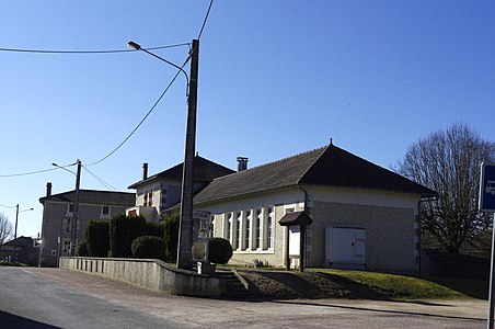 Town center with town hall and ballroom
 Old weighing house next to the church
 Old wayside cross in Champs-Romain
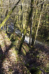 The Dronne on the Saut du Chalard


literature
- B. Briand et al .: Feuille Châlus . In: Carte géologique de la France à 1/50000 . BRGM.
- P.-L. Guillot and others: Feuille Thiviers . In: Carte géologique de la France à 1/50000 . BRGM.
Individual evidence
- ↑ Champs-Romain on the Insee website
- ↑ Abbé Charles: Dictionnaire des paroisses du Périgord (new edition) . Editions du Roc de Bourzac, Bayac 2004, ISBN 2-87624-125-0 , p. 241 .