
Mialet (Dordogne)
| Mialet | ||
|---|---|---|

|
|
|
| region | Nouvelle-Aquitaine | |
| Department | Dordogne | |
| Arrondissement | Nontron | |
| Canton | Thiviers | |
| Community association | Périgord-Limousin | |
| Coordinates | 45 ° 33 ' N , 0 ° 54' E | |
| height | 250-391 m | |
| surface | 37.30 km 2 | |
| Residents | 613 (January 1, 2017) | |
| Population density | 16 inhabitants / km 2 | |
| Post Code | 24450 | |
| INSEE code | 24269 | |
_%C3%A9glise.JPG) The Notre-Dame du Scapulaire church |
||

Mialet , often also Miallet , Occitan Mialet , is a French commune with 613 inhabitants (as of January 1, 2017) in the north of the Dordogne department in the Aquitaine region . It belongs to the Arrondissement of Nontron and the Canton of Thiviers . The community association responsible is the Communauté de communes Périgord-Limousin . The inhabitants are called Mialletais or Mialletaises .
etymology
Mialet is derived from the Neo-Latin melusetum , which means apple orchard or apple orchard . Melusetum, for its part, goes back to the Latin malus (apple).
geography
Mialet is 13 kilometers southwest of Châlus and 15 kilometers north of Thiviers (as the crow flies). It's just under six kilometers to La Coquille in the east .
The community is surrounded by the following eight neighboring communities:
| Pensol (Haute-Vienne department), La Chapelle-Montbrandeix (Haute-Vienne department) | Dournazac (Haute-Vienne department) | Firbeix |
| Saint-Saud-Lacoussière |
.svg)
|
La Coquille |
| Saint-Jory-de-Chalais | Chalais |
Mialet is a border municipality to the Haute-Vienne department in the north. In addition to the town center, the municipality includes numerous hamlets, farmsteads, castles, a mill and landmarks:
Bois de Grafeuille , Bois de la Gratte , Bois de Massavit , Bois de Vieilles Forges , Boissonnie , Château la Congerie , Château de Lambertie , Chatelavy , Chez le Chevalier , Durmareix , Étang Chevrière , Étang de Chatelavy , Étang de Fougeras , Étang de Pugeras , Étang de Vivale , Feyte , Fougeras , Garrelie , Gatelinie , Grafeuille , Jambe de Banc , La Brousse , La Congerie , La Filature , La Gratte , La Maison Rouge , La Nolphie , La Valette , Lacaud , Lacouchie , Lassudrie , Le Bois des Roses , Le Clocheton , Le Dognon , Le Grand Clos , Le Maine , Le Maine du Bost , Le Montetchabroulet , Le Montibus , Le Moulin du Blé , Le Moulin de Puyraud , Le Petit Claud , Le Petit Trois Cerisiers , Le Pintou , Le Salignier , Le Soleil , Le Trou du Papetier , Lépinotte , Les Parcs , Les Places , Les Rivaux , Les Terres de Saint-Roch , Les Thermes , Les Trois Cerisiers , Lesudrie , Lordebert , Magnesse , Magoubert , Mamont , Massavit , Mazoubert , Mialet , Montéricout , Petit Mamont , Pierrebrun e , Plan d'Eau de Mialet , Pommerède , Puyraud , Puyregonde and Veyssièras .
The topographically lowest point of the municipality with 250 meters above sea level is near Boissonnie on the Côle in the south; the highest point at 391 meters is on the northwest corner at Le Petit Trois Cerisiers . The maximum difference in altitude is 141 meters. The center of the village is 324 meters above sea level.
Transport links

The town center crosses in an east-west direction on the D 79 from La Coquille to Saint-Saud-Lacoussière. The D 6a from Dournazac to Nontron runs along the north-western border of the municipality. From here, at Les Trois Cerisiers, the D 77 branches off to the south in the direction of the town center, which then continues to Saint-Jory-de-Chalais. The D 82 comes from Firbeix in the northeast. The main artery, Route nationale 21 from Limoges to Périgueux , passes Mialet 4 kilometers further east.
The closest train station to Mialet is La Coquille on the Limoges-Bénédictins-Périgueux line .
Hydrography
The meandering Dronne flows from the east through the northwest part of the municipality of Mialet and forms the western border to Saint-Saut-Lacoussière before leaving the municipality to the southwest. The south- eastern part is crossed by the Côle , which is dammed up a little east of the town center to form a 77 hectare reservoir ( Retenue de Miallet ). Shortly below Mialet, the Côle takes up the Coly as a right tributary , which, coming from the northeast, runs through the municipality approximately in the middle. It flows past in the west of the town center and is in turn held back in a smaller reservoir, the Étang de Vivale . A little further to the west (in the immediate vicinity of the western border) rises the Queue d'Ane, which drains to the south .
geology

The municipality of Mialet is located on the metamorphic basement of the northwestern Massif Central . Structurally deepest units are mica slates of the parautochthonous mica slate unit , which stand along the Dronne in the west. Its foliation generally strikes north-northwest (but can scatter from north to west-northwest) and dips in an easterly direction at 35 to 50 °. Linear show with a relatively shallow dip mainly to east-southeast to east.
The largest part of the municipal area, however, lies on structurally higher lying gneiss of the lower gneiss cover of the Limousin , which also strike north-north-west and plunge 40 ° to east-north-east. The eye gneisses can appear very massive in their middle section, it is likely to be metagranites . Towards the hanging wall (in the eastern section of the municipality) they are increasingly taking on a leptynite character (former rhyodacites and rhyolites ). Occasionally, mica slate trains (between Le Montibus and Puyraud ) and islands (near La Gratte , Montéricout and east of Montetchabroulet ) can also be embedded in the Augengneise. The contact relationships between mica schist and eye gneisses are not evident, but are likely to be of an abnormal nature (thrust), which can be recognized by the increasing degree of metamorphosis to the east.
A significant northeast-southwest trending fault zone ( La Coquille fault ) crosses south of the town center, causing the foliation to bend in the same direction.
Extensive altitudes are often veiled by Pleistocene alterites of the basement or colluvium , for example south of Veyssièras and at Les Parcs . Alluvium from the Würm Glaciation and the Holocene is located in the southern Côle Valley .
The mineralization in the Augengneisen, which is related to the Saint-Mathieu leukogranite further to the west , includes: tin ( cassiterite ) at Le Montibus and tungsten ( scheelite ) at Le Moulin de Blé .
ecology
.JPG)

The municipality of Mialet has been an integral part of the Périgord-Limousin Regional Natural Park since 1998 .
The 8 kilometers of the Dronne Valley in the municipality of Mialet are under Natura 2000 protection. The river with its bank area and the adjoining wet meadows, heather areas, fields and forests is home to a very rich fauna . This section of the Dronne is one of the most important locations in France for the offspring of freshwater pearl mussels ( Margaritafera margaritafera ). Taxa threatened with extinction such as the yellow-bellied toad ( Bombina variegata ) and the helmets' damsel ( Coenagrion mercuriale ) can also be found here in Europe. , the Marsh Fritillary ( Euphydras Aurinia ), the clawed crayfish ( Austropotamobius pallipes ), the bullhead ( Cottus gobio ) and lamprey ( Lampetra planeri ), several Säugetiertaxa such. B. the otter ( Lutra lutra ) and three bat species .
The municipality also hosts a first-order protection zone ( French ZNIEFF = zone naturel d'interêt faunistique et floristique ), which includes the following ecotopes in the municipality :
- the ravine-like Dronne valley mentioned above. Depending on the orientation of the slopes, it alternates between Atlantic and Mediterranean flora. It contains numerous fern taxa.
- the valleys of the Côle and the Coly are also protected, the valley of the Coly almost in its entire length; in the latter, for example, the slim cotton grass ( Eriophorum gracile ) is at home.
- The 25 hectare marshland and moorland along the ponds around La Maison Rouge in the north of the municipality contain rare botanical taxa.
The 77 hectare reservoir of Mialet has been classified as a sensitive natural area (French: espace naturel sensible ), as there are numerous water birds on its banks; the east bank is protected in particular as a nesting and breeding area.
history
Mialet was settled at the latest in the megalithic period - recognizable by a dolmen ( Dolmen de Vaure ). The Romanesque local church Notre-Dame du Scapulaire dates from the 12th century , but was later heavily modified. The Château de Lambertie was built around the same time . From the 16th century, two manors ( Manoir de Mialet and Manoir de Feyte ) and a castle ( Château de la Congerie ) were built in the municipality .
Population development
| Population development in Mialet | ||||
|---|---|---|---|---|
| year | Residents |

|
||
| 1962 | 1287 | |||
| 1968 | 1094 | |||
| 1975 | 1006 | |||
| 1982 | 888 | |||
| 1990 | 795 | |||
| 1999 | 717 | |||
| 2005 | 692 | |||
| 2006 | 684 | |||
| 2008 | 669 | |||
| 2010 | 662 | |||
| 2015 | 626 | |||
| 2016 | 619 | |||
| 2017 | 613 | |||
Source: INSEE
The population in Mialet has been steadily declining since 1962 (population loss of 52 percent).
With an area of 37.3 square kilometers, the population density is 16 inhabitants / km².
mayor
The Divers gauche pensioner Dominique Marceteau has been mayor of Mialet since March 2014 .
Attractions
- The Romanesque local church of Notre-Dame du Scapulaire .
- The privately owned Château de Lambertie; it was destroyed by the English in the Hundred Years War and later rebuilt. Its origins go back to the 12th century.
- The 16th century Manoir de Mialet (private property).
- The Manoir de Feyte manor from the 17th century (private property).
- The 18th century Château de la Congerie (private property).
- The Retenue de Miallet reservoir on the Côle.
Photo gallery
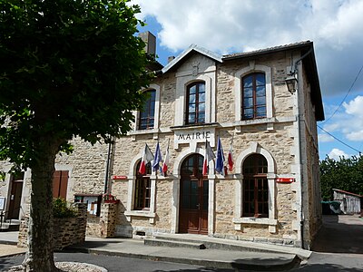 Mialet Town Hall
 Street view
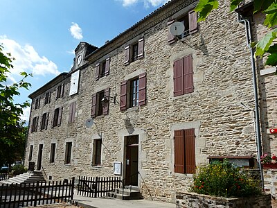 school-building
 House next to the church
 The Côle north of the D 79
 Capitals on the entrance portal of Notre-Dame du Scapulaire
 Rose window in Notre-Dame du Scapulaire
_mairie_(1).JPG)

_%C3%A9cole_(1).JPG)
_b%C3%A2timent_(1).JPG)

_%C3%A9glise_portail_chapiteaux.JPG)
_%C3%A9glise_rosace.JPG)
Individual evidence
- ↑ Drainage network of the upper reaches of the Dronne in accordance with Natura 2000 . Retrieved April 1, 2018.
- ↑ RESEAU HYDROGRAPHIQUE DE LA COLE EN AMONT DE SAINT JEAN DE COLE . Retrieved April 1, 2018.
- ↑ The Mialet Reservoir on the website of the General Council (Conseil général) . Retrieved April 29, 2010.
- ^ Mialet on the Insee website
literature
- Briand, B. et al .: Feuille Châlus . In: Carte géologique de la France à 1/50000 . BRGM.
- Guillot, P.-L. et al .: Feuille Thiviers . In: Carte géologique de la France à 1/50000 . BRGM.
- Dominique Richard (Ed.): Le Guide Dordogne-Périgord . Fanlac, Périgueux 1993, ISBN 2-86577-162-8 .