Dournazac
| Dournazac | ||
|---|---|---|

|
|
|
| region | Nouvelle-Aquitaine | |
| Department | Haute-Vienne | |
| Arrondissement | Rochechouart | |
| Canton | Rochechouart | |
| Community association | Pays de Nexon-Monts de Châlus | |
| Coordinates | 45 ° 38 ′ N , 0 ° 55 ′ E | |
| height | 288-498 m | |
| surface | 35.97 km 2 | |
| Residents | 657 (January 1, 2017) | |
| Population density | 18 inhabitants / km 2 | |
| Post Code | 87230 | |
| INSEE code | 87060 | |
 Dournazac during the chestnut festival in August |
||
Dournazac , in Occitan Dornasac , is a municipality with 657 inhabitants (as of January 1, 2017) in the Périgord-Limousin Regional Nature Park in France . It belongs to the Nouvelle-Aquitaine region , the Haute-Vienne department and the Rochechouart arrondissement . It borders in the north-west on Cussac (point of contact), in the north on Champagnac-la-Rivière , in the north-east on Châlus , in the east on Bussière-Galant , in the south on Firbeix , in the south-west on Mialet and in the west on La Chapelle-Montbrandeix . Dournazac was the highest point in the canton of Saint-Mathieu . The municipality came to the canton of Rochechouart in 2015 . The residents call themselves Dournazacois or Dournazacoises.
geology
To the east of Dournazac, in the locality of La Rougerie , there are Merlis serpentinites .
Population development
| year | 1962 | 1968 | 1975 | 1982 | 1990 | 1999 | 2008 | 2013 |
|---|---|---|---|---|---|---|---|---|
| Residents | 1,257 | 1,138 | 1.006 | 851 | 810 | 728 | 686 | 650 |
Attractions
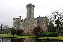
- Montbrun Castle, a monument historique
- Saint-Sulpice Church, Monument historique
- 12th Century Abbey ( L'Abbaye de Thavaud )


