
Maisonnais-sur-Tardoire
| Maisonnais-sur-Tardoire | ||
|---|---|---|
.svg)
|
|
|
| region | Nouvelle-Aquitaine | |
| Department | Haute-Vienne | |
| Arrondissement | Rochechouart | |
| Canton | Rochechouart | |
| Community association | Ouest Limousin | |
| Coordinates | 45 ° 43 ' N , 0 ° 41' E | |
| height | 165-306 m | |
| surface | 31.89 km 2 | |
| Residents | 390 (January 1, 2017) | |
| Population density | 12 inhabitants / km 2 | |
| Post Code | 87440 | |
| INSEE code | 87091 | |
 Mairie |
||

Maisonnais-sur-Tardoire , Occitan Maisonès , is a commune in southwest France with 390 inhabitants (as of January 1, 2017). It belongs to the Nouvelle-Aquitaine region (before 2016 Aquitaine ), the Haute-Vienne department , the Rochechouart arrondissement and the Rochechouart canton . The responsible community association is the Communauté de communes Ouest Limousin .
geography
Maisonnais-sur-Tardoire is the westernmost municipality of the Haute-Vienne department and borders the Charente department in the west and the Dordogne department in the south. It is 6 kilometers to Saint-Mathieu in the east, and Montbron in the Charente in the west-southwest is 24 kilometers away.
Maisonnais-sur-Tardoire is surrounded by the following seven neighboring municipalities:
| Sauvagnac (Charente department) | Les Salles-Lavauguyon | Chéronnac |
| Roussines (Charente department) |
.svg)
|
Saint-Mathieu |
| Busserolles (Dordogne department) | Champniers-et-Reilhac (Dordogne department) |
The following hamlets, farmsteads, castles, mills and landmarks belong to the municipality: Bellevue, Chadalais, Chapelas, Château de Lavauguyon (ruins), Château Rocher, Chez Faquet, Chez Réveilloux, Forêt du Gouénaix, Forêt de Lavauguyon, Galonieix, L'Age, L'Allée, La Besse, La Beysse, La Boguerie, La Borderie, La Côte, La Font Trouvée, La Grange, La Grave, La Guérite, La Ménardie, La Rousserie, Labraud, Lavauguyon, Le Clos de Ribières, Le Gouénaix, Le Graffeuil, Le Masveyraud Grand, Le Moulin de l'Age, Le Moulin de Fontfroide, Le Moulin de Maisonnais, Le Moulin de Raux, Le Poirier, Le Puy, Lécanie, Les Chenades, Les Cirejoux, Les Couteaudoux, Les Coutures, Les Dognons, Les Grands Champs, Les Landes (twice), Les Maisonnettes, Les Pécoux, Les Reitallas, Maisonnais, Mauron, Moulin de Chadalais, Sableronne, Talonat, Tramer, Vaux, Vérinelles, Vieux Château and Villa Marie .

In Maisonnais-sur-Tardoire, the lowest point is 165 meters at Le Pont Rouchaud on the Tardoire in the far west. The topographically highest point at 306 meters is at Les Dognons in the east. The absolute height difference is 141 meters.
The settlement area is on average 275 meters above sea level, the center between 280 and 265 meters. It represents a plateau-like ridge that only gradually loses height from east to west.
Transport links
The former Route nationale 699 from Saint-Mathieu to Écuras and on to Montbron crosses the village in an east-west direction . From here the D 33 branches off to Les Salles-Lavauguyon on the eastern border before Les Dognons . Another junction west of the town center towards the south enables a connection to the D 90 from Champniers-et-Reilhac to Busserolles via the D 90 E5.
The town center is connected to Champniers-et-Reilhac in the southeast via the D 33a (or D 110 in the Dordogne). To the north, the same D 33a connects with Les Salles-Lavauguyon. The D 8 B1 leaves the town center in a north-westerly direction and connects it with Sauvagnac. The D 88 runs along the western border from Busserolles to Roussines.
Hydrography

The Tardoire touches the municipality mark in the north and partially forms its border to the neighboring municipalities of Les Salles-Lavauguyon and Roussines. Nauzon and Trieux define the southern border with the communes of Champniers-et-Reilhac and Busserolles. Both river systems drain to the west in a meandering manner and have cut a good 50 meters into the plateau area of the crystalline basement . Several smaller tributaries (with the exception of the Rio de la Forêt, all nameless) drain from the plateau both north and south. The north-west corner is traversed by the Le Suchés coming from the municipality of Sauvagnac in the north-north-east - a right tributary of the Tardoire, which forms the border with Roussines before its mouth.
geology


The municipality of Maisonnais-sur-Tardoire lies entirely on the Variscan basement of the north-western Massif Central . Structurally it belongs to the Saint-Mathieu-Dom .
The eastern part is underlain by the Saint-Mathieu-Leukogranit . The northern apophysis of the Piégut-Pluviers granodiorite appears in the western part ( μ γ 3M or μ γ 3-4 ), which is enveloped by paragneiss ( ζ 1-2 ) and migmatic paragneiss ( metatexite - Mζ 1-2 ). The paragneiss in the south of the apophysis strikes east-west and falls quite steeply to the north at 80 degrees. It then changes to metatexite to the north, the strike direction of which rotates to the northeast and its angle of incidence flattens out (to 45 to 15 ° to the northwest). The metatexite may have shed in the apophysis, for example north of La Boguerie . At Talonat , a northeast-striking graphite slate ( gra ) is integrated into the metatexite .
In the northern section near Mauron , the apophysis contains trains of coplanar Roussines leukogranite ( γζ 1-2 ), which strike east-west, dip at 40 to 60 degrees to the north and almost divide the apophysis in two. This leuco granite is heavily tectonized and shows a SC structure .
The leucogranite occurs at the center in its coarse-grained normal facies ( γ 2M ), but merges to the west into the fine-grained facies of the Champniers-Reilhac leukogranite ( γ 2 ). Both facies carry a north-northwest trending gang of microgranites ( μ γ ). North of Les Dognons , a northeast trending quartz vein ( Q ) pervades the normal facies.
Furthermore, the Saint-Mathieu leukogranite has hectometric inclusions of mica schists ( ξ 1 ) from the parautochthonous mica schist unit , for example at Les Dognons , Labraud and La Ménardie . Lentils from mica slate also occur in the contact area of the two leuco granites and in the Chéronnac leuco granite. Your foliation strikes northeast here and dips at around 45 degrees to the northwest.
To the north of La Ménardie , along the Tardoire, the Chéronnac leuco granite ( O γ 1 ) is already encountered, which is foiled in an east-west direction.
To the west of the town center, the ridge between Les Landes and Sableronne is masked by the Pleistocene colluvium . This is quartz pebbles in a sandy-clay matrix (formation HC ). The river plains of Tardoire, Trieux and Nauzon (lowest section) are filled with Holocene alluvium - mainly fine sands with small quartz pebbles (formation Fy-z ).
The basement is traversed by faults that either run parallel to the microgranite dikes or strike north-northeast.
ecology

Natural park
The municipality of Maisonnais-sur-Tardoire forms an integral part of the Périgord-Limousin Regional Natural Park .
Wind turbines
In May 2015, the municipality received approval to erect three wind turbines of the 3 megawatt class. They are located on the ridge west of the town center, near Chez Faquet on the D 699. The third installation at Les Landes has since been dropped due to protests. In November 2019, the concrete foundations of the two remaining systems E 1 and E 2 were poured. The masts have now been erected and commissioning is scheduled for 2020.
history
The oldest building in the municipality of Maisonnais-sur-Tardoire is the Lavauguyon castle , which is documented for the 13th century, but is probably older. The local church of Saint-Cyprien is Romanesque architectural style . The Château Rocher is a renaissance castle .
Population development
| Population development in Maisonnais-sur-Tardoire | ||||
|---|---|---|---|---|
| year | Residents |

|
||
| 1962 | 912 | |||
| 1968 | 799 | |||
| 1975 | 696 | |||
| 1982 | 607 | |||
| 1990 | 512 | |||
| 1999 | 454 | |||
| 2004 | 477 | |||
| 2008 | 450 | |||
| 2009 | 444 | |||
| 2013 | 414 | |||
| 2014 | 400 | |||
| 2017 | 390 | |||
Source: INSEE
The population of Maisonnais-sur-Tardoire is declining sharply (total loss of 57 percent), but it recovered somewhat for a short period between 1999 and 2004.
With an area of 31.89 square kilometers, the municipality has a population density of 12 inhabitants / km² - together with the municipalities of Pensol and Les Salles-Lavauguyon, the lowest in the canton of Rochechouart.
mayor
Mayor of Maisonnais-sur-Tardoire has been Raoul Rechignac since 2010.
Attractions
- Lavauguyon castle ruins
- Saint-Cyprien Church
- Château Rocher castle
- Dovecote over entrance portal
- Upright gisant at the cemetery entrance
Photo gallery
 Lavauguyon castle ruins
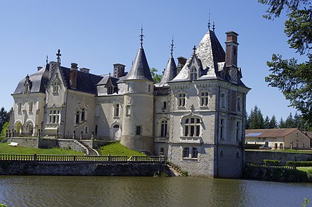 Rocher Castle
 Saint-Cyprien Church
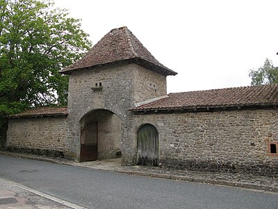 Dovecote over entrance portal
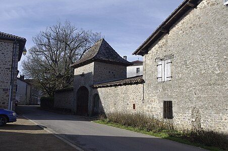 Place at the church
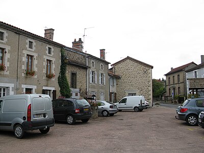 Town center
 Concrete foundation of the wind turbine E 1


Web links
- Maisonnais-sur-Tardoire on the annuaire-mairie.fr website
- Maisonnais-sur-Tardoire on cartesfrance.fr in French
- Population development since 1793 on cassini.ehess.fr