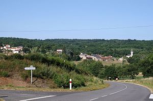
Gorre
| Gorre | ||
|---|---|---|

|
|
|
| region | Nouvelle-Aquitaine | |
| Department | Haute-Vienne | |
| Arrondissement | Rochechouart | |
| Canton | Rochechouart | |
| Community association | Ouest Limousin | |
| Coordinates | 45 ° 44 ′ N , 0 ° 50 ′ E | |
| height | 255-382 m | |
| surface | 16.17 km 2 | |
| Residents | 401 (January 1, 2017) | |
| Population density | 25 inhabitants / km 2 | |
| Post Code | 87310 | |
| INSEE code | 87073 | |
 Gorre |
||
Gorre , Gòra in Occitan , is a municipality in the Périgord-Limousin Regional Nature Park in France . It belongs to the Nouvelle-Aquitaine region , the Haute-Vienne department , the Rochechouart arrondissement and the Rochechouart canton . The residents call themselves Gorrois .
geography
The place is on the river of the same name Gorre . The municipality is bordered by Saint-Laurent-sur-Gorre to the northwest , Séreilhac to the northeast, Pageas to the southeast and Champsac to the southwest .
Population development
| year | 1962 | 1968 | 1975 | 1982 | 1990 | 1999 | 2008 | 2013 |
|---|---|---|---|---|---|---|---|---|
| Residents | 468 | 412 | 372 | 360 | 350 | 376 | 391 | 393 |
Attractions
- Exaltation of the Cross Church ( Église de l'Exaltation-de-la-Sainte-Croix )
- Gorre Castle
Web links
Commons : Gorre - collection of images, videos and audio files

