Séreilhac
| Séreilhac | ||
|---|---|---|
|
|
||
| region | Nouvelle-Aquitaine | |
| Department | Haute-Vienne | |
| Arrondissement | Limoges | |
| Canton | Aixe-sur-Vienne | |
| Community association | Val de Vienne | |
| Coordinates | 45 ° 46 ′ N , 1 ° 5 ′ E | |
| height | 218-420 m | |
| surface | 38.63 km 2 | |
| Residents | 1,992 (January 1, 2017) | |
| Population density | 52 inhabitants / km 2 | |
| Post Code | 87620 | |
| INSEE code | 87191 | |
| Website | http://www.sereilhac.com/ | |
Séreilhac ( Occitan : Cerelhac ) is a French village with 1,992 inhabitants (as of January 1 2017) in the department of Haute-Vienne in the region Nouvelle-Aquitaine . Séreilhac belongs to the arrondissement of Limoges and is part of the canton of Aixe-sur-Vienne . The inhabitants are called Séreilhacois .
geography
Séreilhac is about 18 kilometers west-southwest of Limoges . Séreilhac is surrounded by the neighboring municipalities of Saint-Priest-sous-Aixe in the north, Aixe-sur-Vienne in the east and northeast, Saint-Martin-le-Vieux in the east and southeast, Flavignac in the south, Pageas in the southwest, Gorre in the west and South-west, Saint-Laurent-sur-Gorre in the west and Cognac-la-Forêt in the north-west.
The National Route 21 and Via Lemovicensis , one of the four historical " Routes of the St. James pilgrims in France ", run through the municipality .
Population development
| year | 1936 | 1954 | 1962 | 1968 | 1975 | 1982 | 1990 | 1999 | 2006 | 2012 |
| Residents | 1,684 | 1,475 | 1,439 | 1,362 | 1,352 | 1,462 | 1,614 | 1,595 | 1,644 | 1,861 |
| Source: Cassini and INSEE | ||||||||||
Attractions
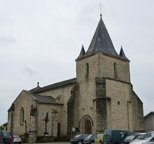
- Sainte-Marie-Madeleine church

