
Le Chalard
| Le Chalard | ||
|---|---|---|
.svg)
|
|
|
| region | Nouvelle-Aquitaine | |
| Department | Haute-Vienne | |
| Arrondissement | Limoges | |
| Canton | Saint-Yrieix-la-Perche | |
| Community association | Pays de Saint-Yrieix | |
| Coordinates | 45 ° 33 ' N , 1 ° 8' E | |
| height | 237-369 m | |
| surface | 12.42 km 2 | |
| Residents | 312 (January 1, 2017) | |
| Population density | 25 inhabitants / km 2 | |
| Post Code | 87500 | |
| INSEE code | 87031 | |
 Mairie Le Chalard |
||

Le Chalard is a French commune in the region Nouvelle-Aquitaine , in Haute-Vienne , in district Limoges and in the canton of Saint-Yrieix-la-Perche .
Le Chalard is the lowest point in the canton of Saint-Yrieix-la-Perche. The neighboring municipalities are Ladignac-le-Long in the north, Saint-Yrieix-la-Perche in the south-east and Jumilhac-le-Grand in the south-west.
Population development
| year | 1962 | 1968 | 1975 | 1982 | 1990 | 1999 | 2008 | 2013 |
|---|---|---|---|---|---|---|---|---|
| Residents | 353 | 320 | 283 | 225 | 234 | 246 | 296 | 314 |
Attractions
- Graves from the Middle Ages
- Sainte-Vierge Church, Monument historique
- Remains of a fortress
- Maison des Anglais, Monument historique
- Pont de la Tour, a road bridge and a monument historique
- Former priory, monument historique

Graves from the Middle Ages

Sainte-Vierge church

Remains of a fortress

Maison des Anglais

The bridge "Pont de la Tour" on the Isle that here the border with le-Grand Jumilhac- forms

Former priory
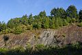
Rock formation at Le Chalard


.JPG)


Web links
Commons : Le Chalard - collection of images, videos and audio files