
Nedde
| Nedde | ||
|---|---|---|
|
||
| region | Nouvelle-Aquitaine | |
| Department | Haute-Vienne | |
| Arrondissement | Limoges | |
| Canton | Eymoutiers | |
| Community association | Portes de Vassivière | |
| Coordinates | 45 ° 43 ′ N , 1 ° 50 ′ E | |
| height | 431-754 m | |
| surface | 52.73 km 2 | |
| Residents | 464 (January 1, 2017) | |
| Population density | 9 inhabitants / km 2 | |
| Post Code | 87120 | |
| INSEE code | 87104 | |
 The center of Nedde |
||

Nedde , in Occitan "Neda", is a municipality in France . It belongs to the Nouvelle-Aquitaine region , the Haute-Vienne department , the Limoges arrondissement and the Eymoutiers canton .
geography
The municipality is located on the Vienne River and the Ribière tributary runs along the western boundary of the municipality . Nedde borders in the north-west on Saint-Amand-le-Petit , in the north on Beaumont-du-Lac , in the east on La Villedieu and Faux-la-Montagne , in the south on Rempnat and L'Église-aux-Bois and in the west Eymoutiers . The former Route nationale 692 lead via Nedde. Nedde is located in the Millevaches en Limousin Regional Nature Park .
Population development
| year | 1962 | 1968 | 1975 | 1982 | 1990 | 1999 | 2008 | 2013 |
|---|---|---|---|---|---|---|---|---|
| Residents | 953 | 811 | 703 | 665 | 584 | 559 | 531 | 481 |
Attractions
- Castle of Nedde, Monument historique
- Saint-Martin Church, also a historic monument
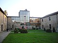
Castle of Nedde
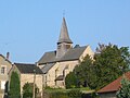
Saint Martin Church


Web links
Commons : Nedde - collection of images, videos and audio files