
Flavignac
| Flavignac | ||
|---|---|---|
|
||
| region | Nouvelle-Aquitaine | |
| Department | Haute-Vienne | |
| Arrondissement | Limoges | |
| Canton | Saint-Yrieix-la-Perche | |
| Community association | Pays de Nexon-Monts de Châlus | |
| Coordinates | 45 ° 42 ′ N , 1 ° 6 ′ E | |
| height | 276-410 m | |
| surface | 30.79 km 2 | |
| Residents | 1,061 (January 1, 2017) | |
| Population density | 34 inhabitants / km 2 | |
| Post Code | 87230 | |
| INSEE code | 87066 | |
.JPG) Flavignac |
||

Flavignac is a municipality in France . It belongs to the Nouvelle-Aquitaine region . to the Haute-Vienne , the Limoges arrondissement and the Saint-Yrieix-la-Perche canton . It borders on Séreilhac to the north, Saint-Martin-le-Vieux to the north-east, Lavignac and Meilhac to the east, Nexon and Rilhac-Lastours to the south-east, Les Cars to the south and Pageas to the west . The inhabitants call themselves Flavignacois or Flavignacoises. The municipality of Flavignac is located in the Périgord-Limousin Regional Nature Park .
Population development
| year | 1962 | 1968 | 1975 | 1982 | 1990 | 1999 | 2008 | 2013 |
|---|---|---|---|---|---|---|---|---|
| Residents | 1,165 | 1.005 | 969 | 963 | 909 | 955 | 1,045 | 1,040 |
Attractions
- Saint-Pierre-ès-Liens Church, Monument historique
- Saint-Vierge Church, Monument historique

Saint-Pierre-ès-Liens church
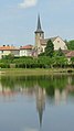
Saint-Vierge church. The lake in the foreground is called Étang Saint-Fortunat .

school


Web links
Commons : Flavignac - collection of images, videos and audio files