
Saint-Denis-des-Murs
| Saint-Denis-des-Murs | ||
|---|---|---|
|
||
| region | Nouvelle-Aquitaine | |
| Department | Haute-Vienne | |
| Arrondissement | Limoges | |
| Canton | Saint-Léonard-de-Noblat | |
| Community association | Noblat | |
| Coordinates | 45 ° 47 ' N , 1 ° 33' E | |
| height | 269-478 m | |
| surface | 23.81 km 2 | |
| Residents | 529 (January 1, 2017) | |
| Population density | 22 inhabitants / km 2 | |
| Post Code | 87400 | |
| INSEE code | 87142 | |

Saint-Denis-des-Murs is a commune in France . It belongs to the Nouvelle-Aquitaine region , the Haute-Vienne department , the Limoges arrondissement and the Saint-Léonard-de-Noblat canton .
Geography and infrastructure
The Maulde forms the municipal boundary in the northeast. In town, a railway line with a local train station runs parallel to the Vienne . The Vienne takes up the Combade as a left tributary to the east of Saint-Denis-des-Murs . The neighboring municipalities are Eybouleuf in the northwest, Saint-Léonard-de-Noblat in the north, Champnétery in the northeast, Bujaleuf in the east, Masléon in the southeast, Roziers-Saint-Georges and Saint-Bonnet-Briance in the south, Saint-Paul in the southwest and La Geneytouse to the west.
Population development
| year | 1962 | 1968 | 1975 | 1982 | 1990 | 1999 | 2008 | 2013 |
|---|---|---|---|---|---|---|---|---|
| Residents | 718 | 635 | 549 | 512 | 486 | 449 | 507 | 529 |
Attractions
- Saint-Denis church
- Former rectory
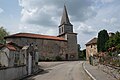
Saint-Denis church
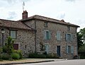
Former rectory

