
Rilhac-Lastours
| Rilhac-Lastours | ||
|---|---|---|
.svg)
|
|
|
| region | Nouvelle-Aquitaine | |
| Department | Haute-Vienne | |
| Arrondissement | Limoges | |
| Canton | Saint-Yrieix-la-Perche | |
| Community association | Pays de Nexon-Monts de Châlus | |
| Coordinates | 45 ° 39 ′ N , 1 ° 7 ′ E | |
| height | 315-557 m | |
| surface | 16.32 km 2 | |
| Residents | 371 (January 1, 2017) | |
| Population density | 23 inhabitants / km 2 | |
| Post Code | 87800 | |
| INSEE code | 87124 | |
 Rilhac-Lastours |
||

Rilhac-Lastours , in Occitan "Rilhac las Tors", is a municipality in France . It belongs to the Nouvelle-Aquitaine region , the Haute-Vienne department and the Limoges arrondissement . The municipality is located in the Périgord-Limousin Regional Nature Park, created by decree of August 24, 2011 . It was defeated in 2015 to the canton of Saint-Yrieix-la-Perche . The neighboring communities are Les Cars in the north-west, Flavignac in the north, Nexon in the north-east, Saint-Hilaire-les-Places in the east and Bussière-Galant in the south-west.
history
The village was called "Rilhac-Chaumière" during the French Revolution .
Population development
| year | 1962 | 1968 | 1975 | 1982 | 1990 | 1999 | 2007 | 2013 |
|---|---|---|---|---|---|---|---|---|
| Residents | 497 | 416 | 356 | 321 | 302 | 313 | 338 | 375 |
Attractions
- Lastours castle ruins, monument historique
- Saint-Pierre-ès-Liens Church, Monument historique
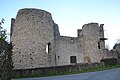
Lastours castle ruins
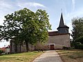
Saint-Pierre-ès-Liens church


Web links
Commons : Rilhac-Lastours - collection of images, videos and audio files