
Saint-Auvent
| Saint-Auvent | ||
|---|---|---|

|
|
|
| region | Nouvelle-Aquitaine | |
| Department | Haute-Vienne | |
| Arrondissement | Rochechouart | |
| Canton | Rochechouart | |
| Community association | Ouest Limousin | |
| Coordinates | 45 ° 48 ' N , 0 ° 56' E | |
| height | 194-348 m | |
| surface | 33.46 km 2 | |
| Residents | 962 (January 1, 2017) | |
| Population density | 29 inhabitants / km 2 | |
| Post Code | 87310 | |
| INSEE code | 87135 | |

Saint-Auvent is a commune in France . It belongs to the Nouvelle-Aquitaine region , the Haute-Vienne department , the Rochechouart arrondissement and the Rochechouart canton . The residents call themselves Auventais or Auventaises.
geography
The place is on the Gorre River . The commune is bordered by Chaillac-sur-Vienne to the northwest , Saint-Martin-de-Jussac to the north, Saint-Martin-de-Jussac to the northeast, Saint-Cyr to the east, and Saint-Laurent-sur- Gorre , in the south on Oradour-sur-Vayres , in the southwest on Vayres and in the west on Rochechouart and is located in the Périgord-Limousin Regional Nature Park .
Population development
| year | 1962 | 1968 | 1975 | 1982 | 1990 | 1999 | 2008 | 2013 |
|---|---|---|---|---|---|---|---|---|
| Residents | 1,013 | 924 | 777 | 813 | 817 | 837 | 925 | 966 |
Attractions
- Saint-Auvent Castle, Monument historique
- Chez Moutaud Dolmen , Monument historique
- Menhir de Chez Moutaud, Monument historique
- Saint-François-de-Sales church
- The sanctuary of Sanctuaire Notre-Dame de la Paix with the Notre-Dame-de-la-Paix chapel

Saint-Auvent Castle
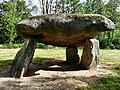
Dolmen de Chez Moutaud

Menhir de Chez Moutaud

Sanctuary of the Sanctuaire Notre-Dame de la Paix
Notre-Dame-de-la-Paix chapel


