Pensol
| Pensol | ||
|---|---|---|

|
|
|
| region | Nouvelle-Aquitaine | |
| Department | Haute-Vienne | |
| Arrondissement | Rochechouart | |
| Canton | Rochechouart | |
| Community association | Ouest Limousin | |
| Coordinates | 45 ° 37 ′ N , 0 ° 50 ′ E | |
| height | 288-382 m | |
| surface | 15.04 km 2 | |
| Residents | 180 (January 1, 2017) | |
| Population density | 12 inhabitants / km 2 | |
| Post Code | 87440 | |
| INSEE code | 87115 | |
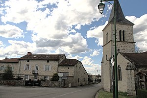
 Center of Pensol |
||
Pensol , Occitan Pansòu is a French commune in the Haute-Vienne in the region Nouvelle-Aquitaine . It belongs to the Arrondissement of Rochechouart and the Canton of Rochechouart . The responsible community association is the Communauté de communes Ouest Limousin .
geography
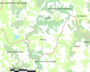
Pensol is a border municipality to the Dordogne department and is surrounded by the following 5 neighboring municipalities:
| Marval | Marval | La Chapelle-Montbrandeix |

|
Mialet (Dordogne) | |
| Abjat-sur-Bandiat (Dordogne) | Saint-Saud-Lacoussière (Dordogne) |
It is 43 kilometers to the prefecture town of Limoges in the northeast . Nontron in the Dordogne department is 15 kilometers to the southwest.
The municipality of Pensol includes the following hamlets, farms, mills, a forge and landmarks: Beaulieu, Bois du Theillaud, Chante-Alouette, Forêt de l'Épinassie, La Boucherie, La Forge de Jacques, La Lègerie, La Redoute de Coligny, La Serve , La Tuilerie, Le Bois des Roses, Le Chatain, Le Fermigier (ruin), Le Moulin, Les Fougères, Les Petites Landes, Les Simoulies, Les Tâches, Masbenat, Masgonty, Masrembert, Mazièras, Sainte-Catherine and Savalou .
The topographically deepest point at 288 meters is on the Bandiat in the extreme southwest. The highest point at 382 meters is in the northeast corner on the D 15 at Les Trois Cerisiers . The absolute height difference is 94 meters.
Transport links
The municipality of Pensol is located a little off major traffic axes. The D 85 or D 6 b from Nontron to Châlus passes on the south-eastern edge of the municipality and is reached from the town center in an easterly direction via the D 15 at Les Trois Cerisiers . On the other hand, the D 15 leads northwest towards Marval and on to Piégut-Pluviers . The D 67 leaves the town center to the south in the direction of Saint-Saud-Lacoussière and at the same time creates another connection to the Nontron-Châlus cross-connection.
Long-distance hiking trails
The GR 4 long-distance hiking trail from Royan to Grasse , which coincides with the GR 654 , runs right through the center of Pensol .
Hydrography
The Bandiat flows through Pensol to the southwest in the direction of Abjat-sur-Bandiat. The central part of the municipality is drained to the west by the Gamoret - a left tributary of the Bandiat.
geology
The municipality of Pensol lies entirely on the crystalline, Variscan basement of the northwestern Massif Central , which forms a bulge here - the Saint-Mathieu-Dom . The cathedral structure is characterized by the Saint-Mathieu leukogranite , which penetrated into the mica slate of the parautochthonous mica slate unit in the Upper Carboniferous . The center of Pensol lies on the coarse-grained normal facies of the leuco granite . On the western edge near Les Fougères , the Piégut-Pluviers granodiorite is just touched in its coarse-grained normal facies, which is separated from the leuco granite by a north-northeast trending fault . The leuco granite occurs in the contact area of the two granitoids in its fine-grain facies ( Champniers-Reilhac leuco granite ).
The parautochthonous mica schists take up the entire east and south-east section of the municipality and also appear in an isolated deposit within the leuco granite near La Redoute de Coligny . Its foliation strikes north, north-north-west to north-west and dips at 35 to 50 degrees to the east or north-east. Linear stretch within the foliation plane face east. The degree of metamorphosis increases to the southwest - here the staurolite isograde was exceeded (transition from the albite to the staurolite zone ).
The faults in the basement are mostly north-north-east-south-south-west, occasionally the north-east direction is taken. The latter direction is also followed by the contact between leuco granite and mica schist in the south of the town center.
ecology
The municipality of Pensol is an integral part of the Périgord-Limousin Regional Nature Park .
Population development
| Population development in Pensol | ||
|---|---|---|
| year | Residents |

|
| 1962 | 312 | |
| 1968 | 260 | |
| 1975 | 237 | |
| 1982 | 225 | |
| 1990 | 220 | |
| 1999 | 177 | |
| 2006 | 182 | |
| 2007 | 183 | |
| 2008 | 184 | |
| 2013 | 184 | |
| 2017 | 180 | |
Source: INSEE
The population of the municipality of Pensol has generally declined since 1962 (population loss of 42 percent), with a slight trend reversal observed between 1999 and 2013.
mayor
The mayor of Pensol has been the non-party Paul Daniel Brachet since March 2016.
Attractions
- Saint-Cloud church
literature
- B. Briand et al. a .: Feuille Châlus . In: Carte géologique de la France at 1/50 000 . BRGM.


