
GR 654
| GR 654 | |
|---|---|
.jpg) The Belfry of Namur |
|
| Data | |
| length | 1750 km |
| location | Belgium , France |
| Starting point |
Namur 50 ° 28 ′ 0 ″ N , 4 ° 52 ′ 0 ″ E |
| Target point |
Montréal-du-Gers 43 ° 57 ′ 3 ″ N , 0 ° 12 ′ 11 ″ E |
| Type | Long-distance hiking trail |
| Level of difficulty | moderate |
| Months | all year round |
The GR 654 ( French Grande Randonnée 654 ) is a GR long-distance hiking trail that connects Namur in Belgium with Montréal-du-Gers in the Gers department in France. The distance between the province of Namur and southwestern France is 1750 kilometers. The route makes it possible to connect from Belgium to the Camino de Santiago to Santiago de Compostela . He himself partly follows the Via Lemovicensis .
Route
The long-distance hiking trail GR 654 touches the following cities:
From Vézelay to Périgueux , the route partly follows the Via Lemovicensis.
At the end point in Montréal-du-Gers, the Via Podiensis and the GR 65 are connected .
Sights along the long-distance hiking trail

The following sights , which are UNESCO World Heritage sites, are located on the GR 654 :
- the Belfry of Namur
- the Notre-Dame cathedral , the abbey Saint-Remi and the Palace of Tau in Reims
- the Notre-Dame-en-Vaux collegiate church in Châlons-en-Champagne
- the church of Saint-Jacques-le-Majeur in Asquins
- the basilica of Sainte-Marie-Madeleine in Vézelay
- the priory church of Sainte-Croix-Notre-Dame in La Charité-sur-Loire
- the collegiate church of Saint-Étienne (formerly Saint-Jacques) in Neuvy-Saint-Sépulchre
- the collegiate church of Saint-Léonard in Saint-Léonard-de-Noblat
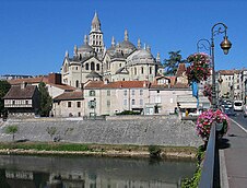
- the Saint-Front cathedral in Périgueux.
Picture gallery

Notre-Dame-en-Vaux in Châlons-en-Champagne

Basilica of Sainte-Marie-Madeleine in Vézelay

Sainte-Croix-Notre-Dame in La Charité-sur-Loire

Saint-Léonard in Saint-Léonard-de-Noblat
Saint-Front cathedral in Périgueux


