
Saint-Mathieu (Haute-Vienne)
| Saint-Mathieu | ||
|---|---|---|

|
|
|
| region | Nouvelle-Aquitaine | |
| Department | Haute-Vienne | |
| Arrondissement | Rochechouart | |
| Canton | Rochechouart | |
| Community association | Ouest Limousin | |
| Coordinates | 45 ° 42 ′ N , 0 ° 46 ′ E | |
| height | 225-438 m | |
| surface | 40.39 km 2 | |
| Residents | 1,080 (January 1, 2017) | |
| Population density | 27 inhabitants / km 2 | |
| Post Code | 87440 | |
| INSEE code | 87168 | |
 Town Hall ( Mairie ) |
||

Saint-Mathieu , Occitan Sant Matiá , is a municipality in southwest France with 1080 inhabitants (as of January 1, 2017). It belongs to the Nouvelle-Aquitaine region (before 2016 Aquitaine ), the Haute-Vienne department and the Rochechouart arrondissement . Saint-Mathieu was the chief town (chef-lieu) of the canton of Saint-Mathieu and became the canton of Rochechouart in 2015 . The responsible community association is the Communauté de communes Ouest Limousin . The inhabitants are known as Mathuséens or Mathuséennes .
etymology
Saint-Mathieu is derived from the Occitan Sant Matiá or Samatiá , that is, from Saint Matthias and not from Saint Matthew .
geography

Saint-Mathieu is 40 kilometers west-southwest of Limoges (as the crow flies) and is a border municipality to the Dordogne department . Nontron in the south is 20 kilometers away.
The commune of Saint-Mathieu is surrounded by the following seven communes:
| Chéronnac , Saint-Bazile | ||
| Maisonnais-sur-Tardoire |
.svg)
|
Cussac |
| Champniers-et-Reilhac (Dordogne) | Saint-Barthélemy-de-Bussière (Dordogne) | Marval |
The municipality of Saint-Mathieu claims a very large area with 40.39 square kilometers. In terms of area, it is the second largest municipality in the canton of Rochechouart and the third largest in the Arrondissement of Rochechouart.
It includes the following hamlets, farms, castles, a mill and landmarks: Bayeras , Beauséjour , Bois de l'Autre , Bois de Palivaud , Bois des Forts , Bois Sec , Cautarial , Chambonnaud , Chambouraud , Château Rocher , Château Séchères , Chez Bécassou , Chez Chabert , Chez Goursaud , Chez Nadaud , Chez Rouchaud , Chez Tamagnon , Chez vignette , Concoure , Coulerède , Excideuil , Fonsoumagne , Fontandreau , Fontetru , Forêt de Puy skin , Grateloube , Grueto , Jarlat , Junicaud , L'Épurdie , L ' Étaboulie , La Beille , La Besse , La Borderie , La Boulie , La Brousse , La Côte , La Croix de Labran , La Carabine , La Couade , La Forge , La Gerbaudie , La Lande , La Marchaderie , La Pêcherie , La Planche du Loup , La Serve , La Terminière , Lascaux , Laubarias , Le Bournat , Le Clos du Got , Le Coin du Parc , Le Grand Peyrouteau , Le Grand Sauvot , Le Moulin du Pont , Le Pêcher , Le Petit Peyrouteau , Le Petit Sauvot , Le Peyrat , Le Pissarou , Le Semelier , Les Brousses , Les Bussièr es , Les Cailloux , Les Chabaudies , Les Champs , Les Defaix , Les Flamanchies , Les Garennes , Les Gironneaux , Les Gustins , Les Landes , Les Ourgeaux , Les Perrières , Les Petites Forêts , Les Refours , Les Souchous , Les Thermes , Les Tourettes , Monteau , Neuville , Pérantonie , Pierregreffier , Puisseger , Puy Haut , Puysseguy , Rouyaflamas and Vieilleville .
The topographically lowest point of the municipality of Saint-Mathieu is 225 meters above sea level on the Tardoire in the extreme northwest, the highest point at 438 meters on the Puy Haut in the southeast. This ridge already belongs to the Monts de Châlus . The maximum difference in altitude is 210 meters.
Transport links

The D 675 from Rochechouart to Nontron runs through the center of Saint-Mathieu in a northeast-southwest direction. Furthermore, the D 699 crosses in an east-west direction from Cussac to Montbron . The D 87 leaves Saint-Mathieu north towards Chérronac. The D 67 connects the town center with Marval in the south. A communal road connects Saint-Mathieu with Maisonnais-sur-Tardoire in the west.
Hydrography
The border river to the northern neighboring communities Chéronnac and Saint-Bazile is the Tardoire , which generally drains to the northwest. Its left tributary, the Colle , also flows off to the northwest. It is dammed about 2 kilometers northeast of the town center to Lac de Saint-Mathieu . The southern border river to Champniers-et-Reilhac is the Nauzon , which drains to the west . This splits into small tributaries in the municipality - on the left into the Samaritaine and on the right into the Ruisseau de l'Étang Neuf , which continues the border with Champniers-et-Reilhac. The upper reaches of the Nauzon are known as Ruisseau de l'Étang de l'Étourneau and are dammed up to form many small ponds.
geology

Saint-Mathieu lies entirely on the crystalline, Variscan basement of the northwestern Massif Central , which forms a bulge here - the Saint-Mathieu Cathedral . The dome structure consists of the Saint-Mathieu leukogranite , which has penetrated into the mica slate of the parautochthonous mica slate unit in the Upper Carboniferous . The mica schists are present in the east of the municipality, smaller islands are mainly enclosed in the leuco granite around Fonsoumagne . They generally strike southeast-northwest and dip at 30 to 70 degrees to the northeast, but at Chez Chabert they turn in the east-west direction with a dip to the north. At the extreme northeast edge of the municipality near Le Grand Sauvot , eye gneisses of the lower gneiss cover of the Limousin can also be observed, which were pushed onto the mica slate in a west to south-westerly direction. They also have leuco granite islands. The leukogranite occurs predominantly in its medium to coarse-grained normal facies, but occasionally also in fine-grained form as Champniers-et-Reilhac leukogranite such as in Les Gustins . It is traversed by numerous steep micro-granite tunnels, which mostly follow the north-northeast or north-northwest direction. Quartz veins and pegmatites also appear occasionally in the leuco granite.
ecology
The commune of Saint-Mathieu forms an integral part of the Périgord-Limousin Regional Natural Park .
history
The oldest traces of settlement in the commune of Saint-Mathieu go back to the Iron Age . Several tumuli containing a burial chamber were found . The burial chambers were equipped with stone axes and burial urns. The tumuli were located along the ridge between Saint-Mathieu and La Chapelle-Montbrandeix and followed Celtic routes which, for safety reasons, always preferred high altitudes over valleys.
The remains of a villa from the Gallo-Roman era were found at Les Bussières - roof tiles and stumps.
The current town center experienced rapid development in the Middle Ages . The Romanesque local church was built in the 12th century . A fortified castle was built behind the church in 1373, which belonged to the Vigier family. It joins a chain of fortifications in the Charente-Limousin-Périgord border area. Almost nothing is left of it today, the last tower was demolished in 1927. In 1486 the church was rebuilt and expanded. Thanks to rich natural resources, a small iron-processing industry was established in Saint-Mathieu during the Middle Ages, which specialized in the manufacture of chain mail. Blacksmiths were in existence at La Couade , Le Buisson and Séchères until 1860.
Population development
| Population development in Saint-Mathieu | ||||
|---|---|---|---|---|
| year | Residents | Population in the canton in percent |
Population density |

|
| 1962 | 1711 | 37.4 | 42.4 / km² | |
| 1968 | 1613 | 31.4 | 39.9 / km² | |
| 1975 | 1483 | 32.5 | 36.7 / km² | |
| 1982 | 1364 | 33.6 | 33.8 / km² | |
| 1990 | 1271 | 34.7 | 31.5 / km² | |
| 1999 | 1233 | 36.2 | 30.5 / km² | |
| 2004 | 1188 | 29.4 / km² | ||
| 2008 | 1171 | 29.0 / km² | ||
| 2009 | 1164 | 28.8 / km² | ||
| 2013 | 1120 | 27.7 / km² | ||
| 2014 | 1099 | 27.2 / km² | ||
| 2015 | 1087 | 26.9 / km² | ||
| 2017 | 1080 | 26.7 / km² | ||
Source: INSEE
The population of the commune of Saint-Mathieu has been decreasing since 1962 (population loss of 37 percent), but its decline has slowed since 1990.
mayor
The DVG nurse Agnès Varachaud has been mayor of Saint-Mathieu since March 2014 .
2017 presidential election
| Candidates | Parties | 1st ballot | 2nd ballot | ||||
|---|---|---|---|---|---|---|---|
| be right | % | be right | % | ||||
| Emmanuel Macron | En marche! | EM | 136 | 21.32% | 336 | 59.15% | |
| Marine Le Pen | Front national | FN | 162 | 25.39% | 232 | 40.85% | |
| Jean-Luc Mélenchon | Front de gauche | FDG | 124 | 19.44% | |||
| François Fillon | Les Républicains | LR | 118 | 18.50% | |||
| Benoît Hamon | Parti socialist | PS | 30th | 4.70% | |||
| Nicolas Dupont-Aignan | Debout la République | DLR | 29 | 4.55% | |||
| Nathalie Arthaud | Lutte Ouvrière | LO | 17th | 2.66% | |||
| Jean Lassalle | Resistons! | R. | 13 | 2.04% | |||
| Philippe Poutou | Nouveau Parti anticapitaliste | NPA | 5 | 0.78% | |||
| François Asselineau | Union popular republicaine | UPR | 4th | 0.63% | |||
| Jacques Cheminade | Solidarité et Progrès | SP | 0 | 0.00% | |||
| total | 638 | 100% | 568 | 100% | |||
| Valid votes | 638 | 80.45% | 568 | 71.63% | |||
| Invalid votes | 28 | 3.53% | 80 | 10.09% | |||
| voter turnout | 666 | 83.98% | 648 | 81.72% | |||
| Abstentions | 127 | 16.02% | 145 | 18.28% | |||
| Registered voters | 793 | 793 | |||||
Attractions
- The church of Saint-Mathieu
- The Château Rocher castle
- The Lac de Saint-Mathieu reservoir .
Photo gallery
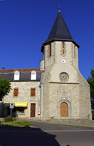 The church of Saint-Mathieu
 South portal
 Center of Saint-Mathieu
 Bridge over the Tardoire at Le Moulin du Pont
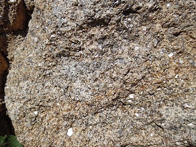 Saint-Mathieu leuco granite in coarse-grained normal facies
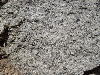 Fine-grain facies of the Saint-Mathieu-Leukogranite


