
Champniers-et-Reilhac
| Champniers-et-Reilhac | ||
|---|---|---|
|
||
| region | Nouvelle-Aquitaine | |
| Department | Dordogne | |
| Arrondissement | Nontron | |
| Canton | Périgord Vert Nontronnais | |
| Community association | Périgord Nontronnais | |
| Coordinates | 45 ° 40 ′ N , 0 ° 44 ′ E | |
| height | 185-360 m | |
| surface | 20.40 km 2 | |
| Residents | 455 (January 1, 2017) | |
| Population density | 22 inhabitants / km 2 | |
| Post Code | 24360 | |
| INSEE code | 24100 | |

Champniers-et-Reilhac , Occitan Champs Niers e Relhac is a French municipality with 455 inhabitants (at January 1, 2017) in the Dordogne in the region Nouvelle-Aquitaine (before 2016 Aquitaine ). It belongs to the Arrondissement of Nontron and the canton of Périgord Vert Nontronnais (until 2016 Bussière-Badil ). The responsible community association is the Communauté de communes du Périgord Nontronnais . The inhabitants are known as Champniérois or Champniéroises .
etymology
The place name Champniers is derived from the Occitan Champs niers , French champs noirs . Black floors are meant , i.e. H. Good quality floors. The place name Relhac or Reilhac probably comes from a Gallo-Roman proper name Regilius or Regulius , with the suffix -acum as a place name or claim to ownership.
geography

The current municipality of Champniers-et-Reilhac emerged in 1806 from the amalgamation of the two previously independent municipalities of Champniers and Reilhac ; the new municipality was then still called Reilhac-et-Champniers . It was not until 1847 that the current spelling Champniers-et-Reilhac was introduced. The two villages are almost five kilometers apart, with Reilhac being off the main traffic artery D 675 .
The commune of Champniers-et-Reilhac borders the Haute-Vienne department . Reilhac is the northernmost village in the Dordogne department. It is 18 kilometers to Montbron in the Charente department in the west, and only 5 kilometers (as the crow flies) to Saint-Mathieu in the north-northeast. Nontron in the southwest is 21 kilometers away.
Champniers-et-Reilhac is surrounded by the following five municipalities:
| Maisonnais-sur-Tardoire (Haute-Vienne) | Maisonnais-sur-Tardoire (Haute-Vienne) | Saint-Mathieu (Haute-Vienne) |
| Busserolles |
.svg)
|
|
| Piégut-Pluviers | Piégut-Pluviers | Saint-Barthélemy-de-Bussière |
The following hamlets, farms, mills and landmarks are located in the municipality of Champniers-et-Reilhac: Belair , Beyranne , Chantelouve , Chèvre Morte , Chez Gonneau , Chez Tendeau , Étang de Pouyol , Fraisse , Gué du Bost , La Chabanne , La Chabroulie , La Chapaudie , La Coudenie , La Francherie , La Parentie , La Petite Chabane , La Trémoulie , Laubergie , Le Bost , Le Calvaire , Le Cluzeau , Le Grafeuil , Le Grand Bost , Le Moulin de la Chabroulie , Le Puy , Les Brousses , Les Fougères , Les Juries , Les Maisonnettes , Les Métairies , Les Petites Brousses , Les Petits Moulins , Les Prades , Les Simonies , Les Tamouzies , Maison Seule , Maisonneuve , Marcillac , Papey and Puyfaud .
The topographically deepest point of the municipality is 185 meters above sea level at the confluence of the Trieux and Nauzon in the far west. The highest point with 360 meters above sea level is at the extreme east point of the municipality. This reflects the generally clod-like inclination of the landscape towards the west. The maximum difference in altitude is 175 meters. Champniers lies at 290 meters, Reilhac at 247 meters above sea level.
Transport links

The north-south axis D 675 from Nontron to Saint-Mathieu runs through Champniers . The secondary road D 111 / D 117 creates an eastern cross-connection in the direction of Cussac , the D 110 leads west to the district of Reilhac and then on to Maisonnais-sur-Tardoire. Busserolles is reached in the west via the D 90 .
Hydrography
The south-west of the municipality is drained by the Trieux , a left tributary of the Tardoire , towards the north-west. At the westernmost point of the municipality the Nauzon flows , a smaller right branch of the Trieux, which also functions as a border river to the Haute-Vienne department. In the upper reaches it merges into the Ruisseau de l'Étang Neuf , which forms the further course of the border. In the southwest there are also two smaller reservoirs, L'Étang des Petits Moulins and L'Étang Grolhier - the latter is an important bird sanctuary.
The general direction of drainage is to the west.
geology

The municipality of Champniers-et-Reilhac is completely underlain by Variscan basement rocks of the north-western Massif Central . Mainly this is the Saint-Mathieu-Leukogranite with its fine-grained ( Champniers-et-Reilhac-Leukogranite - γ 2 ) and its coarse-grained facies (actual Saint-Mathieu-Leukogranite - γ 2M ). The coarse-grained facies at Les Juries contain north-north-west striking mica schists of the parautochthonous mica slate unit ( ξ 1 ) and at Les Fougères a pegmatite body turned in the north-west direction ( P ).
In the southwest the Piégut-Pluviers-Granodiorite is just exposed in its fine-grained marginal facies ( f γ 3M ) and in its coarse-grained normal facies ( γ 3M ).
In the fine-grained transition area of the two granitoids there are also traces and lenses of paragneiss ( ζ 1-2 ) and migmatitic paragneiss ( Mζ 1-2 ) in between. The transition between the paragneiss and the granodiorite at Laubergie is interesting , which takes place over a distance of a good 100 meters very successively and concordantly to the northwest-striking foliation of the paragneiss.
The granitoids are of interference and partly blade that occurring micro granite corridors running through it. The preferred strike direction is north-northwest, but northerly, north-northeast and northeast directions also occur. At Chez Tendeau , an east-south-east trending quartz vein crosses the granodiorite. Faults and dikes are the result of late Variscan expansion tectonics.
The valleys of the Nauzons and the Trieux widen shortly before their confluence. Holocene alluvium - fine sands with quartz pebbles (formation Fy-z ) - was deposited in them .
Ecology and environment
.JPG)
Natural park
The municipality has been an integral part of the Périgord-Limousin Regional Natural Park since 1998 .
Protected areas
In the municipality, the valleys of the Trieux , the Nauzon and the Ruisseau de la Francherie as well as the Étang Grolhier form an ecological protection zone (continental ZNIEFF type 1 - French zone d'interèt écologique, faunistique et floristique ). The protection zone is known in French as Vallées du réseau hydrographique de la Tardoire et du Trieux and is notable for its flora and the quality of its water.
The flora encountered comprises around 40 plant species, four of which are considered characteristic: Musk herb Adoxa moschatellina , fingered lark spur Cordyalis solida , rue mussel Isopyrum thalictroides and Atlantic hare bells Hyacinthoides non-scripta .
Since 1979 the Étang Grolhier in the southwest has been designated as a 233 hectare nature reserve (French site naturel ) (the pond itself is only 22.4 hectares).
history
The Roman road from Périgueux to Poitiers once passed near Reilhac. A villa from the Gallo-Roman period was discovered in 1922 at the Étang des Petits Moulins on the southern edge of the municipality. Reilhac has a Romanesque church from the second half of the 12th century , and Champniers also has a Romanesque church from the 12th century. The square donjon of the former castle in Champniers has been preserved.
Population development
| Population development in Champniers-et-Reilhac | ||
|---|---|---|
| year | Residents |

|
| 1962 | 694 | |
| 1968 | 661 | |
| 1975 | 554 | |
| 1982 | 548 | |
| 1990 | 544 | |
| 1999 | 533 | |
| 2007 | 508 | |
| 2008 | 504 | |
| 2012 | 500 | |
| 2013 | 497 | |
| 2015 | 478 | |
| 2017 | 455 | |
Source: INSEE
The population has generally been declining since 1962 (population loss of 34 percent), with a very sharp decline between 1968 and 1975.
With an area of 20.40 square kilometers, the population density is 22 inhabitants / km².
mayor
The mayor of Champniers-et-Reilhac has been the craftsman Daniel Védrenne, who is part of the DVD , since March 2008 .
economy
employment
In 2012, the working age population aged 15 to 64 was 185, i.e. H. 37.0% of the total population. The number of unemployed has increased from 20 to 27 in 2007, the unemployment rate is now 14.6%.
Companies and businesses
As of December 31, 2013, 62 companies were based in the municipality, 35 of them in the trade, transport or services sector, 9 in agriculture, forestry or fishing, 9 in construction, 6 in industry and 3 in the administration, education, health care or sector Social.
Attractions
- Romanesque church of Saint-Paul in Reilhac, second half of the 12th century, monument historique since 1965
- Romanesque church of Saint-Paixent in Champniers, 12th and 15th centuries, with an octagonal bell tower
- Château de Champniers , of which only the square tower has survived
- 17th century Château de Reilhac
Photo gallery
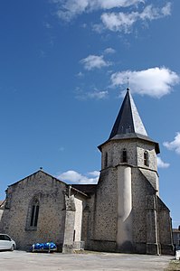
The Saint-Paixent church in Champniers

Entrance portal of Saint-Paixent

Saint-Paixent octagonal bell tower

Church tower of Saint-Paul in Reilhac

The remaining tower of the Château de Champniers
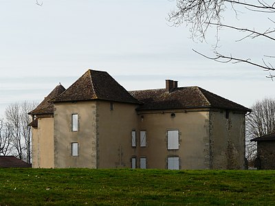
The Château de Reilhac

The center of Champniers

The Nauzon , border river to the Haute-Vienne
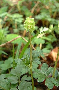
Musk herb Adoxa moschatellina

Fingered larkspur Cordyalis solida
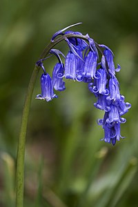
Atlantic hare bell Hyacinthoides non-scripta
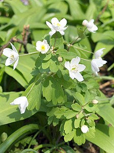
Meadow rue mussels Isopyrum thalictroides


.JPG)


.jpg)

Individual evidence
- ↑ Chantal Tanet and Tristan Hordé: Dictionnaire des noms de lieux du Périgord . éditions Fanlac, 2000, ISBN 2-86577-215-2 , p. 96 .
- ↑ Champniers-et-Reilhac on the Insee website
- ↑ Guy Penaud : Dictionnaire des châteaux du Périgord . Editions Sud Ouest, 1996, ISBN 2-87901-221-X , p. 72 .
literature
- G. Le Pochat et al. a .: Feuille Montbron . In: Carte géologique de la France at 1/50 000 . BRGM, 1986.
- Dominique Richard (Ed.): Le Guide Dordogne-Périgord . Éditions Fanlac, Périgueux 1993, ISBN 2-86577-162-8 .