
Etouars
|
Étouars Estoars |
||
|---|---|---|
|
||
| region | Nouvelle-Aquitaine | |
| Department | Dordogne | |
| Arrondissement | Nontron | |
| Canton | Périgord Vert Nontronnais | |
| Community association | Périgord Nontronnais | |
| Coordinates | 45 ° 36 ' N , 0 ° 38' E | |
| height | 170-277 m | |
| surface | 7.83 km 2 | |
| Residents | 155 (January 1, 2017) | |
| Population density | 20 inhabitants / km 2 | |
| Post Code | 24360 | |
| INSEE code | 24163 | |
 Saint-Saturnin Church |
||

Étouars , Occitan Estoars is a French municipality with 155 inhabitants (at January 1, 2017) in the Dordogne in the region Nouvelle-Aquitaine (before 2016 Aquitaine ). It belongs to the Arrondissement of Nontron and the canton of Périgord Vert Nontronnais (until 2015 Bussière-Badil ). The responsible community association is the Communauté de communes du Périgord Nontronnais . The inhabitants are known as Étouardais or Étouardaises .
geography
The municipality of Étouars, located in the north of the Périgord , is about 8 kilometers from Javerlhac and about 12 kilometers from Nontron . Closest larger cities are Angoulême (40 kilometers west) and Limoges (65 kilometers northeast of Étouars).
Étouars is surrounded by the following five municipalities:
| Bussière-Badil | Bussière-Badil | |
| Soudat |
.svg)
|
Saint-Éstèphe |
| Teyjat | Le Bourdeix |
After Connezac, Étouars is the second smallest municipality in the canton of Périgord Vert Nontronnais. Its territory includes the following hamlets, farms and brickworks: La Croix du Pêcher, La Manugrie, La Tuilière de Ribièras, La Tuilière de Rippe, Lacrète, Lavergne, Le Petit Étouars, Les Forges, Les Garennes, Les Grands Champs, Les Petits Champs , Les Quatre Routes and Ribièras .
The community occupies an average height of 262 meters above sea level. The topographically lowest point of the municipality is 170 meters above sea level on the Ruisseau de l'Étang d'Assat in the far west. The highest point at 277 meters (good vantage point to the east) is located immediately north of the town center, which was built on a ridge. These conditions reflect a generally clod-like collapse of the landscape towards the west-southwest.
Transport links

The center of Étouars is on the D 93 from Javerlhac to Piégut . The municipality is also crossed by the D 92 coming from Varaignes and the D 3 from Bussière-Badil to Nontron .
Hydrography
The natural north-west border of the municipality forms the Ruisseau de l'Étang d'Assat , part of the south-east border of the Ruisseau des Forges dammed here . The Marcourive also has its source at Lacrète .
The general direction of drainage is to the southwest.
geology
The deeper subsurface of the municipality of Étouars is formed by the Variscan basement of the north-western Massif Central - paragneiss , metatexite , leptynite and intruding granodiorite ( Piégut-Pluviers-granodiorite ).
The foliation of the metasediments generally strikes northeast and dips at 40 to 50 ° to the northwest. Your contact with the granodiorite (north of Lacrète ), which is in the east of the municipality in its coarse-grained normal facies ( γ 3M ), occurs through a north-northeast trending fault. However, due to the erosion activity of the Marcourive and its right tributary, the granodiorite spurs out far to the southwest towards Teyjat. The metatexite ( Mζ 1-2 ) is exposed along the northwest boundary at Ruisseau de l'Étang d'Assat and is traversed by a northeast trending micro -granite dike ( μ γ 3M ). The leptynite ( λ 3-4 ) appears in the extension of this micro-granite dike to the northeast, but is inserted into paragneiss ( ζ 1-2 ) by faults .
The ridge running through the town center is built up by sediments of the Hettangian ( arkoses - formation l 1-4 ) belonging to the north-eastern Aquitaine basin , which transgressed over the granodiorite here . The hettangium also appears on the right arm of the Marcourive and in two small deposits near Ribièras and Les Petits Champs . In the vicinity of the La Tuilerie de Rippe brickworks, a north-northwest trending deportation is happening. As a result, stratigraphically higher Liass layers (formation l 5-9 ), including the clay sediments of the Aalenium , are opened up - a welcome raw material for the local brickworks .
The basement is cut by the two rivers of the Marcourive and the Ruisseau de l'Étang d'Assat , but the ridge in between and the hillside location south of the Marcourive are made up of coluvial clays, sands and boulders (usually rounded quartz pebbles) of the Quaternary (Formations C and HC ) completely masked. These colluvial, sloping sediments of the Pleistocene can be replaced by Eocene / Pliocene alluvium (sands and gravels of the HF formation ) (near La Croix du Pêcher ).
ecology

Natural park
The municipality of Étouars has been an integral part of the Périgord-Limousin Regional Nature Park since 1998 .
Protected area
Under conservation , the Talungen the stand Ruisseau des Forges , the Ruisseau de l'Etang d'Assat and the Marcourive . These areas are designated as continental ZNIEFF (French zone naturelle d'intérêt écologique, faunistique et floristique ) of type 1 under the name Vallées du réseau hydrographique du Bandiat . Its flora consists of more than 100 plant species with large ormennig ( Agrimonia procera ) and Atlantic hare bells ( Hyacinthoides non-scripta ) as indicator plants.
history
There are no direct traces of settlement from prehistoric times in Étouars, but judging by finds in neighboring municipalities, the municipality of Étouars should also have been inhabited by people at that time. There are finds from the Gallo-Roman period . The construction of the church began in the Middle Ages . Étouars gained importance between the 15th century and the 18th century as a site of iron smelting . In the hamlet of Les Forges , iron ore from the Nontronnais was melted in blast furnaces ( cast iron ) and processed into cannons for the French Navy in Rochefort . The forge was operated with water power, the charcoal required for the reduction came from the surrounding forest areas, the Jura limestone from the communities further west served as a flux additive. The cannons were shipped overland to the Charente and then reached Rochefort by boat.
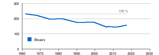
Population development
| Population development in Étouars | ||||
|---|---|---|---|---|
| year | Residents |
|
||
| 1962 | 230 | |||
| 1968 | 220 | |||
| 1975 | 195 | |||
| 1982 | 197 | |||
| 1990 | 174 | |||
| 1999 | 175 | |||
| 2006 | 144 | |||
| 2007 | 147 | |||
| 2008 | 145 | |||
| 2011 | 144 | |||
| 2013 | 146 | |||
| 2015 | 151 | |||
| 2016 | 154 | |||
| 2017 | 155 | |||
Source: INSEE
The population development is generally declining with slight fluctuations.
With an area of 7.83 square kilometers, the population density is 20 inhabitants / km².
mayor
Acting mayor since March 2008 is Francine Bernard , a member of the Front de gauche .
Attractions
One of the cannons cast in Étouars is on display in the square next to the Saint-Saturnin church . In addition, an experimental blast furnace was built and put into operation. The Fer et Forges (iron and forging) museum provides important background information on the iron smelting in the Haut Périgord at that time . The actual forge is located on the D 3 south of the town center. Several buildings and facilities have been preserved here, such as the manor house, the storage halls for the charcoal, sewer systems, a small blast furnace and the reservoir with its former dam.
Also worth seeing is a large orchard for old pome fruit varieties on the western edge of the village.
Photo gallery

The Ruisseau des Forges dammed up for the forge

Entrance portal of Saint-Saturnin

capital

Blacksmith's shop with mansion and outbuildings

The experimental blast furnace on the village square

Melting result of the experimental blast furnace

Single-use melting furnace

Former forge


literature
- Gilbert Le Pochat: Géologique de la France à 1/50 000. Feuille Montbron . BRGM, 1986.
Web links
- Website with Occitan place names in the Dordogne department
- Étouars on the annuaire-mairie.fr website
- Étouars on cartesfrance.fr in French
- Population development since 1793 on cassini.ehess.fr