
Augignac
| Augignac | ||
|---|---|---|

|
|
|
| region | Nouvelle-Aquitaine | |
| Department | Dordogne | |
| Arrondissement | Nontron | |
| Canton | Périgord Vert Nontronnais | |
| Community association | Périgord Nontronnais | |
| Coordinates | 45 ° 36 ' N , 0 ° 42' E | |
| height | 189-306 m | |
| surface | 22.64 km 2 | |
| Residents | 814 (January 1, 2017) | |
| Population density | 36 inhabitants / km 2 | |
| Post Code | 24300 | |
| INSEE code | 24016 | |

Augignac , Occitan Auginhac is a French municipality with 814 inhabitants (at January 1, 2017) in the Dordogne in the region Nouvelle-Aquitaine (before 2016 Aquitaine ). It belongs to the Arrondissement of Nontron and since March 2015 to the canton of Périgord Vert Nontronnais (until 2015 canton of Nontron ). The responsible community association is the Communauté de communes du Périgord Nontronnais . The inhabitants are called Augignacois or Augignacoises .
etymology
The place name Augignac is probably derived from the Gallic or Germanic proper name Algeinus or Adgennus , possibly also from a Gallo-Roman proper name Aligenus , followed by the suffix -acum (now -ac), which denotes an estate. In 1315, today's Augignac is first mentioned as Auginhac and 50 years later in the Latinized form Auguilhacum . In 1864 the community was still called Auginiac .
geography
Augignac is located in the Périgord Vert and in the Périgord-Limousin Regional Nature Park and is about ten kilometers from the south-southwest Nontron and about five kilometers from the Piégut-Pluviers in the north .
Augignac is surrounded by the following seven municipalities:
| Bussière-Badil | Piégut-Pluviers | Abjat-sur-Bandiat |
| Saint-Estèphe |
.svg)
|
Abjat-sur-Bandiat |
| Le Bourdeix | Nontron | Savignac-de-Nontron |
The municipal area of Augignac includes the following hamlets, farmsteads, mills, castles and landmarks: Bel-Air , Bois de Château Reynaud , Boudignac , Château Reynaud , Chez Pey , Clos Neuf , Étang des Merles , Étang Millau , Font de Pique , La Beaufarie , La Cornadelle , La Ferrière , La Franche , La Garde , La Petite Tavernerie , La Tavernerie , Lacour , Lafarge , Lapeyre , Laubanie , Le Clos des Landes , Le Clos Neuf , Le Fagnou , Le Ménichou , Le Moulin de Lapeyre , Le Moulin de Nebout , Le Moulin de Tignac , Le Point du Jour , Le Semis , Le Tupet , Les Brégères , Les Chadauds , Les Landes , Les Moutas , Les Petits Champs , Leygurat , Maine du Bost , Maison Neuve , Manzac , Nauvialle , Pouzol , Puy du Pin , Puybégout , Roc de Poperdu , Rochefoulée , Rochers de Rochezide , Roubardières and Tignac .
The topographically lowest point of the municipality is 192 meters above sea level on the Bandiat in the south. The highest point at 306 meters above sea level is near Laubanie in the north. The absolute height difference is 114 meters. The town center is at 271 meters above sea level.
Transport links

The D 675 runs through the center of Augignac from Rochechouart to Nontron (in a north-south direction). The town center is also crossed by a municipal road running in an east-west direction from Abjat-sur-Bandiat to Saint-Estèphe.
Long-distance hiking trail
The municipality is crossed by the GR 4 long-distance footpath from Royan to Grasse .
Hydrography
The southeast border of the municipality to Abjat-sur-Bandiat is formed by the Bandiat, which drains to the southwest . In the northwest, the Doue forms the border with Piégut-Pluviers and Saint-Estèphe. It also flows in a south-westerly direction. The municipal area is therefore on a ridge between the two mentioned rivers; this ridge gradually becomes lower towards the south-southwest.
geology

Augignac lies entirely on the Piégut-Pluviers-Granodiorit , which belongs to the basement of the northwestern Massif Central and which is predominantly found in its coarse-grained normal facies ( γ 3M ) in the municipality . At Puybégout , however, the coarse-grained porphyry facies ( p γ 3M ) are exposed . The town center is traversed by several pink microgranite dikes ( μ γ ) in the NNW and NNE directions and several faults in the NW, NNW and N directions. The more or less vertical corridors show thicknesses in the decimeter to meter range.
The expanding Bandiattal east of Les Chadauds is filled by Holocene alluvium (Formation Fz ).
ecology
Natural park
Augignac has been part of the Périgord-Limousin Regional Nature Park since 1998 .
Protected area
The Bandiattal in the east, the downstream part of its two right tributaries, the valley of the Doue in the west and the lower reaches of one of its left tributaries are under nature protection . These areas are designated as continental ZNIEFF (French zone naturelle d'intérêt écologique, faunistique et floristique ) of type 1 under the name Vallées du réseau hydrographique du Bandiat . Its flora consists of more than 100 plant species with large ormennig ( Agrimonia procera ) and Atlantic hare bells ( Hyacinthoides non-scripta ) as indicator plants.
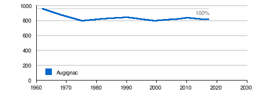
Population development
| Population development in Augignac | ||||
|---|---|---|---|---|
| year | Residents |
|
||
| 1962 | 954 | |||
| 1968 | 876 | |||
| 1975 | 791 | |||
| 1982 | 818 | |||
| 1990 | 838 | |||
| 1999 | 791 | |||
| 2005 | 811 | |||
| 2006 | 811 | |||
| 2010 | 836 | |||
| 2015 | 815 | |||
| 2016 | 814 | |||
| 2017 | 814 | |||
Source: INSEE
The population of Augignac was declining until 1975. Since then, they have stabilized again with slight fluctuations.
With an area of 22.64 square kilometers, the population density is 36 inhabitants / km².
economy
employment
In 2013, the working age population aged between 15 and 64 was 486 (75.1% of the total population), of which 365 were employed, which corresponds to 64.8% of the total population. 50 people were registered as unemployed (13.7% of employees), an increase of 25 people compared to 2007 (7.0% of employees).
Companies
As of December 31, 2013, 74 companies were located in the municipality, 44 of them in trade, transport and services, 13 in construction, 8 in industry, 5 in agriculture, forestry or fishing and 4 in administration, education, health or social welfare.
mayor
Mayor of Augignac has been Pierre Peyrazat since April 2014.
Attractions
- The Romanesque church of Saint-Martial in Augignac.
- Roc de Poperdu , a rock chaos made of large granodiorite blocks .
- Roche Eyside , rock chaos.
- Roche de Pierre Tanche .
- Leygurat Castle from the 13th century.
Photo gallery

The end of the Saint-Martial church from the east

The bandiat upriver from the hamlet of Chez Pey

Water tower

Chez Pey mill wheel

The Bandiat upstream from the Pont de la Roderie
.JPG)
.JPG)


.jpg)
Individual evidence
literature
- G. Le Pochat and others: Carte géologique de la France à 1/50 000. Feuille Montbron . BRGM, 1986.
- B. Briand et al .: Carte géologique de la France à 1/50 000. Feuille Châlus . BRGM.