Brouchaud
|
Brouchaud Brochau |
||
|---|---|---|
|
|
||
| region | Nouvelle-Aquitaine | |
| Department | Dordogne | |
| Arrondissement | Nontron | |
| Canton | Isle-Loue-Auvézère | |
| Community association | Isle-Loue-Auvézère en Périgord | |
| Coordinates | 45 ° 12 ′ N , 1 ° 0 ′ E | |
| height | 127-232 m | |
| surface | 12.32 km 2 | |
| Residents | 218 (January 1, 2017) | |
| Population density | 18 inhabitants / km 2 | |
| Post Code | 24210 | |
| INSEE code | 24066 | |
| Website | Brouchaud | |
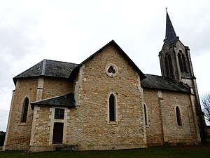
 Brouchaud - Church |
||

Brouchaud ( Occitan Brochau ) is a French commune with 218 inhabitants (as of January 1, 2017) in the Dordogne department in the Nouvelle-Aquitaine region (before 2016 Aquitaine ). It belongs to the Arrondissement Nontron ( Périgueux until 2017 ) and the Isle-Loue-Auvézère canton, which has been in existence since 2015 ( Hautefort until 2015 ). The community consists of the town of the same name and several hamlets (hameaux) and individual farms (fermes) .
Location and climate
The town of Brouchaud is located about 28 km (driving distance) east of Périgueux and about 89 km southwest of Limoges on the Blâme stream at an altitude of about 145 m . The climate is temperate; Rain (approx. 905 mm / year) falls over the year.
Population development
| year | 1800 | 1851 | 1901 | 1954 | 1999 | 2015 |
| Residents | 403 | 528 | 464 | 251 | 178 | 227 |
The population decline in the 20th century is mainly due to the mechanization of agriculture and the abandonment of small farms.
economy
The community is still largely agriculturally oriented, with livestock also playing a significant role. Craftsmen and small service providers have settled in the village itself.
history
It is unclear whether the place existed in the Middle Ages - the remains of an abbey are visible, but the current church dates from the 19th century.
Attractions
- The Saint-Pierre-ès-Liens church , built in the neo-Gothic style in the 19th century, is dedicated to the apostle Peter who was freed from prison by an angel . The nave and apse are made of rubble stones; the corner stones are precisely machined. The west tower is clad with house stones.
- Two mansions ( Manoir de Saint-Just and Manoir de la Gilardie ) from the 17th / 18th centuries Century are privately owned.
- Only after heavy or long-lasting rainfall does the spring of the Blâme (Puits de Bontemps) , located approx. 1 km south of the village, bubble out of a round edging. Speleologists have explored several underground caverns.
- The remains of a megalithic dolmen are located in a forest south of the Prunerède district .
Web links
Individual evidence
