
Lussas-et-Nontronneau
| Lussas-et-Nontronneau | ||
|---|---|---|
|
||
| region | Nouvelle-Aquitaine | |
| Department | Dordogne | |
| Arrondissement | Nontron | |
| Canton | Périgord Vert Nontronnais | |
| Community association | Périgord Nontronnais | |
| Coordinates | 45 ° 30 ′ N , 0 ° 35 ′ E | |
| height | 125-232 m | |
| surface | 22.35 km 2 | |
| Residents | 300 (January 1, 2017) | |
| Population density | 13 inhabitants / km 2 | |
| Post Code | 24300 | |
| INSEE code | 24248 | |
.JPG) Château de Beauvais with pigeon tower |
||

Lussas-et-nontronneau ( Occitan Lučac et Nontroneu ) is a French commune of 300 inhabitants (1 January 2017) of the North department Dordogne in the region Nouvelle-Aquitaine (before 2016 Aquitaine ). It belongs to the Arrondissement of Nontron and the canton of Périgord Vert Nontronnais (until 2015 canton of Nontron ). The responsible community association is the Communauté de communes du Périgord Nontronnais . The inhabitants are called Lutronnais or Lutronnaises .
etymology
The place name Lussas goes back to the Gallo-Roman proper name Lucius or Lucaeus , followed by the suffix -acum (domain of, belonging to). Nontronneau is a diminutive of Nontron .
geography
The municipality of Lussas-et-Nontronneau is located about 7 kilometers west-southwest of Nontron (center of Lussas ).
It is surrounded by the following seven communities:
| Hautefaye | Javerlhac-et-la-Chapelle-Saint-Robert | Saint-Martin-le-Pin |
| Connezac |
.svg)
|
Saint-Martial-de-Valette |
| Rudeau-Ladosse | Mareuil en Périgord (formerly Champeaux-et-la-Chapelle-Pommier ) |
In addition to the two centers of Lussas and Nontronneau , the municipality of Lussas-et- Nontronneau includes the following hamlets, farms, a castle and landmarks:
Bondazeau , Bois de Clarat , Bois de la Rauque , Bois du Prêtre , Bosredon , Buzetière , Château de Beauvais , Chez Bini , Chez Garni , Chez Mauvy , Chez Veyssière , Clarat , Fontroubade , La Croix de Charles , La Saudie , La Tonnelle , La Vieille Vigne, La Cabane , Lamourette , Le Clos , Le Coderc , Le Grand Verger , Le Roc de Montcheuil , Le Sauvage , Les Bellus , Les Borderies , Les Fours , Lombardière , Montament (ruin), Plaisance , Puychissou , Puyfagnoux , Puyvigier , Terre Noire , Vieux Sirieix and Villejalet .
The topographically lowest point of the municipality is at 125 meters above sea level on the Bandiat near Bondazeau in the north, the highest point at 232 meters on a ridge in the east on the border with Saint-Martial-de-Valette. The absolute height difference is 107 meters. Lussas is at 185 meters, Nontronneau at 191 meters above sea level.
Transport links

The district of Lussas can be reached via the D 95, which connects to the D 708 from Nontron to Mareuil . The D 95 then continues in a north-westerly direction to Hautefaye and Mainzac ( Charente ). The D 75 from Nontron in the direction of Angoulême passes in the Bandiattal on the north-east and north edge of the municipality . Several municipal roads branch off from it and lead into the municipality of Lussas-et-Nontronneau. For example, at Villejalet towards Nontronneau , at Lespinasse (municipality of Saint-Martin-le-Pin) towards Clarat , Château de Beauvais and Lussas and at Jommelières (municipality of Javerlhac-et-la-Chapelle-Saint-Robert) to the hamlet of Bondazeau .
Hydrography
The north-eastern and northern part of the municipality is touched by the bandiat and drained in a north-westerly direction. Two small left side streams at Villejalet and Lombardière flow in a northerly direction to the Bandiat, some of which are dammed into ponds. At a source east of Lussas on the municipal border with Saint-Martial-de-Valette, a small stream rises, which flows westwards to the municipality of Connezac and then flows into the Beaussac . To the north of the Château de Beauvais it still has a right branch.
geology

The oldest standing rocks in the municipality of Lussas-et-Nontronneau come from the Lias of the northeast Aquitaine Basin . These flat-lying sediments of the Lower Jurassic (formation l5-9 ) are exposed near Lombardière in a small, left side valley of the Bandiat. Above the Lias then follows chalky Dogger , who builds up the slopes south of the Bandiat. The Dogger consists of Upper Bajocium (Formation J1B-2a ) and Bathonian (Formation J2B ), in the main, cryptocrystalline Oolithkalke . It can also appear recrystallized . North and west of Lussas is still Oxfordian - fine-grained, beige limestone formation J2-6 (b) - survived.
The majority of the municipality is, however, largely veiled by Pleistocene colluvium (clays and fine sands of the AC formation ). North of the Château de Beauvais and south of Le Coderc can be found on the Oxfordian würmzeitliche calcareous talus deposits ( French Grèzes ) caused by Gelifraktion were produced (Tau-freezing cycles) (Formation GP ). At the high point in the southeast near La Saudie , a small occurrence of rock-forming sands and gravel of fluvial origin is also worth mentioning, which are likely to come from the Eocene / Oligocene (formation HF ); they belong to a fossil river system of the Massif Central , which was then rising ; its main branch running in south-south-west direction follows the municipal boundary of Saint-Martial-de-Valette and Saint-Front-sur-Nizonne .
The Bandiat and also the stream that drains to the Beaussac flow in valley floodplains made of Worm Age / Holocene alluvium ( gravel and river sands of the K formation ).
The recrystallized Dogger suggests tectonic processes, which are probably related to the formation of the Bandiat Rift .
ecology

Natural park
The municipality of Lussas-et-Nontronneau has been an integral part of the Périgord-Limousin Regional Nature Park since 1998 .
Protected area
The Bandiat Valley in the north-east and north, which is designated as ZNIEFF (French zone naturelle d'intérêt écologique, faunistique et floristique ) of type 1 under the name Vallées du réseau hydrographique du Bandiat , is under nature protection. The flora includes more than 100 plant species with large ormennig (Agrimonia procera) and Atlantic hare bells (Hyacinthoides non-scripta) as indicator plants.
history
The oldest settlement remains in the municipality go back to the Paleolithic . In 1908, traces from the Upper Mousteria were discovered in the Grotte des Grèzes . Cultural evidence in Lussas-et-Nontronneau is a Gallo-Roman villa complex from the 1st century near Nontronneau , which came to light during the drought of 1967. Several Romanesque buildings date from the Middle Ages , such as the church of Saint-Étienne in Lussas from the 12th century, the church in Nontronneau and the remains of the old chapel in Fontroubade , also from the 12th century. The former Romanesque chapel of Saint-Christophe in Bondazeau has now completely disappeared. The Château de Beauvais was built at the end of the 16th century.
Lussas-et-Nontronneau once consisted of four parishes: Lussas, Fontroubade, Nontronneau and Bondazeau. The previously independent communities Lussas and Nontronneau merged in 1827 to Lussas-et-Nontronneau.
Population development
| Population development in Lussas-et-Nontronneau | ||||
|---|---|---|---|---|
| year | Residents |

|
||
| 1962 | 461 | |||
| 1968 | 364 | |||
| 1975 | 370 | |||
| 1982 | 359 | |||
| 1990 | 363 | |||
| 1999 | 371 | |||
| 2004 | 384 | |||
| 2006 | 376 | |||
| 2007 | 359 | |||
| 2008 | 341 | |||
| 2009 | 323 | |||
| 2013 | 311 | |||
| 2014 | 313 | |||
| 2015 | 312 | |||
| 2016 | 308 | |||
| 2017 | 300 | |||
Source: INSEE
The population of Lussas-et-Nontronneau suffered severe losses during the 1960s, but then stabilized again. It has been falling again since 2006.
With an area of 22.35 square kilometers, the municipality has a very low population density of 13 inhabitants / km².
mayor
Mayor of Lussas-et-Nontronneau has been Ms. Mauricette Belly, who is independent and active in trade, since March 2001.
economy

Economic use
In the municipality of Lussas-et-Nontronneau, agricultural (arable farming, animal husbandry) and forestry (extensive forests) are predominant.
employment
In 2012, 144 employable persons between 15 and 64 years of age were registered in the municipality, which corresponds to 46.4% of the total population. The number of unemployed has increased slightly from 14 to 15 since 2007, making the unemployment rate 10.3%.
Companies
As of December 31, 2013, 25 companies were located in Lussas-et-Nontronneau, 8 of them in agriculture, forestry and fisheries, 7 in trade, transport and services, 4 in construction, 4 in industry and 2 in administration, education and health and social.
Attractions
- The 12th century Romanesque church of Saint-Étienne in Lussas .
- The Romanesque church of Saint-Jean de Nontronneau .
- The ruins of the Romanesque chapel of Sainte-Radegonde in Fontroubade from the 12th century, monument historique since 1988 .
- The Château de Beauvais with pigeon tower , from the 16th century, has been a monument historique since 1973.
The Gallo-Roman villa complex at Nontronneau Villa Rustica is privately owned and was covered with sand again after the end of the research campaigns from 1970 to 1984 and 2002 to 2005 in order to guarantee conservation.
Photo gallery

Romanesque church of Saint-Jean in Nontronneau
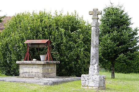
Fountain and stone cross in Nontronneau

Entrance portal of the Romanesque church of Saint-Étienne in Lussas

The Saint-Étienne church in Lussas

Bas-relief with deer from Villa Rustica

Beauvais Castle
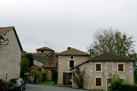
Entrance to Lussas

The hamlet of Le Coderc

Winter floods on the Bandiat north of Bondazeau


.jpg)
literature
- J.-P. Floc'h u. a .: Feuille Nontron . In: Carte géologique de la France à 1/50000 . BRGM.
- G. Le Pochat et al .: Montbron . In: Carte géologique de la France at 1/50 000 . BRGM, 1986.
Web links
- Website with Occitan place names in the Dordogne department
- Lussas-et-Nontronneau on the annuaire-mairie.fr website
- Lussas-et-Nontronneau on cartesfrance.fr in French
- Population development since 1793 on cassini.ehess.fr