
Negroondes
|
Négrondes Negrondes |
||
|---|---|---|

|
|
|
| region | Nouvelle-Aquitaine | |
| Department | Dordogne | |
| Arrondissement | Nontron | |
| Canton | Thiviers | |
| Community association | Périgord-Limousin | |
| Coordinates | 45 ° 21 ′ N , 0 ° 52 ′ E | |
| height | 155-232 m | |
| surface | 20.15 km 2 | |
| Residents | 815 (January 1, 2017) | |
| Population density | 40 inhabitants / km 2 | |
| Post Code | 24460 | |
| INSEE code | 24308 | |
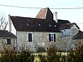
.JPG) View of Négrondes |
||

Négrondes ( Occitan : Negrondes ) is a French municipality with 815 inhabitants (as of January 1 2017) in the north of the department Dordogne in the region Nouvelle-Aquitaine (before 2016: Aquitaine ). The municipality belongs to the arrondissement of Nontron and the canton of Thiviers (until 2015: canton of Savignac-les-Églises ). The inhabitants are called Négrondais .
geography
Négrondes is located about 21 kilometers north-northeast of Périgueux . The Beauronne rises here . Négrondes is surrounded by the neighboring communities of Vaunac in the north, Corgnac-sur-l'Isle in the northeast, Saint-Jory-las-Bloux in the east, Sorges et Ligueux en Périgord in the south, Saint-Front-d'Alemps in the southwest and Lempzours in the West and northwest.
The National Route 21 runs through the municipality .
Population development
| 1962 | 1968 | 1975 | 1982 | 1990 | 1999 | 2006 | 2013 |
|---|---|---|---|---|---|---|---|
| 635 | 603 | 565 | 578 | 664 | 659 | 782 | 833 |
| Source: Cassini and INSEE | |||||||
Attractions
- Saint-Pierre-ès-Liens church from the 19th century
- Schloss Lage, Monument historique since 1987
- Barbary Castle

Saint-Pierre-ès-Liens church
Castle location
.JPG)
.JPG)