Saint-Pierre-de-Frugie
|
Saint-Pierre-de-Frugie Sent Peir de Frègia |
||
|---|---|---|

|
|
|
| region | Nouvelle-Aquitaine | |
| Department | Dordogne | |
| Arrondissement | Nontron | |
| Canton | Thiviers | |
| Community association | Périgord-Limousin | |
| Coordinates | 45 ° 34 ′ N , 1 ° 0 ′ E | |
| height | 305-491 m | |
| surface | 21.74 km 2 | |
| Residents | 398 (January 1, 2017) | |
| Population density | 18 inhabitants / km 2 | |
| Post Code | 24450 | |
| INSEE code | 24486 | |
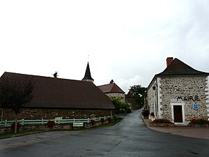
 The center of Saint-Pierre-de-Frugie |
||
Saint-Pierre-de-Frugie ( Occitan Sent Peir de Fregia ) 398 inhabitants (at January 1, 2017) in the northeast of the department Dordogne , Region Nouvelle-Aquitaine . It is an integral part of the Périgord-Limousin Regional Nature Park .
etymology
The name of the community is derived from Saint Peter and the Latin fracto Iove ( broken Jupiter ), probably in reference to a destroyed Jupiter temple .
geography
Saint-Pierre-de-Frugie is 4 kilometers northeast of La Coquille and 9 kilometers south of Châlus (as the crow flies). The municipality is border municipality to the Haute-Vienne department . It is surrounded by the following neighboring communities:
- Bussière-Galant (Haute-Vienne department) to the north and east
- Saint-Priest-les-Fougères to the south
- La Coquille in the southwest
- Firbeix to the west
In addition to the town center, the community consists of the following hamlets, farmsteads, mills and castles: Aillac , Bussin , Château de Frugie , Château de Montcigoux , Château de Vieillecour , Fot , Froidefond , L'Age , La Gare , La Grange , La Lande du Puy , Le Breuilh , Le Mont , Le Moulin de Bussin , Le Moulin du Breuilh , Le Pont de Montcigoux , Le Puy , Les Landes d'Arsac , Les Landes de Vieillecour , Les Poujades , Les Trois Fontaines , Loubatour , Montcigoux , Plagne de Vassoux , Tulle , Vassoux , Verdemille and Vieillecour .
The municipality of Saint-Pierre-de-Frugie is drained roughly in the middle by the Valouse in a southerly direction. The Valouse takes on several smaller right side streams. The Périgord also flows from the massif of Vieillecour ( Forêt de Vieillecour ) in a southerly direction and also forms the southeastern border to the neighboring municipality of Bussière-Galant (district of Saint-Nicolas-de-Courbefy).
The topographical lowest point in the municipality with 305 meters is on the southern border south of Le Breuilh ; here the Valouse leaves the municipality to the south. The highest point at 491 meters is located on the eastern border with Saint-Nicolas-de-Courbefy (Bussière-Galant municipality) in the Forêt de Vieillecour . It is also the highest point in the Dordogne department.
geology
The municipality of Saint-Pierre-de-Frugie is entirely located on the metamorphic basement of the northwestern Massif Central . The surrounding rocks form part of the lower gneiss cover , it is mainly paragneiss , leptynite and leptynitic eye gneiss . These metamorphic rocks from the Sillimanite zone are intruded in the east of the municipal area ( Forêt de Vielfaltcour ) by the Saint-Nicolas-Courbefy granite , a calcareous two-mica granite .
The La Coquille fault crosses the community in a north-easterly direction (N 040 - N 050) - a system of several faults oriented approximately in parallel . Several mineralized quartz veins have formed along this fault zone . The parent rocks were also occasionally converted into cataclasites or mylonites (for example at Le Puy ). The fault zone also penetrates the granite and has cataclazed it in places.
The following mineralizations in the quartz veins are to be cited: galena and zinc blende , as well as antimonite , arsenopyrite , chalcopyrite , covelline and pyrite (at Château de Vieillecour and Le Puy ).
history
The oldest preserved building remains in the commune of Saint-Pierre-de-Frugie can be found at Château de Montcigoux from the 12th century. The Romanesque church in the town center is likely to be about the same age . The Château de Frugie dates back to the 14th and 15th centuries. The Château de Vieillecour dates from the 16th century. The place is listed as Frugie on the Cassini map of 1746 .
Population development
| Population development in Saint-Pierre-de-Frugie | ||||
|---|---|---|---|---|
| year | Residents |

|
||
| 1962 | 679 | |||
| 1968 | 584 | |||
| 1975 | 516 | |||
| 1982 | 487 | |||
| 1990 | 413 | |||
| 1999 | 373 | |||
| 2006 | 403 | |||
| 2016 | 391 | |||
Source: INSEE
The population of Saint-Pierre-de-Frugie fell sharply until 1999, but has since recovered somewhat.
Attractions
- Romanesque church Saint-Pierre et Saint-Paul , heavily modified in the 17th century
- 17th century Château de Montcigoux with remains from the 12th century
- Château de Frugie from the 17th century with ruins from the 14th and 15th centuries, monument historique since 1968
- Château de Vieillecour from the 16th century, monument historique since 1946
- Écocentre in the hamlet of Froidefond , a training center for ecological building
Transport links
The center of Saint-Pierre-de-Frugie is crossed by the D 67 coming from the north; it connects the town of La Gare (Bussière-Galant municipality) with La Coquille. At the western edge of the municipality, the main artery N 21 ( Limoges - Périgueux ) passes in a north-south direction. The municipality is also crossed by the Nexon - La Coquille railway in a south-south-west direction, part of the Limoges - Thiviers - Périgueux line.
Individual evidence
literature
- Briand, B. et al .: Feuille Châlus . In: Carte géologique de la France à 1/50000 . BRGM.
- Dominique Richard (Ed.): Le Guide Dordogne-Périgord. Fanlac, Périgueux 1993, ISBN 2-86577-162-8 .

