
Javerlhac-et-la-Chapelle-Saint-Robert
| Javerlhac-et-la-Chapelle-Saint-Robert | ||
|---|---|---|

|
|
|
| region | Nouvelle-Aquitaine | |
| Department | Dordogne | |
| Arrondissement | Nontron | |
| Canton | Périgord Vert Nontronnais | |
| Community association | Périgord Nontronnais | |
| Coordinates | 45 ° 34 ′ N , 0 ° 34 ′ E | |
| height | 115-211 m | |
| surface | 29.25 km 2 | |
| Residents | 846 (January 1, 2017) | |
| Population density | 29 inhabitants / km 2 | |
| Post Code | 24300 | |
| INSEE code | 24214 | |
 The center of Javerlhac from the west |
||

Javerlhac-et-la-Chapelle-Saint-Robert , Occitan Javerlhac e la Chapela Sent Robert , is a municipality with 846 inhabitants (as of January 1, 2017) in the French department of Dordogne in the Nouvelle-Aquitaine region (before 2016 Aquitaine ). It belongs to the Arrondissement of Nontron and the canton of Périgord Vert Nontronnais (until 2015 canton of Nontron ). The responsible community association is the Communauté de communes du Périgord Nontronnais . The inhabitants are called Javerlhacois or Javerlhacoises .
etymology
The place name of Javerlhac is possibly of Celtic origin and was formerly Jabreille (land of goats). Another theory interprets it as Gallo-Roman , derived from the proper name Gabrelius or Gabrillus and provided with the suffix –acum , which acts as a place or title.
The place name of Chapelle Saint-Robert goes back to a saint named Sanctus Robertus , the Occitan Chapela means chapel.
geography
Javerlhac-et-la-Chapelle-Saint-Robert is 13 kilometers from Nontron and 35 kilometers from Angoulême . The community is surrounded by the following 8 neighboring communities:
| Souffrignac (Charente) | Varaignes , Teyjat | Le Bourdeix |
| Mainzac (Charente) |
.svg)
|
Saint-Martin-le-Pin |
| Hautefaye | Lussas-et-Nontronneau |

With its border with Mainzac and Souffrignac, the municipality already touches the Charente department .
The municipality of Javerlhac-et-la-Chapelle-Saint-Robert includes the following districts, hamlets, homesteads, estates, mills, forges and landmarks: Bois de la Cave , Chantegros , Chez Guilleroux , Chez Joly , Chez la Belle , Chez Marronnet , Font Jean , Forgeneuve , Frugier , Grand Gillou , Javerlhac , Jommelière , Labadias , La Chapelle-Saint-Robert , La Cour , La Fayolle , La Forge , La Grande Métairie , La Meynardie , La Petite Forêt , La Renardière , La Richardière , Le Buisson , Le Fayes , Le Grand Lac , Le Gros Chêne , Le Logis , Le Maine , Le Moulin de chez Bertrand , Le Moulin Vieux , Le Petit Guillou , Les Beusses , Les Boissières , Les Bouèges , Les Brandes , Les Brousses , Les Céceilles , Les Chenauds , Les Essarts , Les Gardechoux , Les Garennes , Les Guétières , Les Petites Chenauds , Les Termes , Maine Chambard , Marronnet , Meynardière , Petit Gillou , Petite Métairie , Pic Pérou , Pierre Virade , Puymoger , Pys , Saute Bouc , Tassat and Ville de Bost .
The topographically lowest point at 115 meters is on the Bandiat near Le Logis on the north-western border with the municipality of Souffrignac, the highest point at 211 meters is in the extreme northeast near Pys . The maximum height difference is 96 meters. The center of Javerlhac is at 128 meters, La Chapelle-Saint-Robert at 168 meters above sea level.
Transport links
Javerlhac is crossed by the D 75 from Nontron to Marthon to the northwest, following the course of the Bandiat , and the D 93 from Étouars to Mainzac crosses in a northeast-southwest direction . La-Chapelle-Saint-Robert can be reached from Javerlhac via the D 92.
Hydrography
.JPG)
The municipality is divided into two parts from the southeast to northwest flowing Bandiat , with a much larger area on the left. About a kilometer before Javerlhac, the Bandiat takes on its right-hand tributary, the Doue , which also forms the municipal boundary with Saint-Martin-le-Pin . The area on the left has no permanent rivers due to karst phenomena , on the right the Marcourive , the Merlançon and the Ruisseau de Saint-Martin should also be mentioned.
geology

The rocks in the municipality belong mainly to the sediments of the Aquitaine Basin , only on the extreme eastern edge of the Doue are cut - due to the erosion work of the river - even deeper Variscan basement rocks of the Massif Central ( Piégut-Pluviers-Granodiorite in coarse-grained normal facies - γ 3M ). The sedimentary rocks come mainly from the Dogger . East of Pys , however, there is still a small gusset with the Lower Jurassic ( Hettangian to Sinemurian cycle - formation l1-4 - and Pliensbachian to Aalenian cycle - formation l5-9 ).
The Doggerserie begins in the Middle Bajocium (Formation J1B - gray Oolithkalke with brown ooids ), followed by Upper Bajocium (Formation J1C - micromolar to crypto-crystalline, white and beige Fossilkalke that several significant Oolithlagen included). These rocks can be very strongly recrystallized and silicified in places (formation jC ). On the left side of the bandiats, bathonium (formations j2a and j2b ) and callovium (formations j1c-3a and j3 ) follow above the Bajocium - also white, beige, and sometimes brownish fossil limestone , which can already be formed like chalk. The Bathonium is about 50 meters thick and contains lithoclasts, bioclasts with remains of lamellibranchers , rhynchonellids and gastropods , as well as relatively rare oolite layers. The 25 meter thick callovium contains oncolites , foraminifera and stromatolites .
The sediments are largely flat, only at Javerlhac local tilts occur in a south-east-north-west trending fault zone ; the north-eastern basement block was raised at it. At Pys , a similar fault zone running over from Nontron runs out in parallel. It is mineralized and contains mainly sphalerite , pyrite , barite and galena . The disturbance is likely to be related to the north-eastern trough shoulder of the Bandiat trench . Smaller faults permeate the sediment package on the left side of the Bandiat in east-northeast and east-south-east directions.
At La-Chapelle-Saint-Robert - like in the neighboring municipality of Souffrignac - some iron ore was mined from the tertiary Sidérolithique , which covered the callovium, and was then smelted at Forgeneuve . In the Eocene / Pliocene period , extensive river systems then moved out of the basement in a south-westerly direction. Their sandy-gravelly deposits (formation HF ) appear on the northeast border towards Chauffour , north of Pys and east of Puymoger , but also on the opposite side of the valley at Les Petites Brousses .
Many of the plateau and slopes are covered by Pleistocene colluvium (formations HC and C ). The formation HC is an Ice Age rearrangement product of the preceding river sediments and is older than the sands, and clays of the formation C .
In the river valley of the Bandiat there are alluvial gravel and pebbles (formation Fv ) in the remains of a high terrace west of the town center . River sands with quartz pebbles (formation Fw ) form a middle Pleistocene central terrace in the valley of the Bandiat (for example at Le Moulin de chez Bertrand ). The modern river has dug itself into the middle terraces and now flows in the Holocene alluvium (formation Fy-z ).
ecology

Natural park
The municipality of Javerlhac-et-la-Chapelle-Saint-Robert has been an integral part of the Périgord-Limousin Regional Nature Park since 1998 .
Protected area
In nature the Bandiattal and the lower reaches of the stand Doue and the Ruisseau de Saint-Martin both right tributaries of Bandiats -. These areas are designated as continental ZNIEFF (French zone naturelle d'intérêt écologique, faunistique et floristique ) of type 1 under the name Vallées du réseau hydrographique du Bandiat . Its flora consists of more than 100 plant species with large ormennig ( Agrimonia procera ) and Atlantic hare bells ( Hyacinthoides non-scripta ) as indicator plants.
history

The settlement of Javerlhac goes back at least to the first century BC, as evidenced by Iron Age finds in the Ormes cave . The ring of a Roman knight and graves from the Gallo-Roman and Merovingian times were found during the construction of the station on the former, but now disused, Pranzac-Quéroy-Thiviers railway .
In the early Middle Ages, cultural life then shifted to Saint-Robert , three kilometers away - a Romanesque church with an entrance portal in Saintong style from the 11th century, which had emerged from a Benedictine priory that had existed since 1050 . The presence of the Benedictines can be traced back to the year 980. The priory was abandoned in the 16th century, the former convent buildings are no longer preserved.
In the 12th century, construction began on the Saint-Étienne church with an asymmetrical double nave in Javerlhac . The adjacent castle originally dates from 1225, but was destroyed by the English in 1369 and rebuilt in 1499.
In the 18th century, under the direction of the Marquis de Montalembert, numerous blacksmiths' works emerged on the Bandiat, including Forgeneuve , Jommelières and the Forge de la Chapelle .
The community Javerlhac-et-la-Chapelle-Saint-Robert was merged in 1823 from the two former communities Javerlhac and La-Chapelle-Saint-Robert .
Population development
| Population development in Javerlhac-et-la-Chapelle-Saint-Robert | ||||
|---|---|---|---|---|
| year | Residents |

|
||
| 1962 | 1175 | |||
| 1968 | 1129 | |||
| 1975 | 1071 | |||
| 1982 | 1004 | |||
| 1990 | 1064 | |||
| 1999 | 915 | |||
| 2004 | 895 | |||
| 2006 | 897 | |||
| 2008 | 901 | |||
| 2009 | 903 | |||
| 2013 | 876 | |||
| 2014 | 860 | |||
| 2015 | 858 | |||
| 2016 | 852 | |||
| 2017 | 846 | |||
Source: INSEE
The population development has generally declined since 1962, but it had recovered somewhat before 1990.
mayor
Mayor of Javerlhac-et-la-Chapelle-Saint-Robert has been Jean-Pierre Porte , a member of Divers droite , since March 2014 .
Economy
employment
In 2011 the number of employable persons between 15 and 64 years of age was 407, i.e. H. 45.6% of the total population. The number of unemployed has increased from 37 in 2007 to 48, which now corresponds to an unemployment rate of 11.8%.
Companies
As of December 31, 2013, 95 companies were located in the municipality, of which 44 in the trade, transport and services sector, 15 in agriculture, forestry and fishing, 15 in construction, 14 in industry and 7 in the administration, education, health and social sectors.
Attractions
- The 11th century Romanesque church of Saint-Robert in La-Chapelle-Saint-Robert, recognized as a monument historique since 1920 .
- The church of Saint-Étienne in Javerlhac from the 12th and 16th centuries, designated as a monument historique since 1948.
- The 16th century Château de Javerlhac , a historic monument since 1974. With pigeon tower and water mill for the production of walnut oil.
- The 17th century Château de Puymoger
- Manoir du Logis
- The royal forge at Forgeneuve with a large mill wheel and blast furnace . Cannons for the navy were once cast here. Monument historique since 1976.
Photo gallery
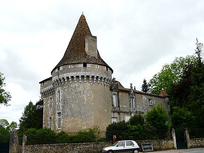 Javerlhac Castle
 The Manoir du Logis
 The Forgeneuve mill wheel
 The tower of the
Saint-Étienne church Niche with two gisants in Saint-Étienne
 Capitals at the entrance of
Saint-Robert Javerlhac town center with town hall, post office and ballroom


.JPG)


.JPG)

Individual evidence
- ^ Occitan name of the parishes in Périgord, website of the Conseil général de la Dordogne
- ↑ Javerlhac-et-la-Chapelle-Saint-Robert on the Insee website
- ^ Church of La-Chapelle-Saint-Robert in the Mérimée database of the French Ministry of Culture
- ^ Church of Javerlhac in the Mérimée database of the French Ministry of Culture
- ↑ Javerlhac Castle, Mérimée database of the French Ministry of Culture
- ^ Forgeneuve, Mérimée database of the French Ministry of Culture
swell
- G. Le Pochat and others: Feuille Montbron . In: Carte géologique de la France at 1/50 000 . BRGM, 1986.
Web links
- Information on Javerlhac-et-la-Chapelle-Saint-Robert
- History of Javerlhac-et-la-Chapelle-Saint-Robert
- Website with Occitan place names in the Dordogne department
- Javerlhac-et-la-Chapelle-Saint-Robert on the annuaire-mairie.fr website
- Javerlhac-et-la-Chapelle-Saint-Robert on cartesfrance.fr in French
- Population development since 1793 on cassini.ehess.fr