
Mainzac
|
Mainzac Minzac |
||
|---|---|---|
|
||
| region | Nouvelle-Aquitaine | |
| Department | Charente | |
| Arrondissement | Angoulême | |
| Canton | Val de Tardoire | |
| Community association | La Rochefoucauld-Porte du Périgord | |
| Coordinates | 45 ° 33 ' N , 0 ° 29' E | |
| height | 119-192 m | |
| surface | 11.29 km 2 | |
| Residents | 110 (January 1, 2017) | |
| Population density | 10 inhabitants / km 2 | |
| Post Code | 16380 | |
| INSEE code | 16203 | |
| Website | http://www.mainzac16.com/ | |
 Town hall (Mairie) of Mainzac |
||

Mainzac ( Occitan : Minzac ) is a French municipality with 110 inhabitants (as of January 1 2017) in the department of Charente in the region Nouvelle-Aquitaine . It belongs to the canton of Val de Tardoire (until 2015 canton of Montbron ). The responsible community association is the Communauté de communes La Rochefoucauld-Porte du Périgord . The inhabitants are called Mainzacois or Mainzacoises .
etymology
The origin of Mainzac can be traced back to the Gallo-Roman personal name Mintius or Magentius . If the suffix -acum is added to indicate possession, the result is Mintiacum / Magentiacum or the domain of Mintius / Magentius .
location
The municipality of Mainzac is located about 27 kilometers east-southeast of Angoulême and 14 kilometers west of Nontron . After Montbron in the north is 13 kilometers to Marthon in northwestern seven kilometers, according to Villebois-Lavalette in the southwest and 18 km of Périgueux 45 km. It is a border municipality to the Dordogne department . Mainzac is surrounded by the following six neighboring communities:
| Feuillade | Feuillade, Souffrignac | Javerlhac-et-la-Chapelle-Saint-Robert (Dordogne) |
| Charras |
.svg)
|
Javerlhac-et-la-Chapelle-Saint-Robert, Hautefaye |
| Charras | Mareuil en Périgord (formerly Beaussac - Dordogne) | Hautefaye (Dordogne) |
The highest topographic point at 192 meters is a ridge east of the town center, the lowest point at 119 meters is in the extreme northwest at Le Maine au Clair . The absolute height difference is 73 meters.
In addition to the center of Mainzac, the community consists of the following hamlets, farmsteads, a castle and landmarks: Bois du Lac, Chevalerias, Chez Bomby, Faurias, Ferdinas, La Breuille, La Chabrie, La Combe, La Ferrière, La Grande Metairie, La Jaumerie , La Voûte, Labadias, Le Breuil, Le Brouillas, Le Maine au Clair, Le Rocher, Les Breuilles, Les Fouilloux, Les Pradeaux, Les Rocs, Puymasson and Remondias .
Transport links

Mainzac is a little away from major traffic arteries. The D 4 (D 75 in the Dordogne) runs from Angoulême to Nontron via Marthon and Javerlhac 5 kilometers further north and the D 16 from Montmoreau-Saint-Cybard to Confolens via Villebois and Montbron 6 kilometers further northwest. The D 93 from La-Chapelle-Saint-Robert to Charras, the D 65 from Souffrignac to Hautefaye and the D 111 coming from Marthon meet in the town center.
Hydrography
The municipality Mainzac is on a south of the Bandiats located karstic limestone plateau and therefore has had no water courses. The town center is in the immediate vicinity of a dry valley moving northwest . Another dry valley also runs on the west side of the municipality. This begins at Puymasson , pulls north and then turns to the northwest at the lowest point. Both valley systems end blindly and are cut a good 20 meters into the plateau area.
geology
The plateau, which lies at an average height of 160 meters, is made up of flat limestone sediments from the northeastern Aquitaine Basin . The Central Jurassic strata consists of bathonium (formation j1c-3a ) and callovium (formation j3 ). The approximately 20 meter thick bathonium consists of white to beige, cryptocrystalline fossil limestone, some of which are rich in bioclasts, and which occur in four different sequences. The 25 meter thick callovium shows a chalky character and occurs in two sequences. Present are Trocholinen ( foraminifera ) Pelletoide, Onkolithen and stromatolites . Occasional lithoclasts up to 10 centimeters in size are worth mentioning .
The stratified bond is only slightly disturbed - two small north- northeast trending faults southwest of Remondias have been mapped out .
At the heights around the Bois du Lac and around Puymasson, Faurias and Le Maine au Clair , the limestone sediments are covered by Pleistocene colluvium (formation AC ). The two dry valleys ( also called combes in French ) are filled with Holocene alluvium of the Fy-z formation - brick-red clays and fine sands mixed with pebbles of quartz, quartzite and limestone.
At Mainzac - as in the neighboring communities of Souffrignac and Javerlhac-La-Chapelle-Saint-Robert - some iron was picked up that came from the tertiary Sidérolithique , which covered the callovium, and was then processed in forges in the Bandiattal between Feuillade and Javerlhac. Part of the ore also went to Ruelle-sur-Touvre at times .
history

Mainzac was officially known as Minziaco in 1272 and was then called Minzac, Minzaco and Minzacum in the 14th century . Occitan spoken in the community has retained the form Minzac .
The oldest architectural evidence in the municipality is the crypt in the Romanesque local church of Saint-Maurice from the 10th century . The church itself dates from the 12th century . Next to the church was an old castle, of which only a few remains have survived. Its owners can be traced back to the 12th century. This old manor once belonged to the diocese of Angoulême . The Remo Dias Castle was another mansion, which also was under the diocese of Angoulême. It can be dated to at least the 15th century.
Population development
| Population development in Mainzac | ||||
|---|---|---|---|---|
| year | Residents |

|
||
| 1962 | 177 | |||
| 1968 | 157 | |||
| 1975 | 121 | |||
| 1982 | 110 | |||
| 1990 | 121 | |||
| 1999 | 102 | |||
| 2006 | 110 | |||
| 2007 | 111 | |||
| 2012 | 96 | |||
| 2013 | 95 | |||
| 2016 | 104 | |||
| 2017 | 110 | |||
Source: INSEE
The population development declined until 1982 and has since stabilized with fluctuations.
The population density is very low with an area of 11.29 square kilometers with 10 inhabitants / km².
Mainzac has the lowest population and population density in the canton of Val de Tardoire.
mayor
Mayor of Mainzac has been the non-party teacher Patrice Dominici since 2001.
Attractions
- Church Saint-Maurice from the 12th century crypt of the 10th century
- Castle of Remondias from the 15th century
literature
- J.-P. Floc'h u. a .: Feuille Nontron . In: Carte géologique de la France à 1/50000 . BRGM.
- G. Le Pochat et al .: Montbron . In: Carte géologique de la France at 1/50 000 . BRGM, 1986.
Photo gallery

Crypt under Saint-Maurice

Church interior of Saint-Maurice
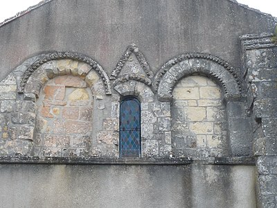
Detail view of the west facade

Walnut plantation


Web links
- Mainzac on the website of annuaire-mairie.fr
- Mainzac on cartesfrance.fr in French
- Population development since 1793 on cassini.ehess.fr