Sers (Charente)
| Sers | ||
|---|---|---|
|
|
||
| region | Nouvelle-Aquitaine | |
| Department | Charente | |
| Arrondissement | Angoulême | |
| Canton | Boëme-Échelle | |
| Community association | Grand Angoulême | |
| Coordinates | 45 ° 36 ′ N , 0 ° 19 ′ E | |
| height | 82-220 m | |
| surface | 14.17 km 2 | |
| Residents | 871 (January 1, 2017) | |
| Population density | 61 inhabitants / km 2 | |
| Post Code | 16410 | |
| INSEE code | 16368 | |
 Sers - Église Saint-Pierre |
||
Sers is a municipality with 871 inhabitants (at January 1, 2017) in western France Charente in the region Nouvelle-Aquitaine .
location
The municipality of Sers is located at an altitude of about 160 meters above sea level. d. M. about 20 kilometers (driving distance) southeast of Angoulême in the old cultural landscape of the Angoumois in the south of the Charente .
Population development
| year | 1962 | 1968 | 1975 | 1982 | 1990 | 1999 | 2006 | 2016 |
| Residents | 408 | 413 | 472 | 540 | 633 | 673 | 710 | 862 |
In the first half of the 19th century, the community usually had between 600 and 750 inhabitants. As a result of the phylloxera crisis in viticulture and the mechanization of agriculture , the number of inhabitants then fell continuously to the lows of the 1920s to 1970s. Due to the proximity to Angoulême and the significantly lower property prices in the countryside, there has been a significant increase in the population over the past few decades.
economy
For centuries, the inhabitants of the community lived on the principles of self-sufficiency from agriculture, only the city of Angoulême came into question as a marketplace. In 1514, a foundry and iron smelter were built in the hamlet of Planche Meunier , which was in operation until 1762. The soils of the municipality still belong to the Bons Bois of the Cognac wine-growing region , but sales of expensive brandies and even wine have tended to decline in recent decades, so that viticulture no longer plays a role today.
history
In 1927, several stones from the Solutréen era, carved with animal figures, were discovered in a rock grotto , which are now in the Musée d'archéologie nationale in Saint-Germain-en-Laye . There is also an already badly damaged dolmen ( Le Roc qui danse ) on the territory of the municipality. Some historians identify Sers with the place Sarum noted on the Peutinger tablets , but the place is located several kilometers from the Roman road between Saintes ( Mediolanum Santonum ) and Périgueux ( Vesunna ). The place names Sersia and Cers have been handed down from medieval times .
Attractions
- The elongated Romanesque parish church of Saint-Pierre dates from the end of the 12th century. The outer walls of the apse , which is covered with stone slabs ( lauzes ), are completely unstructured and unadorned. The four-storey crossing tower of the church is one of the most beautiful and imposing in the Charente : The lower area is unadorned and only accompanied by a square or polygonally broken stair tower ; above is a storey level with blind arcades ; the two upper bell storeys have almost identical sound openings. While the unadorned west facade looks almost like a fortress, on the south side of the church there is an unprofiled archivolt portal with set monolithic columns and an overhanging arch in the form of a diamond rod ; the capitals are adorned , but the combat zone is adorned with a frieze of blocks all around . The nave is 27.60 meters long and 7.25 meters wide and barrel vaulted . The church was recognized as a monument historique in 1970 .
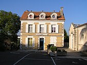
- The former rectory ( presbytère ) dates from around 1800 and is now used as a post office. It was recognized as a Monument historique in 1941 .
- The Ermitage de Bellevau, partially carved into a rock forest, is located in a wood just a few meters above a spring that is revered as a miraculous spring.
- The rock overhang ( Roc de Sers ) with prehistoric animal sculptures (today copies) is located in a forest plot ( 45 ° 34 ′ 29 ″ N , 0 ° 19 ′ 45 ″ E ) about two kilometers south of the village. Besides the rock reliefs on the Chaire de Calvin in Mouthiers-sur-Boëme , it is the only artistic testimony to the presence of prehistoric people in southern Charente.
- The privately owned Logis de Nanteuil ( 45 ° 35 ′ 40 ″ N , 0 ° 18 ′ 13 ″ E ) dates from the 15th century. The renaissance building dispenses with medieval towers, but still has a circular parapet with cantilevered machikoulis above the facade. Inside is a vaulted hall 27 meters long and 6.25 meters wide. The palace construction has been recognized as a monument historique since 1997 .
- Outside the village is the former cannon foundry from 1572 with the associated stately buildings from the 18th century. The building complex has been recognized as a monument historique since 1991 .
Web links
Individual evidence
- ↑ Église Saint-Pierre, Sers in the Base Mérimée of the French Ministry of Culture (French)
- ↑ Ancien Presbytère, Sers in the Base Mérimée of the French Ministry of Culture (French)
- ↑ PA16000009 Logis de Nanteuil, Sers in the Base Mérimée of the French Ministry of Culture (French)
- ^ Haut fourneau, Minoterie, Sers in the Base Mérimée of the French Ministry of Culture (French)


