Chadurie
| Chadurie | ||
|---|---|---|
|
|
||
| region | Nouvelle-Aquitaine | |
| Department | Charente | |
| Arrondissement | Angoulême | |
| Canton | Tude-et-Lavalette | |
| Community association | Lavalette Tude Dronne | |
| Coordinates | 45 ° 30 ′ N , 0 ° 8 ′ W | |
| height | 78-201 m | |
| surface | 16.42 km 2 | |
| Residents | 508 (January 1, 2017) | |
| Population density | 31 inhabitants / km 2 | |
| Post Code | 16250 | |
| INSEE code | 16072 | |
 View of town with Saint-Saturnin church |
||
Chadurie is a western French community with 508 inhabitants (at January 1, 2017) in the department of Charente in the region Nouvelle-Aquitaine .
location
Chadurie is about 21 kilometers (driving distance) south of Angoulême in the cultural landscape of the Angoumois at an altitude of about 90 meters above sea level. d. The rivers Boëme and Arce have their source in the south of the municipality.
Population development
| year | 1962 | 1968 | 1975 | 1982 | 1990 | 1999 | 2006 | 2016 |
| Residents | 517 | 449 | 408 | 417 | 474 | 484 | 512 | 508 |
In the first half of the 19th century the community always had between 750 and 900 inhabitants; As a result of the phylloxera crisis in viticulture and the mechanization of agriculture , the number of inhabitants then fell continuously to the lows in the 1960s and 1970s.
economy
For centuries, the inhabitants of the community lived from agriculture; the soils of the municipality belong to the fins bois of the Cognac wine-growing region , but sales of expensive brandies have tended to decline in recent decades, so that viticulture no longer plays an important role today. Tourism in the form of rental of holiday homes has contributed to the municipality's income since the 1960s.
history
Chadurie is on the Chemin Boisné , an old Roman road that linked Saintes ( Mediolanum Santonum ) and Périgueux ( Vesunna ). Traces of an ancient settlement have been discovered near the hamlet of La Berche . The existence of a medieval place called Cadureia (1030 and 1044) or Catureia (1110) is documented.
Attractions
- The unadorned and undivided Romanesque apse and the crossing tower of the parish church of Saint-Saturnin , which was built around the same time, could still date from the late 11th century; the west facade with its triumphal arch scheme in the portal zone and the three blind arches in the plain above is clearly the work of the 12th century. In the 15th or 16th century, the facade and outer walls of the church were stabilized by mighty buttresses because of the clearly discernible drifting apart of the outer walls in the single-nave interior as a result of the arching . The church has been recognized as a monument historique since 1925 .
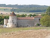
- The Logis de Puygâty , which has been partially converted into a stylish hotel, is located in a valley basin in the south of the municipality ( 45 ° 30 ′ 35 ″ N , 0 ° 8 ′ 43 ″ E ) . The late medieval building with its round corner towers and almost windowless outer walls was redesigned in the 17th century and has been recognized as a monument historique since 1987 .
- The Logis des Thibaudières is a 17th century building in the late Renaissance style; today it serves as a retirement home.
Personalities
- François Faure (1612–1687) was Bishop of Amiens
Web links
- Chadurie, history and sights - photos + brief information (French)
- Chadurie, Logis de Puygâty - Photos + information (French)
- Chadurie - photo
Individual evidence
- ↑ Église Saint-Saturnin, Chadurie in the Base Mérimée of the French Ministry of Culture (French)
- ↑ Logis de Puygâty, Chadurie in the Base Mérimée of the French Ministry of Culture (French)


