
Saint-Saturnin (Charente)
| Saint-Saturnin | ||
|---|---|---|
|
||
| region | Nouvelle-Aquitaine | |
| Department | Charente | |
| Arrondissement | Angoulême | |
| Canton | Val de Nouère | |
| Community association | Grand Angoulême | |
| Coordinates | 45 ° 40 ′ N , 0 ° 3 ′ E | |
| height | 32-114 m | |
| surface | 13.38 km 2 | |
| Residents | 1,292 (January 1, 2017) | |
| Population density | 97 inhabitants / km 2 | |
| Post Code | 16290 | |
| INSEE code | 16348 | |
| Website | http://www.saint-saturnin16.fr/ | |
 Town hall (Mairie) of Saint-Saturnin |
||

Saint-Saturnin is a western French community with 1,292 inhabitants (as of January 1 2017) in the department of Charente in the region Nouvelle-Aquitaine . The municipality belongs to the Arrondissement of Angoulême and the canton of Val de Nouère (until 2015: canton of Hiersac ). The inhabitants are called Saturnina .
location
Saint-Saturnin is located about eight kilometers west of Angoulême in the cultural landscape of the Angoumois . The river Nouère limits the municipality to the east. Saint-Saturnin is surrounded by the neighboring communities Asnières-sur-Nouère in the north, Fléac in the east, Linars in the south-east, Trois-Palis in the south, Champmillon in the west and south-west and Hiersac in the west and north-west.
Population development
| year | 1962 | 1968 | 1975 | 1982 | 1990 | 1999 | 2006 | 2017 |
| Residents | 605 | 619 | 651 | 820 | 1083 | 1159 | 1291 | 1292 |
| Sources: Cassini and INSEE | ||||||||
Attractions
- Saint-Saturnin church from the 12th century
- Maillou Castle from the 16th / 17th centuries century
- House Moulède, former priory

Saint-Saturnin Church
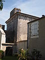
Maillou Castle


Personalities
- Pierre Mathieu-Bodet (1816–1911), politician, French finance minister (1874/75)