Yviers
| Yviers | ||
|---|---|---|
|
|
||
| region | Nouvelle-Aquitaine | |
| Department | Charente | |
| Arrondissement | Angoulême | |
| Canton | Tude-et-Lavalette | |
| Community association | Lavalette Tude Dronne | |
| Coordinates | 45 ° 17 ′ N , 0 ° 0 ′ W | |
| height | 48-147 m | |
| surface | 22.56 km 2 | |
| Residents | 510 (January 1, 2017) | |
| Population density | 23 inhabitants / km 2 | |
| Post Code | 16210 | |
| INSEE code | 16424 | |
 Mairie Yviers |
||
Yviers is a French municipality with 510 inhabitants (as of January 1 2017) in the department of Charente in the region Nouvelle-Aquitaine . The municipality belongs to the Arrondissement of Angoulême and to the municipality association Lavalette Tude Dronne, founded in 2017 .
geography
The municipality of Yviers is located in the south of the historical province of Angoumois in the wooded south of the Charente department on the border with the Charente-Maritime department , about 45 kilometers south of Angoulême . The Argentonne , a right tributary of the Tude, flows through the gently sloping terrain of the municipality to the southwest . With 22.56 km², Yviers is one of the larger municipalities in the department. In addition to the eponymous Yviers, the municipality includes the villages of Les Gorces, Chet Foucher, Chez Touray, Les Foucaudes, Chez Rassat, Le Portail Bleu, La Lime, Chez Parlant and Le Moulin de la Motte as well as part of the villages of Chez Tureau and Chez Lavaud . Yviers is surrounded by the neighboring communities of Bardenac in the north, Curac in the northeast, Chalais in the east, Rioux-Martin in the south, La Genétouze in the southwest, Sauvignac in the west and Saint-Vallier in the northwest.
Population development
| year | 1962 | 1968 | 1975 | 1982 | 1990 | 1999 | 2005 | 2016 | |
| Residents | 493 | 428 | 415 | 516 | 503 | 468 | 487 | 511 | |
| Sources: Cassini and INSEE | |||||||||
Attractions
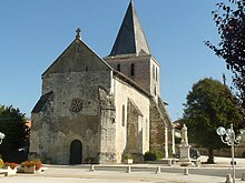
The parish church of Notre-Dame is Romanesque in origin from the 12th century. Only the northern wall has survived from this period. The church was rebuilt in the 14th century, but it has retained its monumental appearance. The portal was decorated with fine Renaissance sculptures.
The tower of Yviers is an imposing residence of the former house of Talleyrand-Périgord , later also Bertrand de La Tour (approx. 1330-1382), bishop of Toul, then bishop of Puy-en-Velay resided here . The tower was restored in the 16th century.
Economy and Infrastructure
No wines are currently produced in Tieste-Uragnoux, but the sites would be approved for the use of the Côtes de Saint-Mont label .
There are 27 farms in the community (growing grain, raising cattle, goats and sheep), including two winegrowers. The few Rebhämge are on the extreme southeastern edge of the wine-growing region of Cognac and belong to the Bons Bois .
The D 674 trunk road runs from Angoulême to Libourne three kilometers east of Yviers . In the community of Chevanceaux , 20 kilometers to the west, there is a connection to the motorway-like RN 10 from Angoulême to Bordeaux . The nearest train station is in the eastern neighboring municipality of Chalais on the Paris – Bordeaux line .

