
Laprade (Charente)
| Laprade | ||
|---|---|---|
|
||
| region | Nouvelle-Aquitaine | |
| Department | Charente | |
| Arrondissement | Angoulême | |
| Canton | Tude-et-Lavalette | |
| Community association | Lavalette Tude Dronne | |
| Coordinates | 45 ° 17 ′ N , 0 ° 11 ′ E | |
| height | 40-132 m | |
| surface | 10.17 km 2 | |
| Residents | 247 (January 1, 2017) | |
| Population density | 24 inhabitants / km 2 | |
| Post Code | 16390 | |
| INSEE code | 16180 | |
 Laprade Town Hall ( Mairie ) |
||

Laprade is a French municipality with 247 inhabitants (as of January 1 2017) in the department of Charente in the region Nouvelle-Aquitaine . The municipality belongs to the arrondissement Angoulême , the canton Tude-et-Lavalette and the municipality association Lavalette Tude Dronne, founded in 2017 . The inhabitants are called Lapradia .
geography
Laprade is located in the south of the historical province of Angoumois , about 55 kilometers south-southwest of Angoulême on the Dronne . Laprade is surrounded by the neighboring communities of Pillac in the north, Nabinaud in the east and northeast, Petit-Bersac in the east and southeast, Saint Privat en Périgord in the south, Aubeterre-sur-Dronne in the southwest and Saint-Romain in the west.
Population development
| year | 1962 | 1968 | 1975 | 1982 | 1990 | 1999 | 2006 | 2013 |
| Residents | 353 | 316 | 265 | 223 | 207 | 209 | 223 | 235 |
| Source: Cassini and INSEE | ||||||||
Attractions
- Church of Sainte-Anne
- Le Janvray Castle, built between 1895 and 1900
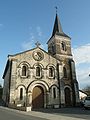
Church of Sainte-Anne

Le Janvray Castle

