Écuras
|
Écuras Escuras |
||
|---|---|---|
|
|
||
| region | Nouvelle-Aquitaine | |
| Department | Charente | |
| Arrondissement | Angoulême | |
| Canton | Val de Tardoire | |
| Community association | La Rochefoucauld-Porte du Périgord | |
| Coordinates | 45 ° 41 ′ N , 0 ° 34 ′ E | |
| height | 111-280 m | |
| surface | 24.22 km 2 | |
| Residents | 582 (January 1, 2017) | |
| Population density | 24 inhabitants / km 2 | |
| Post Code | 16220 | |
| INSEE code | 16124 | |
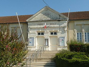
 Town hall (Mairie) of Écuras |
||
Écuras ( Occitan : escuras ) is a town and several places with 582 inhabitants (as of January 1 2017) in the western French department of Charente in the region Nouvelle-Aquitaine . It belongs to the Arrondissement of Angoulême and the canton of Val de Tardoire ( canton of Montbron until 2015 ). The responsible community association is the Communauté de communes La Rochefoucauld-Porte du Périgord . The inhabitants are called Écurassiens or Écurassiennes .
etymology
It is believed that the place name Écuras is based on a Gallo-Roman Scurrius . Together with the suffix -acum results in Scurriacum - the estate of Scurrius . Another attempt at interpretation is based on the Germanic skur (barn, barn, stable), from which the Occitan escura , French écurie , of equal importance , emerged. The place name occurs quite often - one Escuras can be found in the Dordogne, five Écures in the Charente, but also Hautes Écures and Le Moulin des Écures . The hamlet of Châtain-Besson means twin chestnuts ( in Occitan, besson denotes a pair of twins).
location
Écuras is a municipality on the border with the Dordogne department and is located about 35 kilometers east of the prefecture town of Angoulême . After Montbron in the west-southwest is 6, according MONTEMBOEUF the north 15 to Saint-Mathieu in the East also 15, after Nontron in the south 19 to Confolens in the north-northeast and 38 to Limoges in the east-northeast 56 km.
Écuras is surrounded by six neighboring communities:
| Rouzède | Roussines | |
| Montbron |

|
Busserolles (Dordogne) |
| Eymouthiers , Bussière-Badil (Dordogne) | Bussière-Badil (Dordogne) |
The municipality includes the following districts, hamlets, farms, brickworks, mills and landmarks: Chassagne, Châtain-Besson, Chez Bonnet, Chez Cambrai, Chez Mathias, Coutellerie, Écuras, Empeyrat, Fontaubière, Germanas, L'Etanchon, La Borderie, La Font , La Montecaille, La Prèze, La Tuilerie, Le Bois de la Font, Le Chat, Le Maine Pachou, Le Moulin de Planchas, Le Moulin de Vergnas, Le Moulin du Maine Pachou, Le Triangle, Le Vallon, Les Boins, Les Brugeaux , Les Defaix, Les Forêts, Les Giligies, Les Limousines, Les Mines, Les Perrières, Les Pies, Perry, Puy d'Écuras, Puy de Chat, Rairie and Tuilerie de Rairie . Some districts are quite important, such as Châtain-Besson , where the community's ballroom is located. Le Chat is a Dutch holiday colony.
The topographically lowest point of the municipality with 111 meters above sea level is on the Tardoire in the west near Perry , the highest point with 280 meters above sea level is near La Prèze in the northeast. The maximum height difference is 169 meters. Écuras itself is at 222 meters and Châtain-Besson at 234 meters above sea level.
Transport links
The main traffic axis in the municipality of Écuras is the north-east running D 699 from Montbron to Saint-Mathieu . It overcomes the incised valley of the Tardoire in several loops, enters the Dordogne for 3 kilometers (municipality of Busserolles) and then changes to the department of Haute-Vienne (municipality of Maisonnais-sur-Tardoire ).
Other departmental roads that cross the municipality are the D 112, D 163 and D 416. The D 112 (D 3 in the Dordogne) comes from Bussière-Badil in the south, runs through the town center and continues north towards Rouzède and Le Lindois . The D 163 connects Eymouthiers with Écuras and further with Roussines and Massignac . The D 416 is a cross connection from Rouzède to Roussines, which only touches the northern edge of the municipality.
Through the valley of Renaudie once led railway line of the Chemins de fer économiques des Charentes , the Angoulême Montbron and Roumazières-Loubert linked. The narrow-gauge railway (gauge 1000 mm) began its ascent here on the 353 meter high Massif de l'Arbre .
Long-distance hiking trails
The GR 4 long-distance hiking trail runs through the Tardoire Valley from Royan to Limoges and on to Cannes / Grasse . Between Perry and Le Moulin du Pachou , it touches the south-western edge of the municipality. The south-western part of the commune is also crossed by the GR de Pays Entre Angoumois et Périgord (hiking trail that connects the Angoumois with the Périgord ). Coming from Eymouthiers, it goes through Châtain-Besson in the direction of Rouzède.
Hydrography
Determining the hydrography of the municipality is the Tardoire flowing westwards, which forms the municipality boundary in the southeast and southwest. It has cut more than 100 meters deep into the crystalline basement and meanders in its valley, making a significant change in direction from southwest to northwest at Empeyrat . Also of importance is the Renaudie , a right, 9 km long tributary of the Tardoire. The Renaudie flowing to the southwest marks the northwest border of the municipality. Four smaller dry valleys run parallel to the Renaudie , which also open into the Tardoire on the right.
geology
The municipality of Écuras is predominantly underlain by metamorphic variscuses of the northwestern Massif Central , primarily by gneiss and the leukogranites derived from them . The gneisses are designed as migmatitic paragneiss , which belong to the parautochthonous Saint-Mathieu-Dom . Their age is very likely Ediacarian or Cambrian . The paragneiss has reached the field of anatexis and secreted leucogranitic melts, the degree of anatexis increasing towards the northwest. This continuum begins with the secretion of leucogranitic lenses, continues through hectometric leukogranite ranges (as Champniers-et-Reilhac-leukogranite and its coplanar facies) and goes up to the appearance of Roussines-leukogranite - all special facies of Saint-Mathieu-Leukogranits . The Roussines leuco granite is exposed in the Renaudie valley and is likely to be related to the Mylonitic Montbron Fault (also Le Lindois Fault ) - a significant shear zone in the basement.
The strike direction of the migmatitic paragneiss is generally northeast, but can also turn to north-northeast or east-northeast. They dip between 30 and 65 degrees to the northwest. Corridors or trains of microgranites , leukogranites, lamprophyren and graphite-rich slates are concordantly switched on in many places . However, some microgranite and lamprophyte veins can also penetrate the foliation , such as the large lamprophyre vein near Villautrange on the Tardoire, which strikes south-east.
The basement is selectively transgressed by sediments from the northeastern Aquitaine Basin (for example at Châtain-Besson , La Borderie , Perry and Tuilerie de Rairie ). This is to lower Jurassic - Hettangian ( arkose and dolomite ), detrital Pliensbachian and Toarcian ( claystone and marl ).
Basement and sediments are also covered by the continental Tertiary and Pleistocene colluvium - such as the plateau around Châtain-Besson and la Borderie . The valleys of the Tardoire are filled with Holocene alluvium .
At the end of the 18th century, silver-bearing galena and pyrite were mined in a quartz barite vein between Chassagne and Perry .
ecology
The Renaudie Valley is a protected nature reserve under the name Réserve naturelle régionale de la Vallée de la Renaudie . It also falls under Natura 2000 as Val de Tardoire .
history
In La Borderie and Conan were Roman tegulae discovered - which possibly indicates the presence of Gallo-Roman villas.
In 1281 Écuras is mentioned as Escuras or Escuriis . This changed to Escurato in the 13th century .
languages
The municipality of Écuras belongs to the Occitan-speaking ( Limousin ) eastern section of the Charente.
Population development
| Population development in Écuras | ||
|---|---|---|
| year | Residents |

|
| 1962 | 838 | |
| 1968 | 776 | |
| 1975 | 686 | |
| 1982 | 634 | |
| 1990 | 628 | |
| 1999 | 557 | |
| 2004 | 626 | |
| 2006 | 650 | |
| 2009 | 632 | |
| 2013 | 598 | |
| 2014 | 589 | |
| 2017 | 582 | |
Source: INSEE
The population development in Écuras is generally declining, but had a slight upturn between 1999 and 2006.
With an area of 24.22 square kilometers, the population density is 24 inhabitants / km².
mayor
The mayor of the municipality of Écuras has been the builder Denis Donnary since March 2014.
Attractions
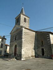
- Saint-Etienne church in Écuras
- Gaillard brickworks from the beginning of the 20th century in Rairie
- Dutch holiday village Le Chat
- La Prèze golf course on the border with Rouzède


