
Massif de l'Arbre
| Massif de l'Arbre | ||
|---|---|---|
 View from the Massif de l'Arbre to the southeast towards Orgedeuil |
||
| Highest peak | l'Arbre ( 353 m ) | |
| location | Charente department (Central France ) | |
| part of | Massif Central | |
|
||
| Coordinates | 45 ° 44 ′ N , 0 ° 32 ′ E | |
| rock | Slate, sediments | |
| surface | 200 km² | |

The Massif de l'Arbre is the western branch of the Monts du Limousin in the Charente department in the Nouvelle-Aquitaine region , France . The crystalline Massif Central ends in it and disappears under the sediments of the Aquitaine Basin .
geography
The Massif de l'Arbre is located around 30 kilometers east of Angoulême , a good 10 kilometers east of La Rochefoucauld , a little north of Montbron and southeast of Chasseneuil-sur-Bonnieure .
The massif is located away from the main traffic arteries, but is nevertheless crossed by some moderately frequented departmental roads. For example, it runs through the D 13 from La Rochefoucauld to Rochechouart from west to east and the D 16 from Montmoreau to Confolens runs from southwest to northeast via Montbron and Montembœuf .
Topographically, the Massif de l'Arbre is an east-west oriented chain of hills with an average height of around 300 meters above sea level. It reaches a maximum height of 353 meters on the eponymous l'Arbre in the municipality of Mazerolles . Between Le Lindois and Montembœuf there is a transition to the rest of the Plateau du Limousin , the elongated western extension of which it represents. This protruding basement spur towers over the west of the Charente department, which represents the northern edge of the Aquitaine Basin and is located at an average height of 120 meters, by 200 meters.
The range of hills is slowly losing height in the direction of Saint-Sornin and the valley of the Tardoire in the west, after being 290 meters at the hamlet of Peyrou between Orgedeuil and Mazerolles. This projection allows very impressive panoramic views to the north, west and south. A particularly good vantage point is on the D 110 from Mazerolles to Saint-Sornin, which runs over the ridge.
For a long time, the point at L'Arbre was considered the highest point in the Charente. In reality, this is located a little further northeast at Rocher aux Oiseaux , which reaches 368 meters. The Rocher aux Oiseaux lies at the foot of the Monts de Blond near Montrollet on the border with the Haute-Vienne department .
geology

Together with the basement deposits near Montbron, the Massif de l'Arbre forms the westernmost branch of the crystalline Variscan massif central . Above all, the slates of the Mazerolles Formation that pushed back along a line Cherves-Châtelars- Le Lindois over the paragneiss of the lower gneiss cover of the Limousin are open . The Mazerolles Formation consists of aluminum-rich mica schists with passages rich in quartz. It emerged from former pelites and siltites and probably dates from the Cambrian. It is correlated with the Donzenac slates of the Thiviers-Payzac unit , with which it has a relatively low degree of metamorphism in addition to lithology. In the southeast, the slates are severed by the Le Lindois Fault , a cataclastic shear zone opposite the Saint-Mathieu leukogranite .
The basement is submerged in the west and southwest under the sediment cover of the Aquitaine Basin - the sediment sequence here extends from the Hettangian to the Bajocian and thus includes the Lias and Lower Dogger . The shallow sediments are exposed in numerous smaller river valleys that have cut into the west and south-west edges of the massif. On the intervening ridges, coluvial, sandy, red-colored clays, which are often very rich in pebbles, hide the Jura sediments . These are likely to be Quaternary glacial relocation products, which originate from the Massif Central and were washed out during the last ice ages .
Flora and fauna
Much of the forest in the Massif de l'Arbre consists of chestnuts and oaks , as in the rest of the Charente limousine . This also includes birch and spruce . The typical Limousin cattle are kept on the lush pastures .
history
The historical borders of the diocese of Limoges go back to the Romans and include the eastern half of the Massif de l'Arbre, as well as the entire rest of the Charente limousine, which is the northeast of the current Charente department.
Until the French Revolution , the Massif de l'Arbre was often part of the former province of Limousin and Montembœuf even formed an enclave of Poitou . When the departments were created on March 4, 1790, the Charente limousine was combined with the Angoumois and parts of the Saintonge , the Périgords and the Poitous to form what is now the Charente department.
Photo gallery
 View from the western slopes of La Rochefoucauld
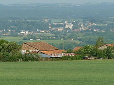
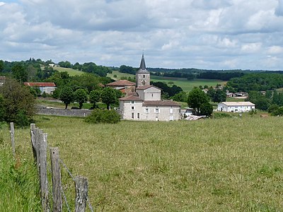 Orgedeuil with the massif in the background, looking towards the northeast
 Wine-growing region on the south-western slopes near Saint-Sornin
 View over Chazelles to the Massif de l'Arbre on the horizon


See also
literature
- J.-P. Floc'h et al: La Rochefoucauld . In: Carte géologique de la France at 1/50 000 . tape 1831 . BRGM.