Monts de Blond
| Monts de Blond | |
|---|---|
|
Location of the Monts de Blond in the Massif Central |
|
|
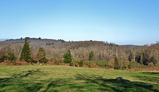
The Monts de Blond from the west |
|
| Highest peak | Les Chapus and Les Marcoux ( 514 m ) |
| location | Department of Charente and Department of Haute-Vienne , (Central France ) |
| part of | Massif Central |
| Coordinates | 46 ° 1 ' N , 1 ° 3' E |
| rock | granite |
| surface | 90 km² |
The Monts de Blond , besides the Massif de l'Arbre the western-most outposts of the French Massif Central . They reach a height of 514 meters above sea level.
etymology
The Monts de Blond are named after the municipality of Blond in the Haute-Vienne department .
geography
The Monts de Blond are located on the border between the Charente and Haute-Vienne departments . They follow the Massif de l'Arbre in the Charente department in a north-easterly direction and generally already exceed 400 meters in height. They are counted among the Monts de la Marche , the western foothills of which they form.
The Monts de Blond are located almost 30 kilometers northwest of Limoges on the western border of the Haute-Vienne department in the Nouvelle-Aquitaine region . It is a very small massif with a maximum length of 15 kilometers in an east-west direction and 6 kilometers from north to south. Its altitudes also extend to the neighboring Charente department, above all to the area of the municipality of Montrollet , where they are 368 meters in Rocher aux Oiseaux and 340 meters near Saint-Christophe . The massif has a steeper north and east side, but dips relatively gently in the west.
Two points in the massif are 514 meters high: the first is at Les Marcoux , between the hamlets of Le Charlet and La Bétoulle ; the second is Les Chapus near the hamlet of La Bachellerie . Both terrain points belong to the municipality of Blond. Other municipalities in the area of the massif are Bussière-Boffy (now part of Val d'Issoire ), Montrol-Sénard , Mortemart , Cieux , Vaulry and Chamboret in the Haute-Vienne department and Montrollet and Saint-Christophe in the Charente department.
Hydrography

Several rivers have their source in the Monts de Blond, including the Marchadaine and the Issoire .
geology
Geologically, the Monts de Blond lie entirely on the crystalline basement of the northwestern Massif Central . By far the largest part of the massif (60 square kilometers) is underlain by the blond leuco granite. This peraluminous, lithium- rich leucogranite penetrated the Upper Carboniferous along the Oradour Fault , a right-hand, southeast-trending lateral shift, into amphibolite- bearing paragneiss of the Upper Gneiss blanket and the associated Upper Devonian Cieux-Vaulry granite . The Oradour fault cuts off the blond leuco granite from the glane granite in the southwest .
The main facies of the blond leukogranite are characterized by the presence of the mica protolithionite and lithium muscovite as well as magmatic andalusite . It can be divided into four varieties:
- an internal medium-grain leuco granite with large mica in the north
- an annular non-porphyry two-mica leuco granite
- a ring-shaped porphyry two-mica leuco granite
- an external medium-grain two-mica leuco granite in the south of the massif
A localized lower facies, which occurs only southeast of the hamlet of Roche near Bussière-Boffy, is similar to the main facies, but contains neither protolithionite nor andalusite. A very late, very differentiated and fluorine- rich gastric surge produced ongonites containing topaz and albite , including a fine-grained leuco granite (also southeast of Roche ), topaz-containing micro-granite veins and topaz-containing aplites .
The age dates published so far for the blond leuco granite vary between 319 and 301 million years ( Bashkirian to Gzhelian ).
Mining
On the western edge of the Blond Leukogranite is the Vaulry mine, where tin and tungsten are mined.
ecology
The landscape in the Monts de Blond is mainly composed of deciduous forests. Characteristic are granitic rocks seas with evocative names such as Feenfels , mushroom , Rüttelstein of Boscartus or sacrificial stone . The Rochers de Puychaud are a well-known sea of rocks . The villages are in turn surrounded by meadows.
Some dry heaths have been preserved, for example on the Butte de Frochet in the municipality of Val d'Issoire or near Ceinturat , as well as some moors such. B. the moor of Pioffret . Both heaths and moors are under nature protection and have the status of an ecological protection zone (ZNIEFF). The entire massif is also registered as an object to be protected ( French: site naturel classé ) because of the rural aspect of its villages and its various ecosystems .
history
In the Monts de Blond there are numerous witnesses to the megalithic culture such as menhirs and dolmens . The menhir of Arnac , the menhir of Ceinturat , the dolmen des Termisseaux or the sacrificial stone of Ceinturat are to be mentioned .
Individual evidence
- ↑ Vallance, J., Cathelineau, M., Marignac, inter alia: Microfracturing and fluid mixing in granites: W- (Sn) ore deposition at Vaulry (NW French Massif Central) . In: Tectonophysics . tape 336 , 2001, pp. 43-61 .


