Geology of the Massif Central
The geology of the Massif Central begins in the Neoproterozoic , and its history continues to this day. The Central Massif ( French Massif Central ) is one of the two large basement massifs in France with the Armorican Massif . The massif was mainly formed by the Caledonian and the Variscan mountain formation , but also shows alpid characteristics - so its strong Cenozoic volcanism was probably triggered by the alpine orogeny . Zirconia dates from around 3000 million years ( Archean ) prove its great age. Structurally, the Massif Central consists mainly of a stack of synmetamorphic basement blankets .
introduction
The open basement of the Massif Central has roughly the shape of a triangle standing on its apex. Due to its size - the Massif Central measures around 500 kilometers in north-south direction with a maximum width in east-west direction of around 340 kilometers - it is part of several tectonic areas that were formed during the Variscan orogeny.
The main part belongs to the Ligero-Arvernian zone (often also referred to as its own small continent Ligeria ), but the Morvan located in the extreme northeast is already part of the Morvano-Vosgian zone , which in turn merges further east into the Moldanubian zone . All of these zones form the internal part of the Variscan orogen , which can be identified as follows:
- it contains remains of oceanic crust that was subducted from the Silurian to the Devonian .
- the approach of Gondwana to the Cadomian continental block , part of Armorica , and further to the east to the Saxothuringian Central German Threshold led to a continental collision in the period from Devon to Carboniferous , which sheared the basement and set large gneiss blankets in motion. In contrast to the Vosges further east, the ceiling transport in the Massif Central generally took place in southern directions.
- after resolution of thrusting it came to the uplift of the mountains that ran diachronic. It began in the west and north of the Massif Central already 380 million years ago (in the Upper Devonian , Frasnian ), but in the southern part only 350 million years ago in the Lower Carboniferous ( Tournaisian ). Further east in the Vosges, the elevation started much later (330 million years ago at the end of the Viséum ).
In the extreme south, the Massif Central still has a share in the Montagne-Noire Zone (this belongs together with the Pyrenees to the small continent Aquitania ), which no longer has any basement blankets and, of its neoproterozoic basement, the non- to low- metamorphic Paleozoic sedimentary blankets in the course of the uplift have slipped southwards.
Geographical structuring
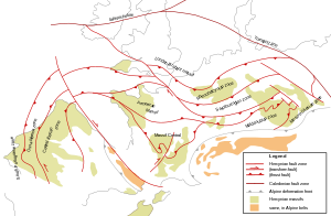
The Massif Central is crisscrossed by several significant crustal faults and fractures , which allow a spatial structure.
The most important of these faults is undoubtedly the 250-kilometer, north-northeast-south-southwest-trending Sillon Houiller , which then merges southward into the Toulouse fault . The Sillon Houiller separates the non-volcanic western part from the volcanic central and eastern part.
The Oligocene Limagne Graben reaches 150 kilometers deep into the Central Massif from the north and almost cuts through the massif in the direction of the Grands Causses .
The central part of the Massif Central to the west of this constriction bears stratovolcanoes such as the Cantal (Europe's largest volcanic building) and the Monts Dore (with the Puy de Sancy ), as well as the cinder cones , lava domes and maars of the Chaîne des Puys .
The eastern part extends from the Morvan in the north to the Cevennes in the south. It falls abruptly to the boundary of the Bresse moat and its extension into the Bas Dauphiné . The expansion fractures beginning on the southeastern edge already lead to the tectonic province of the oceanic Liguro-Provençal basin . The Oligocene Roanne Trench and the Plaine de Forez of the same age form a further deep cut in the basement structures in the eastern part, similar to the Limagne Trench further to the west. The north-east-south-west striking Permian incursion basin of Blanzy - Le Creusot gives the Morvan to the north its own position.
Another important east-southeast-west-northwest trending turning point lies at the level of Decazeville and Figeac , which almost completely separates the southern Rouergue with the Montagne Noire from the main north mass of the Massif Central.
In summary, it can be said that the Massif Central is an asymmetrical basement block that was pushed out on its eastern edge by the Alpidic and on its southern edge by the Pyrenees orogeny. These edges show abrupt transitions to their surroundings. The massif also reaches the highest topographical heights on average and then gradually falls off towards the northwest towards the Limousin and Marche , where it descends relatively gently under the sediments of the Aquitaine Basin and the Paris Basin . This somewhat simplistic scheme is locally complicated by the numerous faults and fractures - the highest point of the Massif Central is, for example, the Puy de Sancy with 1886 meters in the central part.
Tectono-metamorphic areas
According to M. Chenevoy (1974), the crystalline basement of the Massif Central is subdivided into three large tectono-metamorphic areas:
- Arvernian area ( Auvergne )
- Ruteno-Limousin area ( Rouergue - Limousin )
- Cevenolian area ( Cevennes )
The Arvernian area

The Arvernian area is the structurally lowest area and has a parautochthonous character. It frames some bulges in the basement such as the Saint Mathieu Cathedral , the Sussac Cathedral and the huge Plateau de Millevaches (all in the deeply eroded western part). Its main distribution area, however, is the Auvergne (hence the name), plus the western Marche, northern Morvan, Lyonnais and Livradois ( Haut Allier ).
The now highly metamorphic rocks - essentially the amphibolite facies were reached and medium-pressure, high-temperature conditions prevailed - were originally deposited as flysch series on the northern continental margin of Gondwana . The flysch consisted of a monotonous, rhythmic alternation of clayey ( Pelite ) and sandy layers ( Grauwacken ) and could reach an astonishing thickness of 15 kilometers and more. In the middle part of the series, bimodal volcanogenic sediments are interposed, which can be several thousands of meters thick. Rhyolithic material predominates in them , but tholeiitic basalts , and rarely peridotite and carbonate lenses , also occur. For the Neoproterozoic sediment sequence, called Briovérium by French geologists , a maximum age of 650 million years is given, but possibly only 600 to 550 million years ( Ediacarium ).
The former sediments of the Arverni area were essentially only metamorphosed during the Acadian phase (400-350 million years ago) in the course of the Caledonian mountain formation. The pressure reached 0.6-0.8 GPa (6-8 kilobars), corresponding to a sinking depth of 25-30 kilometers with a temperature gradient of 20-25 ° C per kilometer. It emerged Migmatite ( Anatexite ) on the base, followed by gneiss, mica schists and finally greenschist facies sericite and chlorite at higher altitudes. The volcanic inclusions were metamorphosed into leptynites and amphibolites .
The rock sequence also contains Augengneise (sheared orthogneiss ), which emerged from former porphyry granitoids . Their age is around 500 million years ( furongium ).
The Ruteno-Limousin area
The metamorphic rocks of the Ruteno-Limousin range are limited to the Limousin, the Rouergue, the eastern Marche, the Châtaigneraie , the southern Margeride and the western edge of the Cevennes. The sediment package begins with the same sequence as in the Arverni area. In contrast to the Arvernian area, the Ruteno-Limousin area still has a subsequent Paleozoic series. The latter begins in the Lower Cambrian with a powerful volcanogenic succession of rhyolitic composition. This is followed by the dated Upper Cambrian, Ordovician and Silurian .
The Limousin was also metamorphosed exclusively during the Acadian phase. In the Rouergue, however, the Hercynian metamorphosis also overlaps , which took place under low pressure conditions but at high temperatures.
The Cevenolian area
The Cevenolian area includes the Cevennes, the Montagne Noire, the Albigeois and the Lyonnais. Here, too, the well-dated Paleozoic (Cambrian and Ordovician) follows the crystalline slate of the Arverni area. This Paleozoic is not metamorphic in the Montagne Noire, but further north in the Albigeois and in the Cevennes it assumes an increasingly metamorphic character of Hercynian characteristics.
Low metamorphic rock series

Low-metamorphic, green-slate-facial rock series are underrepresented in the Massif Central and mostly only occur in peripheral locations. Examples are the Génis and Thiviers-Payzac units in the Bas-Limousin , the Mazerolles unit in the Haute-Charente , the Brévenne unit in the northeast (Lyonnais) and the slates of the Albigeois in the south.
The Génis unit, for example, shows the following structure (from young to old):
- Génis Greenschist
- Conodonts - leading calcareous lenses from the Obersilur
- Génis sericite slate , contain acritics from the Ordovician
- silicified arkose the Moulin du Guimalet, any affinity to the Ordovician Grès armoricain of Brittany
- Génis porphyroids , former rhyolithic ignimbrites (metaignimbrites) from the turn of the Cambrian / Ordovician
- Excideuil sericite slate
The Thiviers-Payzac unit is mainly composed of rhyodacite tuffs , greywacke and siltites .
The Mazerolles unit consists of aluminum-rich mica schists with passages rich in quartz. It emerged from former pelites and siltites and probably dates from the Cambrian.
The Brévenne unit is an ophiolithic ceiling of the Upper Devonian age. It consists of pillow lavas , diabase , gabbros , ultramafic rocks, silica schist and massive sulphide ores.
Sedimentary development
Non-metamorphic rock series are very important for the paleogeographical reconstruction, as they unadulterated the former conditions. In the Massif Central, unfortunately, they often only occupy a subordinate position and have mostly only been preserved in peripheral locations. This fact of course makes it difficult to understand the conditions and processes at that time.
Pre-carbon series
Pre-carbonic non-metamorphic sediments can be found in two areas:
- in the Montagne Noire on the southern edge and
- in the Morvan in the northeast
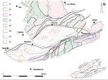
On the southern edge of the Montagne Noire there is an almost complete series of sediments, ranging from the Cambrian to the Lower Carboniferous .
The Cambrian begins with basal rhyolites, followed by the Grès de Marcory (a sandstone), archaeocyathid limestone and, above all, slate and sandstone. Ordovician and Silurian consist mainly of clay slate, whereas the Devonian is made up exclusively of carbonates from the Mediterranean facies.
At the northern edge the series is a little less complete, the Upper Ordovician is missing . As compensation, the progressive transition of the Kambro-Silurian into the metamorphic equivalents of the Albigeois can be observed here.
In the Morvan, Devonian sediments of the Givetian , Frasnian and Famennian are exposed. Givetium and Frasnium are formed as reef limestone . The famennium consists of clymenia- bearing slate with Spilite interlayers.
Lower carbon
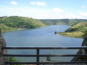
Lower Carboniferous sediments lie in a band that extends from the Roannais over the Beaujolais to southwest of Montluçon .
The sequence begins in the Lower Viséum - the Tournaisium is generally absent in the Massif Central, with exceptions in the Morvan - with clayey-sandy sediments, followed by Grauwacken, conglomerates and carbonates in the Middle Viséum . The transgressive Upper Viséum with the so-called Tufs anthracifères , which have a wide spatial distribution and can become very powerful, is particularly important . These are pyroclastic volcanic tuffs of rhyolite or Dacite composition. The name is derived from the anthracite inclusions, which indicate a parallel milieu near a shallow lake.
Coal leading upper carbon
After the strong tectonic movements in the period 325 - 305 million years BP ( Serpukhovian , Bashkirian and Moskovian - Sudetic and Asturian phases ) with simultaneous granitization , late Orogenic fracture tectonics occurred in the Kasimovian . The resulting collapse basins, mostly only small in size, were filled with limnic sediments, including conglomerates, sandstones, clay slate and coal seams . Local rhyolite deposits can also be observed.
Examples of this are the braziers of Ahun , Argentat , Blanzy , Decazeville , Graissessac , Le Creusot , Messeix in Sillon Houiller, Saint-Étienne , Sainte-Foy and Sincey-lès-Rouvray .
The basin sediments were later folded very vigorously during the hall phase between the moving basement blocks.
Permic Burglary Basin
The expansion of the young orogen continued in the Permian as well, and several basins formed, mainly along the periphery of the Massif Central, inside there are only sparse remains. The sediment fill was continental and detritic in nature, mainly red sandstones .
Examples of Permian intrusion basins are the Autun , Blanzy , Brive , Espalion , Moulins and Saint-Affrique basins .
Mesozoic
During the Mesozoic , the Central Massif remained mainland, the erosion that had already begun in the Upper Carboniferous continued. Exceptions are the edges of the massif and the sea gulf of the Causses ; here the Jurassic Sea left behind some very powerful limestone formations.
Cenozoic
With the beginning of the Cenozoic , the Massif Central was raised significantly in the course of the formation of the Alps and Pyrenees, and explosive volcanism began as early as the Paleogene , which should continue into the present.
In the late Eocene , the so-called Sidérolithique , iron-rich deposits close to laterites , arose, which reflect an intensive leveling of the massif and its edges under subtropical conditions.
A strong crustal expansion began in the middle Eocene ( Lutetian ), but reached its peak in the Oligocene ; it created large, north-south and north-north-west-south-south-east trending asymmetrical ditches (Cher ditches, Bresse and Limagne ditches, as well as Roanne ditches, Plaine du Forez and several smaller ditch structures). The sediment filling is limnic with partly volcanic inclusions, the so-called Pépériten . The thickness of the continental trench sediments can swell to over 2500 meters.
Towards the end of the Miocene , the precursors of the Cantal and Monts Dore stratovolcanoes formed. Mighty alkali basalts were deposited in the eastern Velay and phonolite domes penetrated .
In the Pliocene , there was a renewed uplift phase with simultaneously increased erosion rates, and volcanism reached its peak. For example, the Cantal built up to over 3000 meters.
During the last ice age , valley glaciers and smaller ice caps established themselves on Cantal and Monts Dore, as evidenced by moraines and glacial cirques.
In the Chaîne des Puys , the last phreatomagmatic explosion occurred before 3000-4000 years.
Magmatic development
Deep rocks
Igneous deep rocks take up almost half of the surface of the Massif Central, the majority is directly related to tectonic movements during ore formation.
Two generations of granitoids emerged pre-orogenously, i.e. before the mountain formation, one at the end of the Cambrian 500 million years ago, the other in the Upper Ordovician 460 million years ago. Both generations were later deformed into eye or ligament gneisses.
During the mountain-building processes, three generations of migmatites ( anatectic partial melts ) arose :
- Devonian Migmatites. Formed between 385 and 375 million years BP.
- Migmatite of the Visa. Formed between 333 and 325 million years BP.
- Late carbonic migmatites. Only the huge anatectic dome of the Velay granite around 300 million years ago BP was affected .
The tonalites , quartz diorites and diorites of the so-called Limousin tonalite line formed around 360 million years BP. The granitoids of the high aluminum (peraluminous) Guéret type penetrated BP over a period of 360 to 350 million years. The cooling ages of the leuco granites , the monzogranites and the granodiorites are all much younger and are between 325 and 300 million years BP.
Volcanism
Already in the Paleogene (62 million years ago BP) volcanic activities began in the Massif Central, which lasted until the Holocene . The western part of the Massif Central was not affected.
Geochemically, it is an alkaline intraplate volcanism . The range of rocks extracted ranges from picrites and basanites to basalts , Hawaiites , Mugearites , Benmorites , trachybasalts , basaltic trachyandesites and trachyandesites to trachytes , phonolites and rhyolites .
The trigger for this relatively long-lasting volcanism is possibly a hotspot under the Massif Central . Undoubtedly, the effects of the Alpine orogeny on the surrounding area of tension must also be taken into account.
Spatially, volcanism covered the following areas (from north to south):
- Chaîne de la Sioule
- Chaîne des Puys
- Limagne
- Monts Dore
- Forez
- Cézallier
- Cantal
- Devès
- Velay
- Aubrac
- Vivarais
- Plateau du Coiron
- Causses
- Escandorgue - Languedoc
The course of volcanic activities can be divided into three sections:
- Prairie phase. It lasted until the end of the Eocene 36 million years ago BP ( Priabonium ). It consists of around 15 spatially and temporally separated eruptions.
- Drift phase. It lasted until the end of the Middle Miocene 13 million years ago BP ( Serravallian ). It began with a practically volcanite-free initial sedimentation phase that lasted in the south until the Upper Oligocene 27.5 million years ago and in the north until the end of the Oligocene 23 million years ago. In the Limagne Trench, volcanism started again 27 million years ago, in the Plaine du Forez 20 million years ago (in the Burdigalium ).
- Post writing phase - main phase. It provided around 90% of the total output. It began 13 million years ago first in the south in the eastern Velay , and shortly afterwards also in the Cantal . In the north, volcanic activity did not start again until the Messinian 6 million years ago after a long period of rest .
Tectonic evolution
Structural structure
Structurally, the Massif Central is a pile of metamorphic basement blankets that have been pushed onto their southern foreland (Aquitania). The following units can be distinguished (from structurally higher to structurally lower):
- Low to non-metamorphic units. Usually come to lie on the upper or lower gneiss cover with abnormal contact. The Tufs anthracifères , which are discordant, are an exception .
- Upper gneiss cover ( Unité Supérieure des Gneiss ). Has abundant relics of eclogites and granulites at its base , followed by the leptyno-amphibolitical complex and a powerful paragneisserie with anatexites. The two gneiss covers are separated by mylonites . Highest level metamorphic unit.
- Lower gneiss cover ( Unité Inférieure des Gneiss ). It mainly consists of a sequence of metagrauwacke, metapelite and metarhyolite with embedded orthogneiss (eye gneiss) - former alkaline granitoids that penetrated the former sediments between 540 and 430 million years ago. Passes over the parautochthonous unit.
- Parautochthonous mica slate unit ( Unité para-autochthone des micaschistes ). Often found in tectonic windows. Crosses the fold and thrust belt to the south. Consists mainly of mica schists, subordinate to quartzites, very rarely amphibolites and calcareous lenses. The degree of metamorphosis ranged from green slate facies to epidote amphibolite facies.
- Paleozoic fold and thrust belt. Well trained in the Montagne Noire. Lying folds in the kilometer range, thrust direction to the south. Low to non-metamorphic Lower Cambrian up to and including Lower Carboniferous.
- Foreland basin. Filled with turbidites from the Viseum and the Serpukhovium. Extends from the southeastern edge of the Montagne Noire to the Pyrenees. The proximal facies in the Montagne Noire contain olistholiths from the fold and thrust belt.
Dynamic development
Geodynamically, six important tectonic-metamorphic development stages can be distinguished in the Massif Central:
- Stage D 0 . Synchronous with a high pressure to ultra high pressure metamorphosis in the outgoing Silurian mountains about 415 million years ago BP in eclogites and orthogneiss of the upper gneiss cover. This stage is to be equated with the early Variscan Ardennes phase . The pressures reached 1.8 to 2.0 GPa (18 to 20 kilobars) corresponding to a sinking depth of 50 to 60 kilometers, the temperatures were between 650 ° C and 750 ° C.
- Stage D 1 . This is the Acadian phase in the Lower Devonian, already mentioned above, which was of decisive importance for the Massif Central. Large -dimensional isoclinal folds with the associated flat foliation developed . The legs of the folds were torn off along the fold axes , leading to blanket-like crossings. The basement was sheared, and two larger ceiling associations formed, the lower gneiss cover and the upper gneiss cover .
The direction of movement of the hanging wall was towards the southwest. The ceiling bandages, in turn, were then folded (articulated and dump trucks with a wavelength of around 50 kilometers). In this context, anatectic melts formed in the period 385-380 million years BP and the sedimentary parent rocks were migmatized . In the migmatites occasionally are amphibolites retromorphisierte Eclogites included. The conditions of this retromorphosis were 0.7 GPa (7 kilobars) and 700 ° C.
In the north of the Massif Central (Morvan) the upper gneiss cover was covered by undeformed Upper Devonian sediments. The metamorphic development ended in the north 380 million years ago. - Stage D 2 . Breton phase . This stage took place in the period extending from the Upper Devonian to the Lower Carboniferous ( Tournaisium ) (360 - 350 million years BP) and took place under medium pressure / medium temperature conditions. It caused ductile shear movements, the sense of movement was hanging to the northwest.
- Stage D 3 . This stage, which occurred in the Viséum (345 - 325 million years BP), led to thrusts in the south of the Massif Central, which affected the Parautochthon including the folded foreland. The direction of movement here was hanging towards the south-southwest. In the north, synorogenic expansion began at the same time, illustrated by the explosive volcanism of the Tufs anthracifères .
- Stage D 4 . Neovarisian crustal expansion . This stage occurred in the Lower Upper Carboniferous ( Serpukhovian , Bashkirian and Moskovian ). The north-west-south-east running synorogenic crustal expansion caused the penetration of numerous synkinematic leuco granites and monzogranites .
- Stage D 5 . Postorogenic collapse in the Upper Upper Carboniferous ( Kasimovium ). The expansion now took place in a north-north-east-south-south-west direction and the Upper Carboniferous coal-bearing collapse basins were created.
Paleogeography
It is generally accepted that the Massif Central, together with the southern part of Armorica, originally belonged to the northern edge of Gondwana . The northward drifting of Armorica and its eastern continuations (also known as Hun-Superterran ) from Gondwana in the Lower Ordovician opened the Paleotethys . As a result, the northward oceans, the Rhine Ocean and the Rheno-Hercynian Ocean , became more and more narrowed. The narrowing caused a subduction of the Rheic or Rhenohercynian Ocean under Armorica and under the Hun super terran. The geodynamic stage D 2 corresponds to this subduction stage in the Massif Central . The continental collision between Gondwana and Laurussia in the Lower Carboniferous corresponds to stage D 3 .
This is just one of many model concepts. Other models usually only differ from this in terms of other subduction directions; the arrangement of the microcontinents and continent fragments also plays a decisive role in the respective reconstruction. The situation is further complicated by the dextral shear movements in the Variscan orogen, which make a simple opening / closing very questionable.
As an introduction to this problem, see the work by Stampfli et al. (2002).
Final consideration
The Massif Central shows a very complex geological development. Its strong erosive leveling since the orogen was raised has mainly exposed the deeper, polymetamorphic, crystalline basement. Supracrustal rock series of sedimentary origin are severely underrepresented and usually only occur in peripheral zones. This fact makes the reconstruction of the geodynamic relationships much more difficult.
A high-pressure metamorphosis caused by crust subduction at the turn of the Silurian / Devonian was followed by a multiphase dynamometer metamorphosis in the Devonian / Lower Carboniferous caused by crust narrowing with an intersecting sense of movement (the well-known x of the variscus). The last two phases in the Upper Carboniferous , which occur with crust expansion , again show intersecting directions of movement. The strong expansion also resulted in pronounced granitization with associated mineralization .
The crossing sense of movement also manifests itself spatially in the Massif Central. If a north-west-south-east trending structuring predominates in the west and also in the central part, the structures in the east bend clearly in the south-west-north-east direction.
Mention should also be made of the very diachronous thrusts and elevations that indicate a general temporal migration from north to south. The thrusts in the north began around 385 million years ago, whereas they only became noticeable in the Montagne Noire in the extreme south between 325 and 315 million years ago.
Individual evidence
- ↑ C. Pin, J.-L. Paquette: A mantle-derived bimodal suite in the Hercynian Belt: Nd isotope and trace element evidence for a subduction-related rift origin of the Late Devonian Brévenne metavolcanics, Massif Central (France). In: Contrib Mineral Petrol. 129, 1998, pp. 222-238.
- ↑ Pierre Nehlig, Pierre Boivin, Alain de brat, Jean Mergoil, Gaëlle Prouteau, Gérard Sustrac, Denis Thiéblemont: Les volcans du Massif Central. ( Memento of the original from November 22, 2009 in the Internet Archive ) Info: The archive link was automatically inserted and has not yet been checked. Please check the original and archive link according to the instructions and then remove this notice. In: Revue Géologues. Numéro special Massif central. BRGM 2003.
- ↑ P. Ledru, G. Courrioux, C. Dallain, JM Lardeaux, JM Montel, O. Vanderhaeghe, G. Vitel: The Velay dome (French Massif Central): melt generation and granite emplacement during orogenic evolution. In: Tectonophysics. 342, 2001, pp. 207-237.
- ^ W. Engel, R. Feist, W. Franke: Le Carbonifère anté-stéphanien de la Montagne Noire: reports entre mise en place des nappes et sédimentation . In: Bulletin du Bureau des Recherches Geologiques et Minières de France . tape 2 , 1980, p. 341-389 .
- ↑ Michel Faure, Jean-Marc Lardeaux, Patrick Ledru: A review of the pre-Permian geology of the Variscan French Massif Central. Les grands traits de l'évolution anté-permienne du Massif central français. In: Comptes Rendus Géoscience. Volume 341, No. 2-3, February 2009, pp. 202-213.
- ↑ C. Pin, J.-J. Peucat: Ages des épisodes de métamorphisme paléozoïques dans le Massif central et le Massif armoricain . In: Bulletin de la Société Géologique de France . tape 8 . Paris 1986, p. 461-469 .
- ↑ JM Lardeaux, P. Ledru, I. Daniel, S. Duchène: The Variscan French Massif Central - a new addition to the ultra-high pressure metamorphic "club". Exhumation processes and geodynamic consequences . In: Tectonophysics . tape 323 , 2001, p. 143-167 .
- ^ Gérard M. Stampfli, Jürgen F. von Raumer, Gilles D. Borel: Paleozoic evolution of pre-Variscan terranes: From Gondwana to the Variscan collision . In: Geological Society of America Special Paper . tape 364 . Boulder 2002, p. 263–280 ( unil.ch [PDF; 1,2 MB ]).
swell
- Service Géologique National (Ed.): Carte géologique de la France au millionième . Editions BRGM, 1996.
- Michel Faure, Jean-Marc Lardeaux, Patrick Ledru: A review of the pre-Permian geology of the Variscan French Massif Central. Les grands traits de l'évolution anté-permienne du Massif central français . In: Comptes Rendus Géoscience . Volume 341, No. 2–3 , February 2009, pp. 202-213 .
- JM Peterlongo: Massif Central . In: Guides géologiques régionaux . Masson, 1978, ISBN 2-225-49753-2 .

