
Argentat
| Argentat | ||
|---|---|---|
.svg)
|
|
|
| local community | Argentat-sur-Dordogne | |
| region | Nouvelle-Aquitaine | |
| Department | Corrèze | |
| Arrondissement | Grommet | |
| Coordinates | 45 ° 6 ′ N , 1 ° 56 ′ E | |
| Post Code | 19400 | |
| Former INSEE code | 19010 | |
| Incorporation | January 1, 2017 | |
| status | Commune déléguée | |
| Website | www.argentat.fr | |

Argentat is a town and commune Déléguée in the French municipality of Argentat-sur-Dordogne with 2,874 inhabitants (at January 1, 2017) in the department of Corrèze in the region Nouvelle-Aquitaine .
The municipality of Argentat merged with Saint-Bazile-de-la-Roche on January 1, 2017 to form the new municipality of Argentat-sur-Dordogne .
Geographical location
Argentat is located at the junction of the Route Nationale N120 over the Dordogne, in a protected, climatically favorable valley location. The towns of Brive-la-Gaillarde in a west-northwest direction and Aurillac in an east-southeast direction can be reached via the N120 , each around 30 km away. Two kilometers above Argentat, a dam, the Barrage d'Argentat , dams the river. 21 km downstream is the charming and historically interesting town of Beaulieu-sur-Dordogne with its former Benedictine abbey. The prefecture of the Tulle department is located around 35 kilometers to the north-west. The community is on the western edge of the Xaintrie .
Neighboring municipalities of the municipality of Argentat were Saint-Bazile-de-la-Roche in the north, Saint-Martial-Entraygues in the northeast, Hautefage in the east, La Chapelle-Saint-Géraud in the south, Monceaux-sur-Dordogne in the southwest, Neuville and Saint- Chamant in the west and Saint-Bonnet-Elvert in the northwest.
coat of arms
Description : In blue two opposing faces, beards pointing to the head of the shield , silver keys on stakes .
population
With 2977 inhabitants (as of January 1, 2014), Argentat was one of the larger municipalities in the Corréze department.
Population development
| year | 1962 | 1968 | 1975 | 1982 | 1990 | 1999 | 2009 | 2017 |
| Residents | 3196 | 3256 | 3371 | 3234 | 3189 | 3125 | 3052 | 2874 |
| Sources: Cassini and INSEE | ||||||||
history
Argentat developed into a prosperous town in the 16th and 17th centuries. The economic basis of this prosperity was the transport of oak wood for the production of wine barrels to Bergerac .
The municipality of Argentat merged with Saint-Bazile-de-la-Roche on January 1, 2017 to form the new municipality of Argentat-sur-Dordogne.
Attractions
- Grave de Roland a Neolithic menhir in an acceptable condition.
- The small town on the banks of the Dordogne is home to an ensemble of pretty town houses and fishermen's houses in the center and on the river bank.
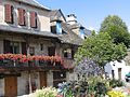
Fishermen's houses
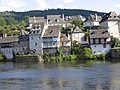
Left bank

Menhir Grave de Roland
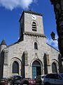
St. Pierre Church
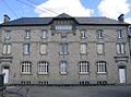
School with former separate entrances for girls and boys


Barrage d'Argentat
The Argentat dam is used as a hydroelectric power station. It is the fifth in a series of dams on the upper reaches of the Dordogne. The dam is 35 m high and 190 m long. The power station's machinery is the same as those at the Rance tidal power station in Brittany . At the time, the dam was also used to test this new type of machine.
Town twinning
Argentat has had a partnership with the German city of Bad König in the Odenwald since 1982 .
literature
- Auvergne. Perigord, Berry, Limousin (= The Green Travel Guide ). Michelin Reiseverlag, Karlsruhe 2003, ISBN 2-06-000107-2 , pp. 76-77.