
Montluçon
| Montluçon | ||
|---|---|---|
.svg)
|
|
|
| region | Auvergne-Rhône-Alpes | |
| Department | Allier | |
| Arrondissement | Montluçon | |
| Canton |
Montluçon-1 Montluçon-2 Montluçon-3 Montluçon-4 |
|
| Community association | Montluçon Community | |
| Coordinates | 46 ° 20 ′ N , 2 ° 36 ′ E | |
| height | 194-364 m | |
| surface | 20.67 km 2 | |
| Residents | 35,653 (January 1, 2017) | |
| Population density | 1,725 inhabitants / km 2 | |
| Post Code | 03100 | |
| INSEE code | 03185 | |
| Website | www.mairie-montlucon.fr | |
 Montluçon Town Hall |
||

Montluçon is a French city in the Auvergne-Rhône-Alpes region . With 35,653 inhabitants (as of January 1, 2017) it is the largest city in the Allier department . Montluçon is the seat of the sub-prefecture ( sous-préfecture ) of the arrondissement Montluçon and seat of the community association Montluçon Communauté .
geography
Montluçon is located in the center of France at a bend in the upper Cher and is the end point of the abandoned Canal de Berry (southern section).
To the north of Montluçon lies the 106 km² national forest Forêt de Tronçais .


Population development
| year | 1962 | 1968 | 1975 | 1982 | 1990 | 1999 | 2006 | 2016 |
| Residents | 55.184 | 57,871 | 56,468 | 49,912 | 44,248 | 41,350 | 39,889 | 36,147 |
Attractions
See also: List of Monuments historiques in Montluçon
- Old town
- Church of St-Pierre: 12./13. Century, Romanesque, single-nave, four round columns supported crossing tower; Baptismal font and statue of Maria Magdalena from the 15th century, the church is in the north of the old town
- Notre-Dame church: Romanesque-Gothic
- Château des Ducs de Bourbon ( Castle of the Bourbon Dukes ): on Mont Luçon, a granite hill above the city, built in half-timbered style from the mid-13th century
- Musée des Musiques Poulaires et de la Résistance (in the castle) with over 700 historical and modern instruments and - one floor higher - the representation of the Resistance in general and in the region.
- Musée / Château de la Louvière: from 1926 in the style of the Ancien Régime , built in the Italian-English style in the middle of a larger park
- Circuit des Mégalithes in the northeast of Montluçon
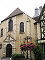
Facade of the Saint-Pierre church
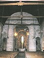
Saint-Pierre, interior view

Notre-Dame church

Notre-Dame, interior view


Economy and Transport
The city is the economic metropolis of the Bourbonnais with numerous industrial companies.
The upswing from a medieval town to a town of industrial goods production began with the completion of the Canal de / du Berry in 1841, which connected the iron ore deposits of the Berry with the coal deposits at Commentry .
After a crisis at the beginning of the 20th century when the deposits were exhausted, mechanical engineering, chemistry, electrical engineering and furniture manufacturing dominate the city today.
The airport Aéroport de Montlucon - Gueret is located about 30 km away.
history
After the Armistice of Compiègne during the Second World War, Montluçon was located in the southern zone of France controlled by the Vichy regime . There was a Gestapo headquarters in Montluçon . This was blown up by the Resistance ; the British agent Nancy Wake was instrumental in this.
Town twinning
Personalities
sons and daughters of the town
- François Bauchet (* 1948), designer
- Roger Chaput (1909–1995), jazz musician and visual artist
- Jules Cluzel (* 1988), motorcycle racer
- Marx Dormoy (1888–1941), socialist politician and interior minister
- Ophélie Meilleroux (* 1984), football player
- André Messager (1853–1929), conductor and composer
- Gabrielle Robinne (1886–1980), actress
- Florian Vachon (* 1985), racing cyclist
- Jean Val Jean (* 1980), porn actor
- Roger Walkowiak (1927-2017), former French cyclist
People with a relationship to the city
- Edmé Boursault (1638–1701), writer, died in Montluçon
- Saul Friedländer (* 1932), attended the Catholic boarding school in Montluçon
- Audrey Tautou (* 1976), French actress, grew up in Montluçon
- Fadil Vokrri (1960-2018), Yugoslav soccer player and president of Federata e Futbollit e Kosovës , had a second residence in Montluçon
literature
- Le Patrimoine des Communes de l'Allier. Flohic Editions, Volume 2, Paris 1999, ISBN 2-84234-053-1 , pp. 731-765.
Web links
Individual evidence <
- ↑ Fête du Jumelage avec Guimaraes le 26 avril , website of the Montluçon City Council, accessed on May 16, 2020