Le Vilhain
| Le Vilhain | ||
|---|---|---|
|
|
||
| region | Auvergne-Rhône-Alpes | |
| Department | Allier | |
| Arrondissement | Montluçon | |
| Canton | Bourbon l'Archambault | |
| Community association | Pays de Tronçais | |
| Coordinates | 46 ° 34 ' N , 2 ° 48' E | |
| height | 266-412 m | |
| surface | 26.37 km 2 | |
| Residents | 275 (January 1, 2017) | |
| Population density | 10 inhabitants / km 2 | |
| Post Code | 03350 | |
| INSEE code | 03313 | |
Le Vilhain is a French municipality with 275 inhabitants (at January 1, 2017) in the department of Allier in the region Auvergne Rhône-Alpes (before 2016 Auvergne ); it belongs to the arrondissement of Montluçon and the canton of Bourbon-l'Archambault (until 2015 Cérilly ).
geography
Le Vilhain is located about 29 kilometers north-northeast of Montluçon . Le Vilhain is surrounded by the neighboring communities of Cérilly in the north, Theneuille in the east and north-east, Louroux-Bourbonnais in the south and east, Saint-Caprais in the west and south-west and Le Brethon in the west and north-west.
Population development
| year | 1962 | 1968 | 1975 | 1982 | 1990 | 1999 | 2006 | 2011 | 2016 |
| Residents | 594 | 501 | 361 | 321 | 289 | 267 | 267 | 262 | 268 |
| Source: Cassini and INSEE | |||||||||
Attractions
See also: List of Monuments historiques in Le Vilhain
- Menhir Pierre Chevriau
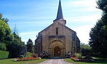
- Saint-Martin church from the 13th century, monument historique since 1933
literature
- Le Patrimoine des Communes de l'Allier . tape 1 . Flohic Editions, Paris 1999, ISBN 2-84234-053-1 , pp. 83-84 .
Web links
Commons : Le Vilhain - collection of images, videos and audio files

