
Urçay
| Urçay | ||
|---|---|---|

|
|
|
| region | Auvergne-Rhône-Alpes | |
| Department | Allier | |
| Arrondissement | Montluçon | |
| Canton | Bourbon l'Archambault | |
| Community association | Pays de Tronçais | |
| Coordinates | 46 ° 38 ′ N , 2 ° 35 ′ E | |
| height | 158-278 m | |
| surface | 12.49 km 2 | |
| Residents | 264 (January 1, 2017) | |
| Population density | 21 inhabitants / km 2 | |
| Post Code | 03360 | |
| INSEE code | 03293 | |

Urçay is a French municipality with 264 inhabitants (as of January 1 2017) in Allier in the region Auvergne Rhône-Alpes (2015 Auvergne ). The municipality belongs to the Arrondissement Montluçon and the municipality association Pays de Tronçais founded in 1999 . The inhabitants are called Urçayais .
geography
The municipality of Urçay is located on the right bank of the Cher , which forms the border with the Cher department and the Center-Val de Loire region , 37 kilometers north of Montluçon and 63 kilometers west of Moulins . The municipal area of 12.49 km² is characterized by a mixture of fields, pastures, meadows and trees. In the east, the community has a 343 hectare portion of the 10,600 hectare oak forest Forêt Domaniale de Tronçais . The districts of La Croix Palais, Pied Bertin, Les Combles, Les Pics, Vaux, Le Riau and Les Landats belong to the municipality of Urçay . Urçay is surrounded by the neighboring communities of Lételon in the north, Braize in the east, Meaulne-Vitray in the south and La Perche (Cher department) in the west.
Place name
When the church was founded in 1793, the place was called Urset ; the spelling changed via Urcay to Urçay, which is still in use today (from 1801).
Population development
| year | 1962 | 1968 | 1975 | 1982 | 1990 | 1999 | 2006 | 2015 | |
| Residents | 403 | 428 | 390 | 324 | 294 | 298 | 287 | 270 | |
| Sources: Cassini and INSEE | |||||||||
Attractions
- Saint-Martin church from the 13th century, since 1989 historique monument reported
- Beaumont Castle
- Croix Pétouillon, a wayside cross in the Forêt Domaniale de Tronçais
See also: List of Monuments historiques in Urçay

Tower of the Saint-Martin church

Croix pétouillon
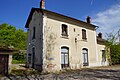
former station building


Economy and Infrastructure
There are six farms in Urçay (cattle and pig breeding).
The Urçay station, opened in 1861 on the route from Bourges to Montluçon, is located on the left bank of the Cher in the municipality of La Perche . The trunk road D 2144 (former Route nationale 144 ) leads through Urçay from Bourges via Saint-Amand-Montrond and Montluçon to Riom .
literature
- Le Patrimoine des Communes de l'Allier. Flohic Editions, Volume 1, Paris 1999, ISBN 2-84234-053-1 , pp. 79-83.
supporting documents
- ↑ toponym on cassini.ehess.fr (French)
- ↑ Urçay on cassini.ehess.fr
- ↑ Urçay on insee.fr
- ^ Entry in the Base Mérimée of the Ministry of Culture. Retrieved October 26, 2018 (French).
- ↑ Farms on annuaire-mairie.fr (French)