
Lavault-Sainte-Anne
| Lavault-Sainte-Anne | ||
|---|---|---|
|
||
| region | Auvergne-Rhône-Alpes | |
| Department | Allier | |
| Arrondissement | Montluçon | |
| Canton | Montluçon-4 | |
| Community association | Montluçon Community | |
| Coordinates | 46 ° 19 ′ N , 2 ° 36 ′ E | |
| height | 203-332 m | |
| surface | 9.08 km 2 | |
| Residents | 1,165 (January 1, 2017) | |
| Population density | 128 inhabitants / km 2 | |
| Post Code | 03310 | |
| INSEE code | 03140 | |
| Website | www.lavault-ste-anne.fr | |
 Lavault-Sainte-Anne town hall |
||

Lavault-Sainte-Anne is a central French city and a municipality in Allier in the region Auvergne Rhône-Alpes . The municipality with 1,165 inhabitants (as of January 1, 2017) belongs to the arrondissement of Montluçon and the canton of Montluçon-4 (until 2015: canton of Montluçon-Sud ). The inhabitants are called Lavaultais .
location
Lavault-Sainte-Anne is about two kilometers south of the city center of Montluçon on the Cher . Lavault-Sainte-Anne is surrounded by the neighboring communities of Montluçon in the north, Néris-les-Bains in the east and south-east, Villebret in the south, Lignerolles in the south and south-west and Prémilhat in the west.
Population development
| year | 1962 | 1968 | 1975 | 1982 | 1990 | 1999 | 2006 | 2013 |
| Residents | 532 | 570 | 1,000 | 1,111 | 1,131 | 1,158 | 1,194 | 1,126 |
| Source: Cassini and INSEE | ||||||||
Attractions
See also: List of Monuments historiques in Lavault-Sainte-Anne
- Church of Sainte-Anne from the 12th century, Monument historique
- La Charité chapel from the 19th century
- La Charité psychiatric institution from the 19th century
- Bisseret Castle
- Bréchaille mill
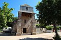
Church of Sainte-Anne

La Charité Psychiatric Clinic

Gate to Bisseret Castle


literature
- Le Patrimoine des Communes de l'Allier. Flohic Editions, Volume 2, Paris 1999, ISBN 2-84234-053-1 , pp. 723-729.