
Néris-les-Bains
| Néris-les-Bains | ||
|---|---|---|

|
|
|
| region | Auvergne-Rhône-Alpes | |
| Department | Allier | |
| Arrondissement | Montluçon | |
| Canton | Montluçon-3 | |
| Community association | Commentry Montmarault Néris Communauté | |
| Coordinates | 46 ° 17 ′ N , 2 ° 40 ′ E | |
| height | 230-441 m | |
| surface | 33.13 km 2 | |
| Residents | 2,553 (January 1, 2017) | |
| Population density | 77 inhabitants / km 2 | |
| Post Code | 03310 | |
| INSEE code | 03195 | |
| Website | www.ville-neris-les-bains.fr | |
 Town hall Néris-les-Bains |
||

Néris-les-Bains is a central French city and a municipality in Allier in the region Auvergne Rhône-Alpes . The health resort with 2,553 inhabitants (as of January 1, 2017) is mainly characterized by the three health resorts and a ten hectare park.
location
The place Néris-les-Bains is located at an altitude of about 350 m in the fertile landscape of the Combrailles in southern Bourbonnais . The city of Montluçon is about eight kilometers (driving distance) to the northwest; the place Colombier with its Romanesque parish church Saint-Patrocle is only about twelve kilometers to the east.
Population development
| year | 1962 | 1968 | 1975 | 1982 | 1990 | 1999 | 2006 | 2012 |
| Residents | 2,837 | 2,917 | 2,836 | 2,924 | 2,831 | 2,708 | 2,726 | 2,588 |
In the 19th century the number of inhabitants rose from around 1,100 to over 2,800 and has remained almost constant since then despite the phylloxera crisis and the mechanization of agriculture .
economy
For centuries, the inhabitants of Néris-les-Bains lived as self-sufficient farmers from agriculture, which also included viticulture; in addition there were regional retail trade and handicrafts. After the phylloxera crisis at the end of the 19th century the wine was for decades a complete standstill, but now again red, rose and white wines are produced in excess of the appellation Val-de-Loire are marketed.
The most important industry in Néris-les-Bains has been the spa since the 19th century. The hyperthermal springs have a temperature of 53 ° C, are weakly radioactive, strongly mineral and rich in trace elements. The thermal water of Néris has a particularly strong influence on the circulatory system. Mainly nerve diseases, rheumatic diseases ( Bechterew's disease ) and gynecological diseases are cured . The course season lasts from May to October.
history
In pre-Roman times, Néris-les-Bains was called Neriomagus , after the Roman conquest 2000 years ago Aquae Nerii . The names have their origins in the Gallic local god Nerius and the Celtic word magos = 'field' or 'level' . The Romans took the springs here, built thermal baths, aqueducts, an amphitheater, temples and villas. At that time the city took up an area of 200 hectares and was of supraregional importance. Saint Patroclus converted the region to Christianity in the 6th century.
Because Néris-les-Bains was not occupied by Germans in 1940, it became a place of refuge for many refugees, mainly Jews, for example the family of Saul Friedländer . Saul Friedländer attended the École communale in Néris-les-Bains for two years .
Attractions
See also: List of Monuments historiques in Néris-les-Bains
- Thermal bath (1826), Monument historique
- Remains of the amphitheater, originally holding 3,000 people, Monument historique
- Camp romain des Chaudes (ancien) (baths / thermal baths, remains), Monument historique
- Villa gallo-romaine de Cheberne et ses dépendances (remains)
- L'oppidum gaulois
- Casino (2nd half of the 19th century), Monument historique
- Alter Bahnhof (1931), Monument historique, architect: Louis Brochet
- Napoleon III style theater
- Saint-Georges church, Romanesque (11th / 12th centuries), with statues from the 17th century, Monument historique
- Saint-Colomban church (18th / 19th century; chapel to the right of the choir from the 15th century)
- La Chapelle Notre-Dame de la Brosse (built 1861)
- St. Joseph's Chapel (from 1894) with a 4 m statue
- Viaducts of the former railway line
- Le viaduc de Sainte-Agathe, 165.5 m long and 40 m high with 7 arches 16 m wide
- Le viaduc de Pérassier, 215 m long and 51 m high with 9 arches 18 m wide
- Le viaduc de Néris, 113 m long and 23 m high with 7 arches 10 m wide
- La Maison du Patrimoine (Museum of the Gallo-Roman Traces)
- Château de Cerclier with chapel from the 17th century
- La nécropole mérovingienne ( 6th century sarcophagi )

Thermal bath
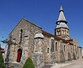
Saint-Georges church

theatre

old trainstation


Partner communities
- Wadersloh (Germany)
literature
- Le Patrimoine des Communes de l'Allier. Flohic Editions, Volume 2, Paris 1999, ISBN 2-84234-053-1 , pp. 766-775.
Individual evidence
- ↑ S. Friedländer, Where memory leads. My life. Munich 2016. p. 17.
- ↑ S. Friedländer, Where memory leads. My life. Munich 2016. p. 25.
- ↑ Thermal baths in the Base Mérimée of the French Ministry of Culture (French)
- ↑ Amphitheater in the Base Mérimée of the French Ministry of Culture (French)
- ^ Camp romain des Chaudes in the Base Mérimée of the French Ministry of Culture (French)
- ↑ Casino in the Base Mérimée of the French Ministry of Culture (French)
- ↑ Old train station in the Base Mérimée of the French Ministry of Culture (French)
- ↑ Saint-Georges Church in the Base Mérimée of the French Ministry of Culture (French)
- ↑ Maison du patrimoine (French)
- ↑ Histoire de Néris-les-Bains (French)