Hérisson (Allier)
| Hérisson | ||
|---|---|---|

|
|
|
| region | Auvergne-Rhône-Alpes | |
| Department | Allier | |
| Arrondissement | Montluçon | |
| Canton | Huriel | |
| Community association | Pays de Tronçais | |
| Coordinates | 46 ° 31 ' N , 2 ° 43' E | |
| height | 177-327 m | |
| surface | 32.57 km 2 | |
| Residents | 622 (January 1, 2017) | |
| Population density | 19 inhabitants / km 2 | |
| Post Code | 03190 | |
| INSEE code | 03127 | |
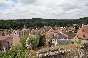
 View of the old town |
||
Hérisson is a French municipality with 622 inhabitants (at January 1, 2017) in Allier in the region Auvergne Rhône-Alpes . It is part of the canton of Huriel in the arrondissement of Montluçon and the municipality of Pays de Tronçais .
geography
The municipality with an area of 32.57 km² is located on an arch of the Aumance river , a tributary of the Cher on the southern edge of the Forêt de Tronçais , about 20 kilometers north of Montluçon .
history
The place was founded in the 5th century after the Gallo-Roman predecessor settlement was destroyed in 475. Under the protection of a donjon (defense construction), Hérission developed into a handsome trading town in the 11th century. In the 12./13. In the 19th century, the Bourbons expanded the castle into a mighty complex, of which the towering ruins of three defensive towers still testify. Until the 17th century, the castle and the town could hold out against enemies; In 1652 the castle was destroyed by Jules Mazarin . Today one lives from agriculture and forestry and a not yet fully awakened tourism . In 1999 there were 709 inhabitants in the community.
Population development
| year | 1962 | 1968 | 1975 | 1982 | 1990 | 1999 | 2006 | 2016 |
| Residents | 916 | 1,043 | 979 | 872 | 801 | 709 | 679 | 627 |
Attractions
See also: List of Monuments historiques in Hérisson (Allier)
- Medieval cityscape with winding narrow streets and old houses (15th - 17th centuries)
- Ruins of the Hérisson castle , Monument historique
- Church of Saint Pierre de Chateloy (Romanesque, 11th century) with wall paintings (restored) from the 13th to 17th centuries, Monument historique
- Bell tower of the Saint-Sauveur church (13th century), monument historique
- Saint-Etienne chapel (15th century), Monument historique
- Notre-Dame church (19th century) with a Gothic baptismal font
- Two fortified city gates ( Porte de la Rivière and Porte de Varenne , 11th / 12th centuries), Monument historique
- Kalvarienberg chapel (17th century) on a hill ( 20 m on foot)
- Herissonnais Terroir Museum
- Parc Louis Bignon
- Mill Butoir
Personalities
- Henri Harpignies (1819–1916), 19th century painter.
literature
- Le Patrimoine des Communes de l'Allier. Flohic Editions, Volume 1, Paris 1999, ISBN 2-84234-053-1 , pp. 438-447.
- Bettina Forst: Auvergne. Cevennes, Massif Central. 2nd, completely updated and expanded edition. Reise-Know-How-Verlag Rump, Bielefeld 2007, ISBN 978-3-8317-1545-9 , pp. 129-131.
Individual evidence
- ↑ Castle ruins in the Base Mérimée of the French Ministry of Culture (French)
- ↑ Saint-Pierre de Chateloy Church in the Base Mérimée of the French Ministry of Culture (French)
- ↑ Saint-Sauveur Church in the Base Mérimée of the French Ministry of Culture (French)
- ↑ Chapel Saint-Étienne in the Base Mérimée of the French Ministry of Culture (French)
- ↑ Porte de la Rivière in the Base Mérimée of the French Ministry of Culture (French)
- ↑ Porte de Varenne in the Base Mérimée of the French Ministry of Culture (French)


