Canton of Huriel
| Canton of Huriel | |
|---|---|
| region | Auvergne-Rhône-Alpes |
| Department | Allier |
| Arrondissement | Montluçon |
| Centralisateur bureau | Huriel |
| Establishment date | March 4, 1790 |
| Residents | 16,037 (Jan. 1, 2017) |
| Population density | 20 inhabitants / km² |
| surface | 813.68 km² |
| Communities | 29 |
| INSEE code | 0307 |
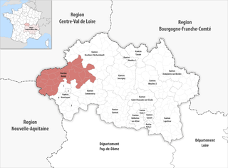
 Location of the canton of Huriel in the Allier department |
|
The canton Huriel is a French Wahlkfreis in the department of Allier in the region Auvergne Rhône-Alpes . It includes 29 municipalities in the arrondissement of Montluçon . His bureau centralisateur is in Huriel .
Communities
The canton consists of 29 municipalities with a total of 16,037 inhabitants (as of 2017) on a total area of 813.68 km 2 :
| local community | Residents January 1, 2017 |
Area km² |
Density of population / km² |
Code INSEE |
Post Code |
|---|---|---|---|---|---|
| Archignat | 336 | 24.35 | 14th | 03005 | 03380 |
| Audes | 433 | 28.26 | 15th | 03010 | 03190 |
| Biceneuille | 294 | 29.75 | 10 | 03031 | 03170 |
| Chambérat | 305 | 28.37 | 11 | 03051 | 03370 |
| Chazemais | 495 | 29.10 | 17th | 03072 | 03370 |
| Cosne-d'Allier | 2,039 | 25.29 | 81 | 03084 | 03430 |
| Courçais | 325 | 26.51 | 12 | 03088 | 03370 |
| Estivareilles | 1.103 | 11.27 | 98 | 03111 | 03190 |
| Skin bocage | 888 | 70.64 | 13 | 03158 | 03190 |
| Hérisson | 622 | 32.57 | 19th | 03127 | 03190 |
| Huriel | 2,646 | 34.92 | 76 | 03128 | 03380 |
| La Chapelaude | 1.007 | 28.60 | 35 | 03055 | 03380 |
| Le Brethon | 325 | 44.61 | 7th | 03041 | 03350 |
| Louroux-Bourbonnais | 211 | 33.02 | 6th | 03150 | 03350 |
| Mesples | 124 | 15.30 | 8th | 03172 | 03370 |
| Nassigny | 182 | 18.32 | 10 | 03193 | 03190 |
| Reugny | 249 | 7.66 | 33 | 03213 | 03190 |
| Saint-Caprais | 90 | 20.14 | 4th | 03222 | 03190 |
| Saint-Désiré | 447 | 41.89 | 11 | 03225 | 03370 |
| Saint-Éloy-d'Allier | 43 | 12.83 | 3 | 03228 | 03370 |
| Saint Martinien | 602 | 25.48 | 24 | 03246 | 03380 |
| Saint-Palais | 164 | 20.30 | 8th | 03249 | 03370 |
| Saint-Sauvier | 348 | 31.47 | 11 | 03259 | 03370 |
| Sauvagny | 89 | 19.41 | 5 | 03269 | 03430 |
| Tortezais | 175 | 24.11 | 7th | 03285 | 03430 |
| Attendance | 396 | 28.94 | 14th | 03288 | 03380 |
| Vallon-en-Sully | 1,564 | 38.02 | 41 | 03297 | 03190 |
| Venas | 235 | 32.15 | 7th | 03303 | 03190 |
| Viplaix | 300 | 30.40 | 10 | 03317 | 03370 |
| Canton of Huriel | 16,037 | 813.68 | 20th | 0307 | - |
Changes in the community since the nationwide reorganization of the cantons
2016: Merger of Givarlais , Louroux-Hodement and Maillet → Haut-Bocage
history
The canton of Huriel was created on March 4, 1790 as part of the establishment of the departments as part of what was then District de Mont-Luçon . With the establishment of the arrondissements on February 17, 1800, the canton was assigned to the new arrondissement Montluçon and redesigned.
The nationwide reorganization of the French cantons resulted in a significant expansion from 14 to 31 municipalities in 2015. The 14 municipalities before the reorganization were Archignat , Chambérat , Chazemais , Courçais , Huriel , La Chapelaude , Mesples , Saint-Désiré , Saint-Éloy-d'Allier , Saint-Martinien , Saint-Palais , Saint-Sauvier , Treignat and Viplaix . Its layout corresponded to an area of 378.46 km 2 . Before 2015 it had a different INSEE code than it does today, namely 0313.
Population development
| year | Residents |
|---|---|
| 1962 | 8,373 |
| 1968 | 8,856 |
| 1975 | 7,706 |
| 1982 | 7,425 |
| 1990 | 7,554 |
| 1999 | 7.153 |
| 2006 | 7,310 |
| 2011 | 7,621 |
politics
| Representative in the departmental council | ||
|---|---|---|
| Term of office | Names | Political party |
| 1994-2015 | Michel Tabutin | PCF |
| 2015– | Séverine Fenouillet Michel Tabutin |
- |
Individual evidence
- ↑ Décret n ° 2014-265 du 27 février 2014 portant délimitation des cantons dans le département de l'Allier published in JORF and in Légifrance (French).
- ↑ Louis Marie Prudhomme: Dictionnaire géographique et méthodique de la République française en 120 départements . First volume. Chez Prudhomme, Paris, 1798, p. 245 ( online in Google book search).