Colombier (Allier)
| Colombier | ||
|---|---|---|
|
|
||
| region | Auvergne-Rhône-Alpes | |
| Department | Allier | |
| Arrondissement | Montluçon | |
| Canton | Commentry | |
| Community association | Commentry Montmarault Néris Communauté | |
| Coordinates | 46 ° 16 ' N , 2 ° 48' E | |
| height | 362-519 m | |
| surface | 12.92 km 2 | |
| Residents | 332 (January 1, 2017) | |
| Population density | 26 inhabitants / km 2 | |
| Post Code | 03600 | |
| INSEE code | 03081 | |
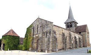
 Saint-Patrocle Church |
||
Colombier is a central French town and municipality ( commune ) with 332 inhabitants (as of January 1, 2017) in the Allier department in the north-west of the Auvergne-Rhône-Alpes region .
location
The place Colombier is at an altitude of about 400 meters above sea level. d. M. in southern Bourbonnais in the Combrailles landscape . The city of Montluçon is about 21 kilometers (driving distance) northwest; It is a good 80 kilometers to the southeast to Clermont-Ferrand .
Population development
| year | 1962 | 1968 | 1975 | 1982 | 1990 | 1999 | 2006 | 2012 |
| Residents | 460 | 436 | 361 | 346 | 331 | 312 | 311 | 325 |
In the 19th century the community recorded a significant increase in population from around 400 to over 1,000 inhabitants. As a result of the phylloxera crisis in viticulture and the mechanization of agriculture , which resulted in the loss of many jobs, the number of inhabitants has since declined continuously to the current lows.
economy
For centuries, the people of Colombier lived as self-sufficient farmers from agriculture, which also included viticulture; in addition there were small trade and handicrafts. After the phylloxera crisis of the wine came decades to a standstill, but now again red, rose and white wines are produced in excess of the appellation Val-de-Loire are marketed. Many vacant houses have been converted into holiday apartments ( gîtes ).
history
No historical information is available for Colombier about the Celtic, Roman, Visigoth and Frankish epochs; However, the history of the neighboring town of Néris-les-Bains, about twelve kilometers to the west, goes back to Roman times. In the 6th century, the missionary and hermit Patroclus worked here , whose bones still rest in Colombier. In the period that followed, a church and perhaps even a monastic community emerged, which in 924 was placed as a priory under the supervision of the Abbey of Saint-Martin in Autun (Burgundy). In the 12th century it was annexed to the Saint-Pierre-et-Saint-Paul priory in Souvigny .
Attractions
See also: List of Monuments historiques in Colombier (Allier)
- The former priory church and today's parish church of Saint-Patrocle is consecrated to Saint Patroclus of Bourges and its main parts ( nave and crossing tower ) date from the 12th century. The church, which was originally built from rubble stones , was extended to the west in the 13th century and received a facade made of precisely hewn stones with an archivolt portal with a multi-pass arch - slightly sharpened at the apex ; at the same time, the outer walls were reinforced by buttresses . The east part ( apse and transept ) was renewed in the 15th century and provided with a rib vault , which rests on small figurative consoles . Parts of the former priory buildings are still preserved. The building was entered in the list of Monuments historiques in 1928 .
- About 300 meters away there is a spring ( Fontaine de Saint-Patrocle ), the water of which was probably already considered medicinal in antiquity, but its border dates from the Middle Ages.
literature
- Le Patrimoine des Communes de l'Allier. Flohic Editions, Volume 1, Paris 1999, ISBN 2-84234-053-1 , pp. 145-149.
Web links
- Colombier, wine info (French)
- Colombier, church and spring - photos + info (French)
Individual evidence
- ↑ Église Saint-Patrocle, Colombier in the Base Mérimée of the French Ministry of Culture (French)
