Montmarault
| Montmarault | ||
|---|---|---|

|
|
|
| region | Auvergne-Rhône-Alpes | |
| Department | Allier | |
| Arrondissement | Montluçon | |
| Canton | Commentry | |
| Community association | Commentry Montmarault Néris Communauté | |
| Coordinates | 46 ° 19 ′ N , 2 ° 57 ′ E | |
| height | 394-498 m | |
| surface | 9 km 2 | |
| Residents | 1,521 (January 1, 2017) | |
| Population density | 169 inhabitants / km 2 | |
| Post Code | 03390 | |
| INSEE code | 03186 | |
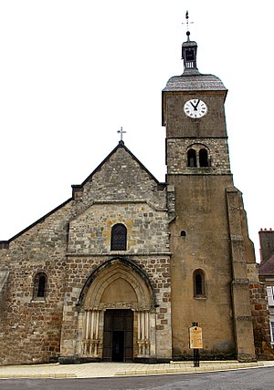
 Saint-Etienne church |
||
Montmarault is a French commune with 1,521 inhabitants (as of January 1 2017) in the department of Allier in the region Auvergne Rhône-Alpes ; it belongs to the arrondissement of Montluçon and the canton of Commentry .
geography
The municipality is located in the Bocage Bourbonnais countryside , around 30 kilometers east of Montluçon . The neighboring municipalities of Montmarault are:
- Sazeret in the north,
- Saint-Marcel-en-Murat in the east,
- Blomard in the south and
- Saint-Bonnet-de-Four to the west.
The place itself is located on a plateau, all of the water that rises there leaves the municipality in a star shape after a short stretch of river.
Transport links
Montmarault is bypassed in the north by the A71 motorway ( Orléans - Clermont-Ferrand ), a motorway exit provides the connection with the lower-ranking road network, e.g. B. National road 79 , Département roads 16 and 46.
Population development
| year | 1968 | 1975 | 1982 | 1990 | 1999 | 2006 | 2016 |
| Residents | 1,446 | 1,366 | 1,443 | 1,597 | 1,663 | 1,572 | 1,520 |
Attractions
See also: List of Monuments historiques in Montmarault
- Saint-Étienne church from the 12th / 13th centuries century
Sons and daughters of the town
- Alphonse Auclair (1898–1969), racing car driver
literature
- Le Patrimoine des Communes de l'Allier. Flohic Editions, Volume 2, Paris 1999, ISBN 2-84234-053-1 , pp. 811-817.
