Montagne Noire

The Montagne Noire (German "Black Mountains") is the southernmost foothills of the French massif Central .
It is only sparsely populated and little developed by traffic. The climate is shaped by the meeting of the climatic areas of the Mediterranean and the Massif Central . The central region has a harsh climate due to its altitude, while the southern slope into the Languedoc plain has a very mild climate due to the influence of the Mediterranean Sea . In combination with favorable soils, this enables viticulture, so that extensive wine-growing regions ( Minervois ) lie at the foot of the mountains .
The water of the creeks flowing south and west in the south-western part of the Montagne Noire is collected and directed to the apex of the Canal du Midi . Without this water, the canal would not be able to operate.
The geological definition of the Montagne Noire differs significantly from the geographic one: the geological Montagne Noire extends significantly further to the east and to the north and is therefore almost four times as large as the geographical Montagne Noire. Geologically significant include the gneiss formations in the west and the complex and fossil-rich Palaeozoic on its south and east sides.
geography
The name Montagne Noire originally only refers to the mountain range around the Pic de Nore (1211 m), which is around 35 km long in east-west direction and around 25 km wide in north-south direction , between Mazamet in the north and Carcassonne in the South lies.
The term was extended at the beginning of the 19th century by geologists Pierre Armand Dufrénoy and Léonce Élie de Beaumont to the areas of Paleozoic rocks east and north of it, so that the Montagne Noire is much larger in the geological sense than the geographic one.
The Montagne Noire forms the end of the Massif Central to the south. Most of it lies in the former Languedoc-Roussillon region , while its northern part belongs to the former Midi-Pyrénées region . In 2016, these two regions were combined to form the new region of Occitanie (Fr. Occitanie). The Montagne Noire is thus located on the border between the Aude , Hérault and Tarn departments .
The Montagne Noire should not be confused with the mountain ranges of the same name in Brittany and the Morvan , which are also known as la montagne noire due to their forests .
geology

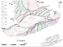
The geological definition of the Montagne Noire differs significantly from the geographic one. In addition to the Montagne Noire in the sense of geographers, it also includes the Monts de l'Orb , the Monts de Faugères and north of the long valley between Mazamet and Bédarieux, the Monts de l'Espinouse and the Monts de Lacaune . It measures around 45 km in a north-south direction and, at around 360 km², is almost four times the size of the Montagne Noire in the geographical sense.
The Montagne Noire in the sense of geologists is the southernmost part of the Massif Central and lies on the south side of the Variscan orogen . It is associated with the northern edge of Gondwana in plate tectonic reconstructions .
To the east, the heavily folded layers of the Montagne Noire are covered by the less deformed rocks of the Bédarieux trench and the Lodève basin . In the west and south, the Mesozoic rocks of the Languedoc are deposited as a gently sloping blanket on the Paleozoic Era.
To the north, the Montagne Noire merges with the crystalline slate of the Albigeois with a blurred border . Its continuation to the east, partly buried under younger strata, forms the Cevennes via the Ride de Lodève with Precambrian and Cambrian rocks , separated from the Montagne Noire by the Mesozoic strata of the Causses .
The Montagne Noire has long been known for its fossil-bearing, largely non-metamorphic Paleozoic Era , which is present here with only local stratigraphic gaps. The fossil richness of the Ordovician and Devonian strata has led to a great deal of research over the past 200 years.
Another special feature of the Montagne Noire is the widespread distribution of large folds with an inverse sequence of layers. The area has been barely affected by recent orogeny, making it a rare opportunity for geological observation of the Paleozoic Era.
The Montagne Noire is classically divided into three zones from north to south:
- North side
- Main ridge
- South side
In the Montagne Noire, on the hill of La Serre near Cabrières, the GSSP of the Devon- Carboniferous border is located.
literature
- Bernard Gèze: Languedoc méditerranéen, Montagne Noire. Guides géologiques régionaux, 191 pages, Masson, Paris 1979. ISBN 2-225-64120-X
Individual evidence
- ↑ La Montagne Noire , website of the Parc naturel régional du Haut-Languedoc ( Memento of the original of October 13, 2007 in the Internet Archive ) Info: The archive link has been inserted automatically and has not yet been checked. Please check the original and archive link according to the instructions and then remove this notice.
- ↑ L'organization des paysages de l'Aude , Atlas des paysages du Languedoc-Roussillon ( Memento of the original of April 16, 2008 in the Internet Archive ) Info: The archive link was inserted automatically and has not yet been checked. Please check the original and archive link according to the instructions and then remove this notice.
- ↑ Gèze 1979, p. 11
- ^ GSSP for Tournaisian Stage. International Commission on Stratigraphy, accessed January 14, 2010 .


