
Haute-Charente
The Haute-Charente is a French landscape in the Nouvelle-Aquitaine region . Geologically, it corresponds to the north -west section of the Massif Central in the north-east of the Charente department and occupies a good quarter of the Charente.
introduction

The Haute-Charente, in French also Charente limousine or Confolentais , is a rural and sparsely populated landscape with 28,749 inhabitants (as of 1999). In contrast to the rest of the Charente department with its calcareous soils of the Aquitaine Basin , it covers the western granitic slopes of the Massif Central. Its main town is Confolens , other larger towns are Chabanais and Chasseneuil-sur-Bonnieure . The traditional language is the Occitan belonging Limousinisch .
Before 1790, the Haute-Charente belonged to the Marche and the Diocese of Limoges . When the departments were founded during the French Revolution , it did not become part of the Haute-Vienne department , but was combined with the Angoumois to form the Charente department.
geography

Geographically , the Haute-Charente roughly corresponds to the eastern half of the Arrondissement of Confolens with a total of 42 municipalities:
Abzac - Ansac-sur-Vienne - Brigueuil - Brillac - Chabanais - Chabrac - Chassenon - Cherves-Châtelars - Chirac - Confolens - Écuras - Esse - Étagnac - Exideuil-sur-Vienne - Eymouthiers - Genouillac - Hiesse - Lésignac-Durand - Lessac - Lesterps - Le Lindois - Manot - Massignac - Mazerolles - Mazières - Montembœuf - Montrollet - Mouzon - Oradour-Fanais - La Péruse - Pressignac - Roumazières-Loubert - Roussines - Rouzède - Saint-Christophe - Saint-Germain-de-Confolens - Saint- Maurice-des-Lions - Saint-Quentin - Saulgond - Sauvagnac - Suris - Verneuil - Vitrac-Saint-Vincent .
The Pays de Charente limousine is a little further west and is made up of a total of 64 municipalities.
Administratively, the Haute-Charente comprises the territories of the Communauté de communes de Haute-Charente plus the Communauté de communes du Confolentais and the Communauté de communes Seuil Charente Périgord .
The Confolentais is surrounded by the following natural regions: in the north by the Civraisien , the Montmorillonais and the Basse Marche with the Monts de la Marche , in the east by the Pays de la Vienne consisting of the Monts de Blond , the area around Saint-Junien and the surrounding area from Rochechouart with the Pays des Feuillardiers and to the west by the Pays d'Horte et Tardoire with the Karst of La Rochefoucauld and the Ruffécois . The Nontronnais begins just a few kilometers further south .

Topographically , the Haute-Charente represents a transition area in which the high plateau of the Limousins gradually merges with the limestone plains of the Angoumois, with the Massif de l'Arbre protruding quite far to the west. This extensive high plateau is located at an average height of 200 meters above sea level. Due to height differences between 150 and almost 370 meters, it can take on a very undulating character with ridges and incised valleys.
In terms of climate , the Haute-Charente is rougher than the rest of the département and is already very close to the conditions prevailing in the Haute-Vienne.
geology
Geologically, the Haute-Charente forms part of the northwestern foothills of the Massif Central , whereas the rest of the Charente is occupied by limestone from the Aquitaine Basin. Pending are rocks of the crystalline basement such as slate , gneiss and granite . The resulting landscape is therefore completely different from the rest of the department - with lush green valleys, with meadows populated by brown Limousin cattle and with houses built in brownish-colored natural stone.
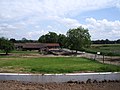
Landscape impressions
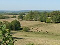
Landscape near Écuras
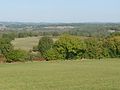
Around Eymouthiers
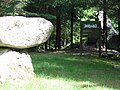
The Rocher aux Oiseaux , the highest point in the Haute-Charente near Montrollet
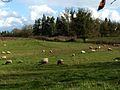
Landscape at Chassenon


history
In addition to the geology, history has also shaped this landscape - this is how the Gallic tribe of the Lemovics once settled here .
The borders of the Diocese of Limoges , inherited from the Romans, follow the natural conditions almost perfectly. Until the French Revolution, the Haute-Charente belonged to the Marche far more often than to the Angoumois. Since the establishment of the departments, it now forms the Charente department together with the Angoumois, part of the Saintonge , a small part of the Périgord and the Poitous .
Linguistic affiliation

As already mentioned, the Haute-Charente belongs to the Occitan language area, the Limousin dialect is spoken. The border to the northern French - the Langues d'oïl , ie for Poitevinischen in the north and Saintongeais in the south - runs with a transition zone, are spoken in both languages (in Saint-Claud and west of Confolens), along a line from Champagne Mouton to Angoulême . It should be noted that the Santongeais was only able to spread properly in the Charente after the turmoil of the Hundred Years War .
The southwestern demarcation of the Haute-Charente to a zone extending from Montbron to Aubeterre-sur-Dronne , in which Occitan is also spoken, roughly follows a line north of Montbron and La Rochefoucauld .
Tourist development
Tourism is gaining a foothold in Haute-Charente , thanks to the Lacs de Haute-Charente , the Festival of Confolens (folklore) and railroad trolleys .
Photo gallery

The Vienne at Chabanais
Entrance to the Gallo-Roman baths of Chassenon

The golf course of the Prèze near Rouzède

The mill on the Goire river at Confolens

Rosary altar by Pressignac


.JPG)