
Saint-Maurice-des-Lions
| Saint-Maurice-des-Lions | ||
|---|---|---|
|
||
| region | Nouvelle-Aquitaine | |
| Department | Charente | |
| Arrondissement | Confolens | |
| Canton | Charente-Vienne | |
| Community association | Charente limousine | |
| Coordinates | 45 ° 58 ′ N , 0 ° 42 ′ E | |
| height | 132–245 m | |
| surface | 50.08 km 2 | |
| Residents | 881 (January 1, 2017) | |
| Population density | 18 inhabitants / km 2 | |
| Post Code | 16500 | |
| INSEE code | 16337 | |
 Town hall (Mairie) of Saint-Maurice-des-Lions |
||

Saint-Maurice-des-Lions is a French municipality with 881 inhabitants (at January 1, 2017) in the department of Charente in the region Nouvelle-Aquitaine (before 2016 Poitou-Charentes ); it belongs to the Arrondissement of Confolens and the canton of Charente-Vienne (until 2015 Confolens-Sud ). The inhabitants are called Saint-Mauriçois .
geography
Saint-Maurice-des-Lions is located about 50 kilometers northeast of Angoulême on the Goire River , a tributary of the Vienne . The community is surrounded by the neighboring communities of Confolens and Esse in the north, Lesterps in the northeast, Saulgond in the east, Chabrac in the southeast, Chirac in the south, Manot in the west and southwest and Ansac-sur-Vienne in the northwest.
Population development
| year | 1793 | 1856 | 1901 | 1962 | 1968 | 1975 | 1982 | 1990 | 1999 | 2006 | 2013 |
|---|---|---|---|---|---|---|---|---|---|---|---|
| Residents | 1,850 | 1,896 | 1,895 | 1,181 | 1,118 | 1.011 | 933 | 1,017 | 932 | 952 | 936 |
| Source: Cassini and INSEE | |||||||||||
Attractions
- Saint-Maurice church from the 12th century, monument historique since 1909
- Chapel of Le Rhus
- Lion's Arch from the Gallo-Roman period

Saint-Maurice Church
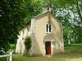
Chapel of Le Rhus

Lion's Arch


