
La Forêt-de-Tessé
| La Forêt-de-Tessé | ||
|---|---|---|
|
||
| region | Nouvelle-Aquitaine | |
| Department | Charente | |
| Arrondissement | Confolens | |
| Canton | Charente North | |
| Community association | Val de Charente | |
| Coordinates | 46 ° 5 ' N , 0 ° 5' E | |
| height | 121-158 m | |
| surface | 10.7 km 2 | |
| Residents | 189 (January 1, 2017) | |
| Population density | 18 inhabitants / km 2 | |
| Post Code | 16240 | |
| INSEE code | 16142 | |
 Town hall (Mairie) of La Forêt-de-Tessé |
||

La Forêt-de-Tessé is a French municipality with 189 inhabitants (as of January 1 2017) in the department of Charente in the region Nouvelle-Aquitaine (before 2016 Poitou-Charentes ); it belongs to the Arrondissement of Confolens and the canton of Charente-Nord (until 2015 Villefagnan ). The inhabitants are called Tesséens .
geography
La Forêt-de-Tessé is located about 45 kilometers north of Angoulême and is surrounded by the neighboring communities of Lorigné in the north, Montjean in the east, La Magdeleine in the south, Theil-Rabier in the southwest and Valdelaume with Pioussay in the west.
Population development
| year | 1793 | 1856 | 1901 | 1962 | 1968 | 1975 | 1982 | 1990 | 1999 | 2006 | 2013 |
|---|---|---|---|---|---|---|---|---|---|---|---|
| Residents | 772 | 808 | 554 | 339 | 284 | 249 | 222 | 212 | 195 | 201 | 201 |
| Source: Cassini and INSEE | |||||||||||
Attractions
- Saint-Junien church
- Tessé fortified house from the 11th / 12th centuries Century, former donjon, monument historique since 1994
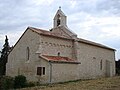
Saint-Junien church

Tessé fortified house
.jpg)

Web links
Commons : La Forêt-de-Tessé - Collection of images, videos and audio files