
Mansle
| Mansle | ||
|---|---|---|
.svg)
|
|
|
| region | Nouvelle-Aquitaine | |
| Department | Charente | |
| Arrondissement | Confolens | |
| Canton | Boixe-et-Manslois | |
| Community association | Coeur de Charente | |
| Coordinates | 45 ° 53 ' N , 0 ° 11' E | |
| height | 55-115 m | |
| surface | 5.75 km 2 | |
| Residents | 1,671 (January 1, 2017) | |
| Population density | 291 inhabitants / km 2 | |
| Post Code | 16230 | |
| INSEE code | 16206 | |
| Website | www.mansle.fr | |
 Mansle Town Hall (Mairie) |
||

Mansle is a French commune with 1,671 inhabitants (as of January 1 2017) in the department of Charente in the region Nouvelle-Aquitaine . The municipality belongs to the Arrondissement Confolens and the canton Boixe-et-Manslois (until 2015: canton Mansle ). The inhabitants are called Manslois .
location
Mansle is about 25 kilometers north of Angoulême on the Charente . Mansle is surrounded by the neighboring communities of Fontenille in the north, Fontclaireau in the east and northeast, Puyréaux in the southeast, Maine-de-Boixe in the south, Cellettes in the southwest and Saint-Groux in the west and northwest.
The former Route nationale 739 (today's D739), which crosses a little east of the community with Route nationale 10 , runs through the municipality .
Population development
| year | 1962 | 1968 | 1975 | 1982 | 1990 | 1999 | 2006 | 2013 |
|---|---|---|---|---|---|---|---|---|
| population | 1324 | 1413 | 1595 | 1486 | 1601 | 1597 | 1527 | 1630 |
| source |
Attractions
- Saint-Léger church from the 12th century with renovations from the 15th and 16th centuries
- Goué Castle
- Bridge over the Charente
- Wash house
- hippodrome

Saint-Léger church
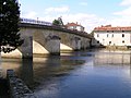
Bridge over the Charente


Community partnerships
There is a partnership with the German municipality of Korb in Baden-Württemberg.
Web links
Individual evidence
- ^ Cassini and INSEE