
La Chapelle (Charente)
| La Chapelle | ||
|---|---|---|
|
||
| region | Nouvelle-Aquitaine | |
| Department | Charente | |
| Arrondissement | Confolens | |
| Canton | Boixe-et-Manslois | |
| Community association | Coeur de Charente | |
| Coordinates | 45 ° 50 ′ N , 0 ° 2 ′ E | |
| height | 45–111 m | |
| surface | 7.69 km 2 | |
| Residents | 214 (January 1, 2017) | |
| Population density | 28 inhabitants / km 2 | |
| Post Code | 16140 | |
| INSEE code | 16081 | |
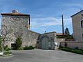
 Town hall (Mairie) of La Chapelle |
||

La Chapelle is a French commune with 214 inhabitants (at January 1, 2017) in the department of Charente in the region Nouvelle-Aquitaine (before 2016 Poitou-Charentes ); it belongs to the Arrondissement Confolens ( Angoulême until 2017 ) and the canton Boixe-et-Manslois ( Saint-Amant-de-Boixe until 2015 ).
geography
La Chapelle is located about 22 kilometers north-northwest of Angoulême on the Charente . La Chapelle is surrounded by the neighboring communities of Ambérac in the north, Coulonges in the east, Vouharte in the south-east, Genac-Bignac in the south and south-west and Marcillac-Lanville in the west and north-west.
Population development
| 1962 | 1968 | 1975 | 1982 | 1990 | 1999 | 2006 | 2013 |
|---|---|---|---|---|---|---|---|
| 157 | 137 | 140 | 150 | 148 | 151 | 181 | 216 |
| Source: Cassini and INSEE | |||||||
Attractions
- Saint-Antoine church, former priory
- Coming of the Knights Templar of Fouilloux

Saint-Antoine church
Coming from Fouilloux


Web links
Commons : La Chapelle - collection of images, videos and audio files